
Hide
--- TEST SYSTEM --- TEST SYSTEM --- TEST SYSTEM ---
Hide
Kilbride Parish
hide
Hide
(aka Kilbride-Castlecor)
Hide
hide
Hide
hide
Hide
Hide
"Kilbride, or Castlecorr, a parish, partly in the barony of Demfore, county of Meath, and province of Leinster but chiefly in the barony of Clanmahon, county of Cavan, and province of Ulster, on the road from Mount-Nugent to Oldcastle; containing, with the post-town of Mount-Nugent, 4658 inhabitants. It comprises 8777 statute acres, as applotted under the tithe act, of which about three-fifths are arable, a tenth bog, and the remainder pasture: limestone is abundant. The principal seats are Bobsgrove, the residence of C.E.J. Nugent, Esq.; Roebuck, of W. Reilly, Esq.; and Castlecorr, of W. Webb, Esq. The living is a rectory, in the diocese of Meath, the presentation to which is in dispute between the Crown and Lord Dunsany: the tithes amount to £415.9. 9. The church was built in 1800, and has been recently repaired, for which the Ecclesiastical Commissioners granted £157 The glebe-house is supposed to have been erected before the Reformation; the glebe comprises 22 acres. In the R. C. divisions this parish forms part of the union or district of Killeagh and Kilbride, and has a chapel at Mount-Nugent. About 70 children are educated in a public school, for which the house and an acre of land were given by Mr. Nugent; and about 850 children are taught in five private schools."
[From Lewis' Topographical Dictionary (1837)]
Hide
| Gallonreagh, Kilbride, Unknown Denomination |
| St Bridget, MOUNT NUGENT, Roman Catholic |
| Gallonreagh, Kilbride, Unknown Denomination |
| Tullyboy, Kilbride, Methodist |
| St Bridget, MOUNT NUGENT, Roman Catholic |
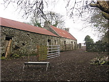 Old farmstead, Raclaghy, Co. Cavan © Copyright Kieran Campbell and licensed for reuse under this Creative Commons Licence. | 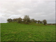 Ringfort, Garrysallagh, Co. Cavan © Copyright Kieran Campbell and licensed for reuse under this Creative Commons Licence. |
The transcription for this parish from the National Gazetteer (1868), provided by Colin Hinson.
- Ask for a calculation of the distance from Kilbride Parish to another place.
Parish of Kilbride, County Meath
- It should be noted that there is another parish of Kilbride in County Meath which can be a source of confusion. The parish connected to the county Cavan parish of Kilbride is in the Poor Law Union of Oldcastle and the barony of Fore. The other Kilbride is in the Poor Law union of Dunshaughline and the barony of Dunboyn.
- Townlands: Ardfrail, Castlecor, Farranaglogh, Glebe, Glenboy
The townland of Kilbride and the town of MOUNT NUGENT are both in the parish of Kilbride
- O'Connell, P., "The Parish and District of Kilbride - Part I", Riocht Na Midhe, 1962, v.2, p.5-16.
- O'Connell, P., "The Parish and District of Kilbride - Part II Sixteenth Century Landowners", Riocht Na Midhe, 1963, v.3, n.1, p.3-.
- O'Connell, P., "The Parish and District of Kilbride - Part III The Church of Kilbride", Riocht Na Midhe, 1963, v.3, n.1, p.89-95.
- O'Connell, P., "The Parish and District of Kilbride - Part IV Oldcastle", Riocht Na Midhe, 1963, v.3, n.1, p.172-180.
- Farnham Estate
- James O'Reilly: Rentals, 1815-16, NAI M.6962
- Land Owners in Ireland, 1876, Reprinted: Genealogical Publishing Company, Baltimore, MD, 1998.
- Persons who own property in County Cavan and were listed as living in a Townland of Kilbride
- Bobsgrove
- St. George Nugent
- Cavancoulter
- William Byars
- William Major
- Dungummin
- James Campbell
- Pollakeel
- Edward Brady
- Roebuck
- Edward Brady
- John B. Lynch
- Mrs. Joseph Lynch
- Tonagh
- Patrick Bartley
- William Bartley
- Bobsgrove
- Persons who own property in County Cavan and were listed as living in a Townland of Kilbride
You can see maps centred on OSI grid reference N4932585285 (Lat/Lon: 53.814891, -7.251897), Kilbride Parish which are provided by:
- OpenStreetMap
- Google Maps
- Bing (was Multimap)
- Copy
Kilbride Parishand paste it along with the county name into the search box at Ordnance Survey Ireland. - GeoHack (Links to on-line maps and location specific services.)
- All places within the same township/parish shown on an Openstreetmap map.
- Nearby townships/parishes shown on an Openstreetmap map.
- Nearby places shown on an Openstreetmap map.
- 1796 Flax Growers Surname List - for given names and number of spinning wheels allotted see the extraction by Adrian Donelly
- Allen, Anderson, Armstrong, Boylan, Brady, Caffry, Carney, Carroll, Comerford, Connell, Cooke, Cullen, Daly, Darcy, Donelly, Donely, Donohoe, Duncan, Finegan, Fitzsimons, Flanagan, Flood, Flyn, Gaffney, Galligan, Garry, Gaughran, Gibney, Gordon, Gulan, Hanagan, Holiday, Kellery, Lee, Lenahan, Leonard, Limmer, Lynch, Maclane, Magauran, Maguire, Mangin, Mannin, Masterson, McCabe, McCann, McEnroe, McEntire, McLaughlin, McNally, Monaghan, Murphy, Murray, Nugent, O'Brien, Olwell, Olwell, Owenson, Plunket, Reilly, Reynolds, Sandom, Scally, Sheridan, Sheridan, Smyth, Strong, Sullivan, Tuite, Wheeler
- 1821 Census
- Mountnugent - Daniel Falloon (Fallon), aged 55, schoolmaster Dungimmon - two schools are entered in this townland; one comprising 32 boys and 15 girls and the other, 29 boys and 14 girls. No teachers names are given.
- Tonagh - the names of two schoolmasters living in this townland are recorded: Thomas Lynch, aged 75, and his son Patrick, aged 22
- 1824 Survey
- Kilbrady - Christopher Nugent conducted the parish school at Poleragh (Pollareagh) with an attendance of 34 - 14 boys and 20 girls.