Hide
--- TEST SYSTEM --- TEST SYSTEM --- TEST SYSTEM ---
Hide
Surrey
hide
Hide
hide
- Archives & Libraries
- Bibliography◬
- Biography◬
- Business & Commerce Records◬
- Cemeteries◬
- Census◬
- Chronology◬
- Church History
- Church Records
- Civil Registration
- Correctional Institutions◬
- Court Records◬
- Description & Travel
- Directories◬
- Emigration & Immigration◬
- Gazetteers◬
- Genealogy
- Historical Geography
- History
- Land & Property◬
- Language & Languages◬
- Law & Legislation◬
- Manors◬
Hide

Hide
Hide
hide
- Maps
- Medical Records◬
- Merchant Marine◬
- Migration, Internal◬
- Military History◬
- Names, Geographical
- Names, Personal
- Newspapers
- Occupations
- Periodicals
- Politics & Government◬
- Poor Houses, Poor Law◬
- Population◬
- Probate Records◬
- Public Records◬
- Schools◬
- Social Life & Customs◬
- Societies
- Statistics◬
- Taxation◬
- Town Records◬
- Voting Registers◬
Hide
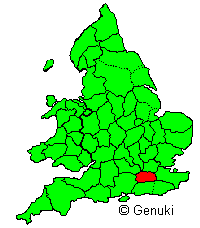
County in SE. of England, bounded N. by the Thames, which separates it from Bucks and Middlesex, E. by Kent, S. by Sussex, W. by Hants, and NW. by Berks; greatest length, N. and S., 26 miles; greatest breadth, E. and W., 40 miles; area, 485,129 acres, population 1,436,899. The County is traversed from E. to W. by the North Downs range, from which the surface slopes gently down towards the Thames on the N., while on the S. it descends into an extensive flat plain (partly also in the counties of Kent and Sussex) called the Weald. Except a small portion in the SW., and another small portion in the SE., the whole of the County is drained by the Thames and its tributaries, the Wey, Mole, and Wandle. There are many varieties of soil, including plastic and alluvial clays, rich vegatable loam, calcareous earth, and almost barren heath. On the plastic clays the crops are wheat and beans; the alluvial soils, particularly in the vicinity of the metropolis, are chiefly occupied by orchards, market gardens, and farms for the culture of medical and aromatic plants; on the loamy soils the crops are barley, oats, and pease, carrots and parsnips; while the chief products of the calcareous soils are hops and clover. There are some industries in oil, paper, calicoes, woollen goods, &C., and those places situated on the Thames share in the trade of the port of London, but (except in that part of the County included within the limits of the metropolis) the trade and manufactures are not of great importance. The amenities of climate and scenery, the vicinity of the metropolis, and the complete means of railway communication, have caused many parts of Surrey to be studded over with mansions and villas. The County contains 14 hundreds, 152 parishes with parts of 2 others, the parliamentary and municipal borough of Croydon (1 member), the parliamentary boroughs of Battersea and Clapham (2 members), Camberwell (3 members), Lambeth (4 members), Newington (2 members), Southwark (3 members), and Wandsworth (1 member) - all the parliamentary boroughs being metropolitan except Croydon, and the municipal borough of Godalming, Guildford, Kingston upon Thames, and Reigate. The County is in the dioceses of Canterbury, Rochester and Winchester. For parliamentary purposes it is divided into 6 divisions - viz., North-Western or Chertsey, South-Western or Guildford, South-Eastern or Reigate, Mid or Epsom, Kingston, and North-Eastern or Wimbledon, 1 member for each division. (Transcribed from Bartholomew's Gazetteer of the British Isles, 1887. -C.H.)
Hide
- Surrey History Service
- Surrey Public Libraries
- Local history centres in Surrey libraries:
- The London Archives(formerly the London Metropolitan Archives) hold records relating to Surrey parishes which are now in South London
- J. E. Morris, County Churches: Surrey, London 1910
- Location
- Records of parishes in the Diocese of Guildford are held by the Surrey History Centre
- Records of parishes in the Diocese of Southwark are held by the Surrey History Centre or, for those in South London, by the London Metropolitan archives
- Records of parishes in the Diocese of London are held by the London Metropolitan Archives
- Guide to Parish Registers held at Surrey History Centre - in fact lists details and locations for all Surrey parishes.
- John Harvey has prepared a list of IGI Batch Nos for Surrey, which will be of use to those wishing to identify Surrey records on the FamilySearch website.
- Registration Districts in Surrey for the period 1837-1974.
- Edward Wedlake Brayley, A Topographical History of Surrey, Vol. II London 1850
- Thomas Cromwell, Excursions in the County of Surrey: Comprising Brief Historical and Topographical Delineations
- Thomas Allen, A history of the county of Surrey, Vol I London 1831
- G. F. Prosser, Select Illustrations of the County of Surrey London 1828
- Forums
- Surrey Forums at RootsChat
- The Surrey county-wide forum (British-Genealogy.com)
- Administrative boundaries of the county of Surrey (Surrey History Centre)
- List of topographical articles in the Surrey volumes of the Victoria County History
- Exploring Surrey's Past
- Surrey in the Great War: A County Remembers
- Surrey Interactive Map (the present-day county)
- Joan Blaeu's 1645 Map of Surrey
- Map Of The County Of Surrey From Trigonometrical Survey With The Roads, Parks & Railways 1874
- 1885 Boundary Commission maps of West Surrey and East Surrey
- Surrey Old Maps (Genmaps) - an extensive collection of scans
- Old Maps Online: Surrey
- 25 inch Ordnance Survey Maps: Surrey, 1896-1947 (individual sheets)
- Ordnance Survey 1:10,560, 1871-1882, Surrey (British History Online)
- Index of Place Names in Pigot's Commercial Directory for Surrey, 1839
- Index of Surnames in Pigot's Commercial Directory for Surrey, 1839
- Historical Directories: Surrey (6 directories, 1851-1913)
- On-line index to The Surrey Advertiser for 1864-1867 & 1872.
- The Surrey Archaeological Society publishes the Surrey Archaeological Collections with articles "realting to the history and antiquities of the county ". The Archaeology Data Service has:
