
Hide
--- TEST SYSTEM --- TEST SYSTEM --- TEST SYSTEM ---
Hide
Kilbride Down Survey Map
hide
Hide
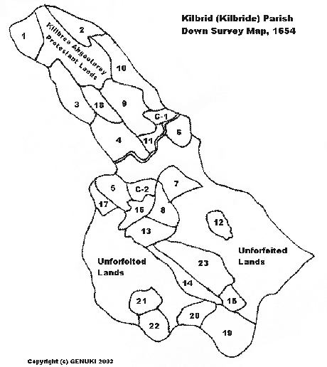
| Map Reference | Townland | Modern counterpart according to O'Connell, P. "The Parish and District of Kilbride Part II. - Sixteenth Century Landowners", Riocht Na Midhe, 1963, vol. 3, no. 1, pp. 3-14. |
| 1. | Tulliboy | Tullyboy |
| 2. | Aghenedaragh | Aghnahederny |
| 3. | Killfassy | |
| 4. | Ballahana | Ballaghanna |
| 5. | Garrisallagh | Garrysallagh |
| 6. | Pullyreagh | Pollareagh |
| 7. | Aghavonan | Aghawonan |
| 8. | Lissdrumbrin | Lisnabrinnia |
| 9. | Dyrundun | Western section of present townland of Kilbride bordering Cavancoulter |
| Killbree Aghootery Protestant Lands | Aghoutereery of the Ordnance Survey maps | |
| 10. | Bellangrosse | Gallonbane and northern section of present townland of Kilbride. |
| C-1 | Kilbride Church Land | |
| C-2 | Dunulchan Glebe Land | A section of Garrysallagh with part of Aghnaskeagh |
| 11. | Racravin | Racraveen |
| 12. | Clonbogy | Clonbockoge |
| 13. | Crossragh | |
| 14. | Pullykeele | Pollakeel |
| 15. | Raghclogher | Raclaghy |
| 16. | Aghanaskeagh | Aghnaskeagh |
| 17. | Cunlin-gallon | Conleen |
| 18. | Cavancoulter | |
| 19. | Raghymor | Raheever |
| 20. | Cluntyduffe | Clontyduffy |
| 21. | Faranconnell | Bobsgrove |
| 22. | Gnew | Gneeve |
| 23. | Garry robucke | Roebuck |
| Unforfeited Lands | Dungummon, Mountpallas, Tullyagan, Corwin, Tonagh |