
Hide
--- TEST SYSTEM --- TEST SYSTEM --- TEST SYSTEM ---
Hide
Great Bircham
hide
Hide
hide
Hide
hide


Hide
Hide
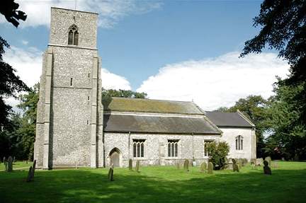
"BIRCHAM, (GREAT) a village and parish, on the Burnham road, 14 miles N.E. of Lynn, has 511 inhabitants, and 3,542 acres of land, of which a part is sheep walk, and 246A. are in woods and plantations. The Marquis of Cholmondeley is owner of the soil and lord of the manor. The CHURCH (St. Mary,) on an eminence, has a fine tower at the west end, containing five bells. It is a handsome structure, very indifferently pewed; and during the progress of some recent repairs, three piscinas were discovered. The rectory, valued in the King's Book at £22, and in 1831 at £527, has about 70 acres of glebe. Anthony Hamond, Esq., is the patron, and the Rev. Wm. Pratt, B.A., of Harpley, incumbent. . . . A Free School, for the poor children of the three Bircham parishes, was built in 1842, by the Marquis Cholmondeley, who also supports two small preparatory schools, and partly clothes the scholars, of whom, about 80 attend the principal school." [William White, History, Gazetteer, and Directory of Norfolk (1845) - Transcription copyright © Ian Wegg]
Hide
Great Bircham is about 10 miles W. of Fakenham.
It is sometimes known as Bircham St Mary.
See also Bircham Newton and Bircham Tofts.
Hide
- 1811: Names of Householders, Males and Females in Families, etc.
- 1891: Surname List (this is a link to an archived copy)
See also Norfolk Parish Links: Censuses
- In 1883 the parish was in the Deanery of Heacham, in the archdeaconry of Norfolk.
It could have been in a different deanery or archdeaconry both before and after this date. - The parish church is dedicated to St Mary.
- Church of St Mary the Virgin (this is a link to an archived copy)
- Description, pictures, bells, etc.
- Church of St Mary the Virgin
- Picture of the church.
- Yaxley, David
- The Old Rectory, Great Bircham.
[Norwich, Norfolk and Norwich Archaeological Society, in "Norfolk Archaeology" vol.37, 1980]
- Marriages 1669-1837
- See Phillimore's Marriage Registers, Volume 12.
- Marriages
- These are included in Boyd's Marriage Index.
See also Norfolk Parish Links: Church Records
For the civil registration of births, marriages and deaths between 1837 and 1930 (and for the censuses from 1851 to 1901), Great Bircham was in Docking Registration District.
- Great Bircham Post Mill
- Description and history.
- Great Bircham Tower Mill
- Description, history and picture.
- Great Bircham Windmill
- Pictures and short history.
- 1845: White's History, Gazetteer, and Directory of Norfolk
- 1864: White's History, Gazetteer, and Directory of Norfolk
- 1883: White's History, Gazetteer, and Directory of Norfolk
- 1883: Kelly's Directory for Cambridgeshire, Norfolk and Suffolk (this is a link to an archived copy)
See also Norfolk Parish Links: Directories
- Ask for a calculation of the distance from Great Bircham to another place.
Great Bircham is in Smithdon Hundred.
- Parish outline and location.
- See Parish Map for Smithdon Hundred
- Description of Smithdon Hundred
- 1845: White's History, Gazetteer, and Directory of Norfolk
- Great Britain: Statute
- Great Bircham Land Exchanges and Inclosure Act, 1739.
An act for confirming and establishing an exchange, agreed upon by the lord of the manor and the rector of the parish church of Great Bircham in the county of Norfolk; and for promoting and facilitating an inclosure, intended to be made of divers commons, common pasture and waste grounds, lying in the said parish of Great Bircham.
[1739]
You can see maps centred on OS grid reference TF768326 (Lat/Lon: 52.861876, 0.625025), Great Bircham which are provided by:
- OpenStreetMap
- Google Maps
- StreetMap (Current Ordnance Survey maps)
- Bing (was Multimap)
- Old Maps Online
- National Library of Scotland (Old Ordnance Survey maps)
- Vision of Britain (Click "Historical units & statistics" for administrative areas.)
- English Jurisdictions in 1851 (Unfortunately the LDS have removed the facility to enable us to specify a starting location, you will need to search yourself on their map.)
- Magic (Geographic information) (Click + on map if it doesn't show)
- GeoHack (Links to on-line maps and location specific services.)
- All places within the same township/parish shown on an Openstreetmap map.
- Nearby townships/parishes shown on an Openstreetmap map.
- Nearby places shown on an Openstreetmap map.
- Roll of Honour
- World Wars 1 and 2.
- Roll of Honour - War Graves in the Churchyard
- World Wars 1 and 2.
- War Graves at Great Bircham
- Some of the people were from Bircham Newton airfield.
Names, details, pictures, plan of graves, etc.
This is a link to an archived copy. - Hillman, Brian and Beynon, John
- The British, Commonwealth and German War Graves in St Mary's Churchyard, Great Bircham.
[King's Lynn, 2002]
- After 1834 Great Bircham became part of Docking Union, and the workhouse was at Docking.
These figures are from the population tables which were produced after the 10-yearly national censuses. The "Families" heading includes families and single occupiers.
|
|
There may be more people living in detached parts of the parish (if there were any) and, if so, the number may or may not be included in the figures above. It is quite difficult to be sure from the population tables.