
Hide
--- TEST SYSTEM --- TEST SYSTEM --- TEST SYSTEM ---
Hide
Docking
hide
Hide
hide
Hide
hide


Hide
Hide
"DOCKING, a parish in the hundred of SMITHDON, county of NORFOLK, 5 miles (S.W. by W.) from Burn-Kam-Westgate,. containing 1107 inhabitants. The living is a discharged vicarage, in the archdeaconry of Norfolk, and diocese of Norwich, rated in the king's books at £13. 6. 8., and in the patronage of the Provost and Fellows of Eton College, on the nomination of the Bishop of Norwich. The church is dedicated to St. Mary. There is a place of worship for Wesleyan Methodists. In the charter of endowment of Eton College, mention is made of the Alien priory of Dokkyng: the monks are supposed by Dr. Tanner to have belonged to the abbey de Ibreio in Normandy, to which this church was formerly appropriated. Summerfield House, about two miles north-westward, is a corruption of Suthmere, which at the period of the Norman survey, and later, was a town of some importance, with a church dedicated to All Saints, of which there are not at present any vestiges." [Samuel Lewis, A Topographical Dictionary of England (1831) - copyright © Mel Lockie]
Hide
Docking is about 6 miles east south east of Hunstanton.
It is also called Dry Docking.
Hide
- 1891: Surname List (this is a link to an archived copy)
- 1891: Docking Workhouse: Surname List (this is a link to an archived copy)
See also Norfolk Parish Links: Censuses
- In 1883 the parish was in the Deanery of Heacham, in the archdeaconry of Norfolk.
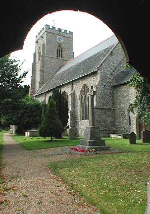
It could have been in a different deanery or archdeaconry both before and after this date. - The parish church is dedicated to St Mary the Virgin.
- Church of St Mary
- Picture of the church and war memorial.
- Church of St Mary
- Picture of the church and war memorial.
- Cumming, Graham
- The history of the Church of St Mary the Virgin, Docking.
[1959?]
- Docking with Southmere Marriages 1558-1837
- See Phillimore's Marriage Registers, Volume 12.
See also Norfolk Parish Links: Church Records
- Docking
- Description, church, pictures, etc.
This is a link to an archived copy. - Arter, Tony (compiler)
- Docking, a village in Norfolk.
[2000?] - Elms, Hermeina and Wells, Eileen
- Docking, a walk in time, a memento of the village for the Millennium, 2000.
[Docking, 2000]
- 1883: Kelly's Directory for Cambridgeshire, Norfolk and Suffolk (this is a link to an archived copy)
- Ask for a calculation of the distance from Docking to another place.
Docking is in Smithdon Hundred.
- Parish outline and location.
- See Parish Map for Smithdon Hundred
- Description of Smithdon Hundred
- 1845: White's History, Gazetteer, and Directory of Norfolk
- Hagan, Gerald
- Dry Docking: being some account of the history and records of a Norfolk village.
[King's Lynn, Norfolk, 1983]
You can see maps centred on OS grid reference TF768369 (Lat/Lon: 52.900774, 0.627849), Docking which are provided by:
- OpenStreetMap
- Google Maps
- StreetMap (Current Ordnance Survey maps)
- Bing (was Multimap)
- Old Maps Online
- National Library of Scotland (Old Ordnance Survey maps)
- Vision of Britain (Click "Historical units & statistics" for administrative areas.)
- English Jurisdictions in 1851 (Unfortunately the LDS have removed the facility to enable us to specify a starting location, you will need to search yourself on their map.)
- Magic (Geographic information) (Click + on map if it doesn't show)
- GeoHack (Links to on-line maps and location specific services.)
- All places within the same township/parish shown on an Openstreetmap map.
- Nearby townships/parishes shown on an Openstreetmap map.
- Nearby places shown on an Openstreetmap map.
- Docking Union and Workhouse
- Description from White's Directory of Norfolk, 1845.
- Docking Union and Workhouse
- Description and pictures.