
Hide
--- TEST SYSTEM --- TEST SYSTEM --- TEST SYSTEM ---
Hide
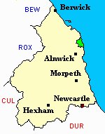
Embleton
hide
Hide
hide
Hide
Hide
Hide
"EMBLETON parish comprises the chapelries of Rock and Rennington, and the townships of Broxfield, Brunton High and Low, Craster, Dunston, Embleton, Falloden, Newton by the Sea, and Stamford. It is bounded on the north by Doxford and Tuggall, on the west by North and South Charlton, on the south by Howick, Longhoughton, and Denwick, and on the east by the German Ocean. It is about five miles long by three and a half broad, and comprises an area of 13,228 acres. The population of this parish in 1801, was 1,515; in 1811, 1,526; in 1821, 1,806; in 1831, 1,929; in 1841, 2,030; and in 1851, 2,275." [From History, Topography, and Directory of Northumberland, Whellan, 1855].
Hide
- Around Embleton what the papers say John Yearnshire 2017
- History of Northumberland vol 2 Edward Bateson 1896 includes Embleton
- Burials Grant Book 1975-1990 for Embleton Civil Cemetery is available at Northumberland Record Office
- Northumberland County Record Office hold copies of Census Returns 1841 - 1891 and provides a useful User Guide
- The 1851 Census Index (microfiche CN33) Embleton, Edlington, Whittingham, Eglingham (part), Longhoughton, Howick and Ellingham (PRO piece HO107/2419 folios 564-820) (Type B) (Book)
- 1891 Census Northumberland – Embleton (Edlingham, Eglingham, Longhoughton, Craster, Dunstan, Embleton, Newton by the Sea, Rock and Rennington (PRO piece RG12/4265) (Type B) (Book) (Volume 75) BOTH published by the https://www.ndfhs.org.uk/ may be of value to researchers interested in this parish.
- Index to the 1891 Census of Northumberland vol 75 N.D.F.H.S. includes Embleton is a vailable to view at The Local Studies Centre Newcastle City Library [shelf ref; L312]
- The Ancestral Indexes website provides information about Craster, St Peter and Newton by the Sea Mission Church.
Church of England Records.
- Embleton, Holy Trinity: Records of baptisms 1682-1983, marriages 1682-1962 and burials 1682-1934 are available at Northumberland Record Office
- Bishops' Transcripts for the period 1762-1850 are deposited at Durham University Library Archives and Special Collections, Palace Green, Durham City.
- The International Genealogical Index (I.G.I.) includes baptisms 1660-1812 and marriages 1682-1812 for this parish
- Boyd's Marriage Index includes marriages 1682-1812 and banns 1754-1812.
- Transcripts of baptisms 1660-1812 and marriages and burials 1682-1812 for Embleton are available at Newcastle Central Library, Local Studies Dept.
- A photograph of Embleton, Holy Trinity supplied by George Bell.
Nonconformist Records.
- Embleton (Presbyterian): Records of births/baptisms 1833-1984 are available to view at Northumberland County Record Office
- The Story in brief of Embleton Prebyterian Church 1833 - 1933 is available to view at The Local Studies Centre, Newcastle City Library [shelf ref; L285.2 E53]
Adjacent Parishes.
The following parishes are adjacent to Embleton:- Bamburgh, Ellingham, Howick, Long Houghton, Rennington, Rock.
- This area is within Northumberland North Second Registration District.
- Certificates of birth, death and marriage can be ordered locally from Northumberland County Council.
- Photographs of Dunstanburgh Castle and the surrounding coastline from Mirror Image.
- Photographs of Embleton Bay, Craster, Cullernose Point, Dunstanburgh and Low Newton from Les Bell's Northumberland Cam website.
- The Northumberland Communities website includes pages relating to Craster and Embleton. They provide "a range of learning resource material that reflects Northumberland's heritage, providing a base for studying the County's history. The website provides a starting point for understanding the development of communities in Northumberland. It also seeks to illustrate the range of sources for family and local history research that are available via Northumberland Archives Service."
- The section of The National Gazetteer (1868) relating to this parish - transcribed by Colin Hinson.
- Ask for a calculation of the distance from Embleton to another place.
- The history of Embleton Parish is included in:- Northumberland County History Committee, History of Northumberland, Volume 2. Newcastle, A. Reid, 1895.
- Embleton - Maps - links and information.
You can see maps centred on OS grid reference NU217214 (Lat/Lon: 55.485968, -1.657605), Embleton which are provided by:
- OpenStreetMap
- Google Maps
- StreetMap (Current Ordnance Survey maps)
- Bing (was Multimap)
- Old Maps Online
- National Library of Scotland (Old Ordnance Survey maps)
- Vision of Britain (Click "Historical units & statistics" for administrative areas.)
- English Jurisdictions in 1851 (Unfortunately the LDS have removed the facility to enable us to specify a starting location, you will need to search yourself on their map.)
- Magic (Geographic information) (Click + on map if it doesn't show)
- GeoHack (Links to on-line maps and location specific services.)
- All places within the same township/parish shown on an Openstreetmap map.
- Nearby townships/parishes shown on an Openstreetmap map.
- Nearby places shown on an Openstreetmap map.