
Hide
--- TEST SYSTEM --- TEST SYSTEM --- TEST SYSTEM ---
Hide
Hollacombe
hide
Hide
hide
- Almanacs◬
- Archives & Libraries◬
- Bibliography◬
- Biography
- Business & Commerce Records◬
- Cemeteries
- Census
- Chronology◬
- Church History
- Church Records
- Churches
- Civil Registration◬
- Correctional Institutions◬
- Court Records◬
- Description & Travel
- Directories◬
- Emigration & Immigration◬
- Encyclopaedias & Dictionaries◬
- Folklore◬
- Gazetteers
- Genealogy◬
- Handwriting◬
- Heraldry◬
- Historical Geography◬
Hide
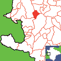
Click on map to view parish boundaries in detail.
Hide
Hide
hide
- History
- Jewish History◬
- Land & Property
- Language & Languages◬
- Manors◬
- Maps
- Medical Records◬
- Merchant Marine◬
- Military History◬
- Names, Geographical◬
- Names, Personal◬
- Newspapers◬
- Occupations◬
- Periodicals◬
- Politics & Government◬
- Poor Houses, Poor Law◬
- Population◬
- Probate Records◬
- Schools◬
- Social Life & Customs◬
- Societies◬
- Taxation◬
- Voting Registers◬
Hide
"HOLLACOMBE, a small parish, near the sources of the small river Claw, 2½ miles E. by S. of Holsworthy, has only 132 souls, and 1218 acres. Mr. Thomas Brown, of Hayne, owns about two thirds of the land, and the rest belongs to the Misses May, of Bath, and a few smaller owners. The Church (St. Petrock,) is a small antique fabric, with a low tower and three bells. The rectory, valued in K.B. at £4. 6s. 3d., and in 1831 at £78, is in the patronage of the Lord Chancellor, and incumbency of the Rev. J.C.D. Yule, M.A., of Bradford. The glebe is 32A. The FARMERS are, Thos. Brown, owner and cattle dealer, Hayne; Ann Bailey, Sellick; Wm. Brown, East Coombe; James Boles, Headon; Thomas Jordon, cattle dealer, Eastdown; and John Sandercock, West Coombe." [From White's Devonshire Directory (1850)]
A parish in Black Torrington Hundred, and the Archdeaconry of Totnes and Diocese of Exeter.
Hide
South West Police Heritage Trust, Devon Family Historian, vol. 168, (2018) p.6. [Concerns P.C. William Berry (d.1918 at Ypres.)]
Whitmore, J.B. Devonshire Monumental Inscriptions, MS at Society of Genealogists (1951). [Extracts]
Snetzler, M.F. North Devon Surname Index to the Census. Microfiche: M.F. Snetzler. [Covers 1841, 1861, 1871 and 1881 census records for this parish]
Hollacombe - from J. Stabb. Some Old Devon Churches (London: 1908-16).
Parish Registers going back to 1638 are held in the Devon Record Office.
Indexed transcripts of the Parish Registers going back to 1638, and of the Bishops' Transcripts going back to 1608, are held in a special collection in the Westcountry Studies Library.
The Devon FHS publishes indexes covering (as of June 2004): Marriages 1754-1837 - for details see their Devon Parish List.
Entered into the IGI (as of Jan 1993): Parish Church Christenings 1608-1855 Marriages 1608-1625, 1640-1715, 1729-1793, 1838-1871. (These entries are in part from Bishops' Transcripts.)
Kirst Gray offers look-ups of the PRs for the years 1838-1930.
An index of baptisms, marriages and burials in the parishes of Abbots Bickington, Ashwater, Black Torrington, Bradford, Bradworthy, Bridgerule, Clawton, Cookbury, Halwill, Hollacombe, Holsworthy, Luffincott, Milton Damerel, Pancrasweek, Pyworthy, Sutcombe, Tetcott, Thornbury, West Putford and Holsworthy Weslyan Burials. With photographs of the churches and extracts from White's Directory (1850), Kelly's Directory of Devonshire (1902) and A Topographical Dictionary of England, Samuel Lewis (1831), CD-ROM, Exeter, Devon FHS (2014). [Abbots Bickington Bapt: 1813-1840 Mar: 1770-1833 Bur: 1813-1837; Ashwater Bapt: 1813-1841 Mar: 1754-1837 Bur: 1813-1837; Black Torrington Bapt: 1813-1839 Mar: 1754-1837 Bur: 1813-1837; Bradford Bapt: 1813-1839 Mar: 1754-1837 Bur: 1705-1837; Bradworthy Bapt: 1813-1838 Mar: 1755-1837 Bur: 1813-1837; Bridgerule Bapt: 1813-1839 Mar: 1755-1837 Bur: 1813-1837; Clawton Bapt: 1813-1839 Mar: 1754-1837 Bur: 1800-1837; Cookbury Bapt: 1813-1839 Mar: 1756-1837 Bur: 1813-1841; Halwill Bapt: 1813-1839 Mar: 1754-1837 Bur: 1813-1843; Hollacombe Bapt: 1813-1898 Mar: 1757-1837 Bur: 1813-1852; Holsworthy Bapt: 1813-1839 Mar: 1754-1860 Bur: 1813-1837; Holsworthy Weslyan Bapt: 1812-1831; Luffincott Bapt: 1813-1839 Mar: 1756-1837 Bur: 1814-1840; Milton Damerel Bapt: 1813-1840 Mar: 1761-1837 Bur: 1813-1837; Pancrasweek Bapt: 1813-1840 Mar: 1756-1837 Bur: 1813-1837; Pyworthy Bapt: 1813-1839 Mar: 1755-1837 Bur: 1813-1838; Sutcombe Bapt: 1813-1840 Mar: 1754-1837 Bur: 1800-1837; Tetcott Bapt: 1813-1839 Mar: 1755-1836 Bur: 1813-1837; Thornbury Bapt: 1813-1839 Mar: 1756-1837 Bur: 1813-1837; West Putford Bapt: 1813-1840 Mar: 1754-1837 Bur: 1813-1838.]
Section on Hollacombe from Samuel Lewis: A Topographical Dictionary of England (1831), provided by Mel Lockie.
The transcription of the section for this parish from the National Gazetteer (1868), provided by Colin Hinson.
- Ask for a calculation of the distance from Hollacombe to another place.
Notes from Parish Records on Oath-takers from Ashwater, Broadwoodwidger, Hollacombe, Holsworthy and St Giles in the Heath by Pat Williams, provided by the Friends of Devon Archives.
Transcriptions of lease agreements between John and Thomas Browne (1711) and between Charles and Thomas Browne (1815) provided by Elizabeth Howard.
View a map of the boundaries of this town/parish.
You can see maps centred on OS grid reference SS377030 (Lat/Lon: 50.803766, -4.30469), Hollacombe which are provided by:
- OpenStreetMap
- Google Maps
- StreetMap (Current Ordnance Survey maps)
- Bing (was Multimap)
- Old Maps Online
- National Library of Scotland (Old Ordnance Survey maps)
- Vision of Britain (Click "Historical units & statistics" for administrative areas.)
- English Jurisdictions in 1851 (Unfortunately the LDS have removed the facility to enable us to specify a starting location, you will need to search yourself on their map.)
- Magic (Geographic information) (Click + on map if it doesn't show)
- GeoHack (Links to on-line maps and location specific services.)
- All places within the same township/parish shown on an Openstreetmap map.
- Nearby townships/parishes shown on an Openstreetmap map.
- Nearby places shown on an Openstreetmap map.