
Hide
--- TEST SYSTEM --- TEST SYSTEM --- TEST SYSTEM ---
Hide
Peterston super Montem
hide
Hide
hide
Hide
hide
Hide
Hide
"PETERSTONE, or, LLAN BEDR AR FYNYDD, in the Cwmwd of Tir yr Hwndrwd, Cantref of Cron Nedd (now called the Hundred of Newcastle), County of GLAMORGAN, South Wales; in the Parish of Coed Du Church [Coychurch]: a Chapel, not in charge, always holden with the Rectory of Coed Du Church, and of the certified value of £14: Patron, Thomas Wyndham, Esq.: Chapel dedicated to St. Peter. The Resident Population of this Hamlet, in 1801, and the Money raised by the Parish Rates, in 1803, are included in the Returns made from Coed Du Church."
From: A Topographical Dictionary of The Dominion of Wales by Nicholas Carlisle, London, 1811.
"PETERSTON super MONTEM, a chapelry in the parish of COYCHURCH, hundred of NEWCASTLE, county of GLAMORGAN, SOUTH WALES, 8 miles (N. E. by E.) from Bridgend, containing 134 inhabitants. It is in Welsh called Llanbedr ar Vynydd, " the church of St. Peter on the mountain," and is situated on the confines of the hundreds of Ogmore and Cowbridge, at some distance from the mother church. It occupies the southern declivity of the monntain of Mynydd y Rhiw, and the inhabitants are exclusively engaged in agriculture. The river Ely partly bounds it on the north. The chapel is dedicated to St. Peter : attached to it is a Welsh Sunday school. A sum of £15 has been left to the poor of this chapelry ; besides which, twenty-five shillings per annum are distributed among those not receiving parochial relief. The average annual expenditure for the support of the poor amounts to £ 66. 14." ( A Topographical Dictionary of Wales by Samuel Lewis 1833)
Hide
Here is a substantial reading list of books which relate to Glamorgan, either county or parish.
| St Peter, Brynna |
| St Peter, Llanbad |
| Brynna Congregational Chapel, Brynna |
| Nazareth Independent Chapel, Brynna |
| United Methodist Church, Brynna |
Chapels Database - a list of all known non-conformist chapels or other non-Anglican religions in the parish
For full and up-to-date details of their holdings see the sites of Glamorgan Record Office and/or West Glamorgan Archives
See Bap/Mar/Bur data on FreeReg
The church is dedicated to St. Peter, is in the Benefice of Llanharan with Peterston-super-Montem (or Brynna), and the diocese of Llandaff. Details of the present incumbent of this benefice can be found at the Church in Wales website. The church can be located at grid reference SS985833.
A transcription of the registers is available from the Glamorgan Family History Society for the years: Baptisms, 1745-1900, Marriages, 1721-1837, Burials, 1745-1900.
| Anglican Parish Registers Held at the Glamorgan Record Office, Cardiff | ||||
| Baptisms | Marriages | Burials | Banns | Bishops Transcripts |
| 1745-1811, 1813-1970 | 1745-1970 | 1745-1992 | 1754-1812 | 1721, 1732-1735, 1737-1748, 1750-1753, 1755-1795, 1797-1837 |
Details of extant records on Archives Network Wales for the following;
- Peterston-super-Montem Ecclesiastical Parish records "........ including registers of baptisms, 1745-1970; marriages, 1755-1970; banns, 1755-1834; burials, 1813-1992"
A set of fiche have been produced by the Glamorgan Family History Society covering the registers of Bethlehem Welsh Congregational Church, for the period 1777-1881.
The following Religious Institutions are covered in the Mormon International Genealogical Index (IGI) :-
- Peterston-super-Montem, St. Peter - Christenings (BT's), 1820-1860
- Peterston-super-Montem, Bethlehem Independent - Christenings, 1777-1837
Transcript of name listing for Bridgend and district, from Slaters Directory for 1880.
The transcription of the section for Peterston from The National Gazetteer (1868) provided by Colin Hinson.
- Ask for a calculation of the distance from Peterston super Montem to another place.
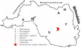
This diagram shows the position of this parish within the county of Glamorgan - click on this to see a full size diagram of the county
|
Parish map (Kain/Oliver)
You can see maps centred on OS grid reference SS989854 (Lat/Lon: 51.558391, -3.459756), Peterston super Montem which are provided by:
- OpenStreetMap
- Google Maps
- StreetMap (Current Ordnance Survey maps)
- OpenStreetMap Cymru (Welsh counties only)
- Bing (was Multimap)
- Old Maps Online
- National Library of Scotland (Old Ordnance Survey maps)
- Vision of Britain (Click "Historical units & statistics" for administrative areas.)
- Magic (Geographic information) (Click + on map if it doesn't show)
- GeoHack (Links to on-line maps and location specific services.)
- All places within the same township/parish shown on an Openstreetmap map.
- Nearby townships/parishes shown on an Openstreetmap map.
- Nearby places shown on an Openstreetmap map.
Places, villages, farms etc within Peterston-super-Montem as shown on the online parish map from the CD of Historic Parishes of England and Wales: an Electronic Map of Boundaries before 1850 with a Gazetteer and Metadata [computer file]. (Kain, R.J.P., Oliver, R.R.). (Extracted by Glenys Travis)
- Peterston super Montem [85]; - Argoed Edwin, Brynna Gwynion, Brynna, Mill, Coed bychan, Hendre-wen, Llwyn y brain, Mynydd Coed-bychan, Mynydd Hugh, Mynydd Maendy, Mynydd Portref, Nant Llanilid, Tyn-y coed, Tyn-y-cwm.
The Population of Peterston-super-Montem was as follows, and a more detailed breakdown is available.
| 1841 - 166 | 1851 - 185 | 1861 - 216 | 1871 - 198 | 1881 - 241 | 1891 - 301 |