
Hide
--- TEST SYSTEM --- TEST SYSTEM --- TEST SYSTEM ---
Hide
Llangiwg
hide
Hide
hide
Hide
hide
Hide
Hide
"LLAN CIWG, in the Cwmwd of Derfedd, Cantref of Ffiniog (now called the Hundred of Llan Gefelach), Co. of GLAMORGAN, South Wales: a Perpetual Curacy, not in charge: Patron, John Herbert Lloyd, Esq.: Church ded. to St. Ciwg. The Resident Population of this Parish, in 1801, (including the Hamlets Allt Grûg, and Parcel Mawr) was 491. The Money raised by the Parish Rates, in 1803, was, viz., For the Hamlet Allt Grûg £ 20.7.6, For the Parcel Mawr £101.4.9, (total) £121.12.3 at 13s. in the pound. It is 6 m. N.W. from Neath. This Parish contains about 15,000 acres of Land; of which, about one half is inclosed and cultivated. It abounds with Iron ore, stone Coal, and Culm; great quantities whereof are conveyed by the Canal to Swansea, and exported to different parts of the Kingdom. According to the Diocesan Report, in 1809, the yearly value of this Benefice, arising from Augmentation, fixed Stipend, and Surplice Fees, was £51.10.0. "(From: A Topographical Dictionary of The Dominion of Wales by Nicholas Carlisle, London, 1811)
Hide
Here is a substantial reading list of books which relate to Glamorgan, either county or parish.
1871 census - Llangiwg and Ystradgynlais parishes - Includes master indexes and full transcriptions, originally transcribed by the Ystradgynlais Family History Society
1891 census for Pontardawe Registration District - originally transcribed by the Glamorgan Family History Society
Description of Caegurwen hamlet based on the 1871 census - by Gareth Hicks. Now included here
Census place names in 1861 These are place/farm names extracted for Llangiwg parish Enumeration Districts from the Glamorgan Family History Society 1861 census index. Now included here
See the Cwmgors/Waun site for a database of local chapels and churches Now included here
1851 Religious census; here is an extract of data relating to Llangiwg parish's church/chapels
See Welsh Chapels and Churches for photographs of various churches/chapels in this parish
Rees, Thomas & Thomas, John. Hanes Eglwysi Annibynnol Cymru. (History of the Welsh Independent Churches), 4 volumes 1871+.
- There are the (Welsh) extracts from this book relating to Rhydyfro and the Gwrhyd ; and Carmel, GCG - all three have translations by Eleri Rowlands
- Pantteg now added, with translation by Maureen Saycell; Cwmllynfell now added - translation by Eleri Rowlands
- Gurnos now added ; also Y Wern, Ystalyfera; & Ystalyfera (Saesonig); & Glantwrch in BRE (with translations by Maureen Saycell)
Llangiwg Parish Church - on the People's Collection Wales site
For full and up-to-date details of their holdings see the sites of Glamorgan Record Office and/or West Glamorgan Archives
See Bap/Mar/Bur data on FreeReg
The church is dedicated to St. Ciwg, is in the Benefice of Llangiwg (Pontardawe), and Diocese of Swansea and Brecon. Details of the present incumbent of this benefice can be found at the Church in Wales website. The church can be located at grid reference SN723056.
| Anglican Parish Registers Held at the Glamorgan Record Office, Cardiff | ||||
| Baptisms | Marriages | Burials | Banns | Bishops Transcripts |
| 1703-1767, 1813-1892 | 1704-1859 | 1703-1767, 1813-1881 | 1823-1861 | 1672, 1677, 1682-1683, 1685-1686, 1690, 1693, 1696-1697, 1701-1702, 1704, 1707-1708, 1711-1713, 1725, 1727-1728, 1730-1734, 1736-1752, 1754-1779, 1782-1795, 1797-1800, 1802-1803, 1805-1835, 1839-1842, 1844, 1846-1847, 1851-1856, 1858, 1863, 1866 (At the National Library of Wales, Aberystwyth) |
Details of extant records on Archives Network Wales for the following;
- Llangiwg Ecclesiastical Parish Records "Registers (including service and banns registers) 1703-1988; licences 1859-1868; Churchwardens' accounts and correspondence 1882-1942; papers relating to church buildings 1887-1954; Vestry minutes 1773-1815; Highway rates 1859; papers relating to church school 1856-1947; church histories 1963 and c. 2001"
"Dedicated to St Ciwg. Ancient parish, out of which was created the parish of Ystalyfera in 1911. Includes St Peter's, Pontardawe (built 1858-1862 by William Parsons, and consecrated 1862) and St Mary's, Ynysmeudwy (built 1913, sponsored originally by Mrs Illtyd Thomas of Glanmor, Swansea, and finished by her daughter, Mrs F. W. Gilbertson). All Saints, Pontardawe, originally built by Arthur Gilbertson in memory of his father William as a chapel of ease in the parish of St John, Clydach in 1886, was transferred to Llangiwg parish in 1903"
Modern Parishes & Chapels of Ease :-
- St. Peter, Pontardawe - Chapel of ease to Llangiwg
- St. Mary, Ynysmeudw
- St. David, Ystalyfera - Chapel of ease to Llangiwg, formed into a parish in 1903
- Holy Trinity, Godregraig
- Gwauncaegurwen - Chapel of ease to Llangiwg
The following Religious Institutions are covered in the Mormon International Genealogical Index (IGI) :-
- Llangiwg, St. Ciwg - Christenings (BT's), 1813-1866
Aerial photographs of Penlle'r castell on the People's Collection Wales site (use search box)
Aerial photograph of Brynaman, 2001 - on the People's Collection Wales site
Brynaman - on Wikipedia
Local Railways Now included here
Transcript of complete name listing for Llangiwg, from Slaters Directory for 1871.
Kelly's Directory South Wales 1910 The data extracted relates to the villages of Lower Brynamman, Cwmgors, Gwauncaegurwen, and Rhydyfro and Llanguicke parish in general with the exception of Pontardawe and Ystalyfera which have their own sections on the CD .
Kelly's Directory South Wales 1895 for the 'Swansea Valley', this extract covers only the villages of Lower Brynamman, Cwmgors, Gwauncaegurwen, Rhydyfro and Llanguicke parish in general
The Swansea Directory (Purriers) for 1913 - the complete book is viewable on the Internet Archive - has Pontardawe, Clydach, Ystalyfera and Amman Valley trades sections
Kelly's Directory of South Wales 1923 for Llangiwg parish - covers Lower Brynamman, Cwmgors, Gwauncaegurwen, Rhydyfro, Tairgwaith,Ynysmudw and the parish in general
Jones, Bill & Dr Huw Walters. On the American Frontiers: Amman Valley Emigrants in Texas, 1879-1880. The Carmarthenshire Antiquary, 37/2001.
The transcription of the section for Llangiwg from The National Gazetteer (1868) provided by Colin Hinson.
Description of parish from A Topographical Dictionary of Wales (1833) by Samuel Lewis.
- Ask for a calculation of the distance from Llangiwg to another place.
Local people of note Now included here
Local wills Now included here
The James family of Godre'r Garth farm, Rhydyfro A photograph and story on the Welsh Family History Archive site
Some of the hamlets, towns and villages within this parish
|
|
Local Timeline Now included here
Rhydyfro - An excerpt from the book The History of Pontardawe by John E Morgan [Hirfryn] 1911. Translated by Ivor Griffiths. Now included here
Details of extant records on Archives Network Wales for the following;
- W D Williams collection "Lecture notes, 1923 including notes for a lecture concerning the history of Ystalyfera 1923, notes for a lecture on the old industries of Ystalyfera undated (?1920s) notes for a lecture on the history of the Parish of Llangiwg undated (?1920s) and a notebook recording the contents of other copybooks and notebooks undated (?1920s"
Lewis. Joshua. History of y Gwrhyd, 1897. Index by Gareth Hicks
Davies, John Henry. The History of Pontardawe and District , 1967. Index by Gareth Hicks. This book has a wide coverage of the parish and outside its borders.
Evans, Hywel Gwyn. Twenty 20 Memories Carmarthenshire County Council, 2006. A collection of personal memories of people who live(d) in the villages of Brynaman, Cefn-bryn-brain, Cwmllynfell, Cwm-twrch, Pant-teg, Rhiw-fawr and Ystradowen Introduction, Contents listing, and list of photographs
Rees, Enoch. The History of Brynamman 1883 & 1896. (Trans. from the original Welsh by Ivor Griffiths, Gorseinon.) Here is an index for the English version, with contents listing, and an index for the Welsh version, both by Anna Brueton
Thomas, Hugh. THE INDUSTRIALIZATION OF A GLAMORGAN PARISH (Llangiwg). National Library of Wales journal Winter, 1975, Vol XIX/2 . pp 194-208. A complete extract of the first of three articles.
Thomas, Hugh. THE INDUSTRIALIZATION OF A GLAMORGAN PARISH (Llangiwg). National Library of Wales journal Summer,1976, Volume XIX/3. pp 227-242. A complete extract of the second of three articles.
Thomas, Hugh. THE INDUSTRIALIZATION OF A GLAMORGAN PARISH (Llangiwg). National Library of Wales journal Winter,1976, Volume XIX/4. pp 345-361. A complete extract of the final of three articles.
See here for particular references of interest
Farms in the area generally Now included here
Local lettings and easements Now included here
Details of extant records on Archives Network Wales for the following;
- Cilybebyll estate papers 1497-1954 "The Cilybebyll estate was small and compact, made up for the most part of lands in the southern and central parts of the parish of Cilybebyll and neighbouring parts of Blaenhonddan to the west of Alltwen, and farms near Pontardawe in the parishes of Llangiwg and Llangyfelach. The estate also owned Cwmtwrch Farm in Carmarthenshire, near the foot of the Black Mountain. Whereas some estates could boast continuous ownership by one family over several centuries, tenure of the Cilybebyll estate was rather more complicated................................."
Quitclaim, 15 June 1516, (i) Retherghe ap Jevan ap Morgan, to (ii) Morgan ap Jevan ap Glin Thomas. Tenement in supraboscus of Gower called e Cleyn Gwyn, lying between the River Twrch on north, land of Jankyn Thomas Echan on south, Gweyn Nicoll on west, and Bryn Etowyn on east; in Llangiwg. [Written in Latin]. - on the People's Collection Wales site
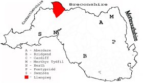
This diagram shows the position of this parish within the county of Glamorgan - click on this to see a full size diagram of the county
|
Parish map (Kain/Oliver)
You can see maps centred on OS grid reference SN730089 (Lat/Lon: 51.76447, -3.841138), Llangiwg which are provided by:
- OpenStreetMap
- Google Maps
- StreetMap (Current Ordnance Survey maps)
- OpenStreetMap Cymru (Welsh counties only)
- Bing (was Multimap)
- Old Maps Online
- National Library of Scotland (Old Ordnance Survey maps)
- Vision of Britain (Click "Historical units & statistics" for administrative areas.)
- Magic (Geographic information) (Click + on map if it doesn't show)
- GeoHack (Links to on-line maps and location specific services.)
- All places within the same township/parish shown on an Openstreetmap map.
- Nearby townships/parishes shown on an Openstreetmap map.
- Nearby places shown on an Openstreetmap map.
Census place names in 1861 These are place/farm names extracted for Llangiwg parish Enumeration Districts from the Glamorgan Family History Society 1861 census index. Now included here
Places, villages, farms etc within Llangiwg parish as shown on the online parish map from the CD of Historic Parishes of England and Wales: an Electronic Map of Boundaries before 1850 with a Gazetteer and Metadata [computer file]. (Kain, R.J.P., Oliver, R.R.). (Extracted by Gareth Hicks)
- Llangiwg (8); Afon Twrch; Beili glas; Betting; Blaen-egel-fawr; Blaen-nant; Blaen nant-hir; Bryn Cwmllynfell; Brynamman (Lower); Bryn-llefrith; Bryn-melyn; Carn Lwyd; Crach llwyn; Craig Llangiwg; Cwmgors; Cwmllynfell; Cwm-nant-Hopkin; Cwm-nant-Lleiky; Cwrt-y-bariwns; Fforch-egel Hosp.; Garth; Gellifowy; Gelli-gron; Gelli-lwca-fawr; Gelli-warog; Gilfach-yr-haidd; Godre'r-graig; Gwaun-Cae-Gurwen; Gwaun-Leision; Gwrhyd; Hendre-Forgan; Llangiwg; Llwyn-hen; Mynydd Allt-y-grug; Mynydd Bach; Mynydd Uchaf; Mynydd-y-Garth; Nant-y-gaseg; Pen-how; Pen-twyn; Pen-rhiw-fawr; Pen-y-daren; Pen-y-dderi; Pen-y-lan; Penllerfedwen; Pistyll-gwyn; Pontardawe; Rhyd-y-fro; River Egel; River Tawe; Swansea Canal; Tyle Penlan; Ynys-meudwy; Ystalyfera; Ystrad-Owen
Nicknames from the mines of the Tairgwaith district on the Coal Mining page - contributed by Roy Davies, Now included here
Llais Llafur
- The Llais Llafur was a weekly newspaper edited, printed and published at Ystalyfera in the upper reaches of the Swansea Valley between 1898 and 1971. ..............With the help of the Heritage Lottery Fund, the Ystradgynlais Family History Society is having the complete run of the newspaper put on to microfilm and deposited in Ystradgynlais Library ........" (Oct 2007)
The NLW have now digitised the newspaper which can be viewed on https://newspapers.library.wales/browse/3977363
Issue dates: 3 January 1914 – 27 December 1919 (311 available issues) (Sept 2014)
The Llais
- In February 2008 the 300th issue of the 'Llais' - the Swansea Valley Welsh language monthly newspaper- will be printed. This will be the 30th year of its existence and since it's inception monthly copies have been lodged at the National Library of Wales Aberystwyth as have all other 'papurau bro' (local area publications) produced throughout Wales.
The paper is a non commercial publication, run by local volunteers, and is distributed locally by hand and by post to various subscribers world wide. The area covered by the publication includes all the Swansea Valley villages from Penycae and Cwmllynfell in the north to Clydach and Graigcefnparc as well as Rhos and Rhydyfro. Relevant information and photographs is collected by and submitted by individual volunteers in every village. Schools and other organisations also provide information and the organisers are always pleased to receive any new submissions from any source.
The Llais organisation, as part of its 30th anniversary celebrations, will be producing a Calendar for 2008 which will include old photographs of the region.
Abernant Colliery on the Welsh Coal Mines site
Coal mining in Gwauncaegurwen and Cwmgors and local area [Includes Extracts from History of Pontardawe book] and has details of an accident at Garnant Colliery on Wednesday, January 16, 1884. Now included here
Coal and Tinplate related extracts from The History of Brynamman By Enoch Rees 1883/1896. Translated by Ivor Griffiths. Now included here
Gellilwca Fawr from the south, taken 2004. Occupied by Thomas Howell from 1772 and then by his son Howell Llewlyn from 1800-1850. Owned by the Shewin family and later by J. D. Berrington as late as 1832. Formerly part of the Duke of Beaufort's estate. - on the People's Collection Wales site
The Farmers Arms, Brynamman. A feature on the Jones family who ran it in the C19th. Now included here
The first edition of the News of the World newspaper dated 1 October 1843 carries a report summarised as follows;
A meeting of farmers has been held at Cwm Twrch ............ between 500 and 1000 farmers and others with Mr John Jones of Bryn Amman elected to the chair......... called with a view to try and discover the causes from which so much distress pervaded the whole county, why it was that so many of the people found it so difficult to obtain a living. Speakers included; Mr B Allen, farmer;Mr Williams, farmer; Mr H Herbert, farmer. The main points at issue were; tithes - paying one sixth against the one tenth they 'ought to pay, blamed the Commutation Act. Also rents were raised because they competed against each other when farms came up for rent. Also the restrictions on imports which brought about higher rents and kept the price of land high. Also the 'infamous poor laws which were most unnatural' leading to higher rates on the farmers with too much going to 'management expenses'. They wished 'these laws to be abolished, and corn laws also' - A petition to the Queen was ultimately agreed, embodying the above sentiments.
The Population of Llangiwg was as follows, and a more detailed breakdown is available.
| 1841 - 2,813 | 1851 - 4,229 | 1861 - 7,983 | 1871 - 8,312 | 1881 - 9,110 | 1891 - 9,707 |
Details of extant records on Archives Network Wales for the following;
- Llangiwg Parish Council and Pontardawe Community Council Records " ....... including minute books, 1894-1897; poor rate books, 1849-1914; vestry minutes, 1855-1887; tithe plan and apportionment, 1842; Pontardawe Community Council videos, 1995"
Gymanfa Ganu etc Data from booklets relating to events in the 1930s/1940s in Cwmgors, GCG & Pontardawe. And now included here
Schools/Education in Llangiwg parish Now included here
Details of extant records on Archives Network Wales for the following;
- Gwrhyd School (closed in 1906) "Log book, 1890-1906, of Gwrhyd School"
- Rhydyfro elementary school (opened in 1877) " ..... comprising log book (mixed and infants), 1877-1931; admission register, 1877-1911; centenary booklet, 1977"
Walters, Huw. Cynnwrf Canrif : Agweddau Ar Ddiwylliant Gwern. Cyhoeddiadau Barddas, Abertawe, 2004. ISBN: 1900437678. Paperback, 372p.
A comprehensive collection of eight interesting and informative essays reflecting various aspects of the rich folk culture of the Aman and other south Wales valleys in the 19th century, written by a thorough researcher. Here is a review of the book by Tegwyn Jones (in Welsh)
Tairgwaith Workingmen's Club. A group photograph on the Picture Gallery - some names
Local people of note Now included here
Rugby Scrapbook Now included here
Pontardawe & District Operatic Society Newspaper report from the late 1930s. Also Saron (Rhydyfro) Operatic Society report. Now included here
Extract from the article re Ebenezer Independent Chapel, Swansea taken from Hanes Eglwysi Annibynnol Cymru. By Thomas Rees and John Thomas; published in 1871+.
Referring to Mr Davies, Llangeler, the minister there;
"The moral attitude in Swansea was utterly wretched when Mr. Davies started his ministry here. ........................ He had such an influence over the common people within a few years, that just his appearance was enough to quieten the most arrogant ungodly people. Take these facts as examples: - There were several butchers from the area of Cwmaman and Llangiwc who held a market in Swansea. Every Saturday evening some of them, when they'd finished selling their meat, would go to the public houses, and would drink there until Sunday morning, when they started for home on their little horses. As they went out of the town, if they happened to meet Mr. Davies coming towards them on the road, they would go back until they found a crossroads to turn into....................." Full article on Genuki