
Hide
--- TEST SYSTEM --- TEST SYSTEM --- TEST SYSTEM ---
Hide
Gelligaer
hide
Hide
hide
Hide
hide


Hide
Hide
"GELLI GAER, in the Cwmwd of Senghenydd, Cantref of Brenhinol (now called the Hundred of Caerphilly), Co. of GLAMORGAN, South Wales: a Rectory valued in the King's Books at £20..7..11: Patron, The Marquis of Bute: Church dedicated to St. Cadog. The Resident Population of this Parish, in 1801, (consisting of the Hamlets of Brith dir, Cefn, Garth Gynyd, Hen Coed, and Ysgwydd Wyn) was 1051. The Money raised by the Parish Rates, in 1803, was, £391..13..5, at 7s. in the pound. It is 14 m. N. b. W. from Caerdiff. A Fair for Cattle is holden here on the 3d of April. ...................................... " (A Topographical Dictionary of The Dominion of Wales by Nicholas Carlisle, London, 1811.)
Hide
Here is a substantial reading list of books which relate to Glamorgan, either county or parish.
References to Gelligaer in the British Library
The Glamorgan Family History Society have produced a set of microfiche containing Monumental Inscriptions for the following burial grounds :-
- Parish Church of St. Cattwg
Visit their website for information on how to purchase.
| St Catwg, Gelligaer, Church in Wales |
The Glamorgan Family History Society have produced a set of microfiche containing an enumerated transcription and a personal name index. These are available for the years :
- 1841 - (included in with Merthyr Tydfil)
- 1851 - HO107/2457
Chapels Database - a list of all known non-conformist chapels or other non-Anglican religions in the parish
See Welsh Chapels and Churches for photographs of various churches/chapels in this parish
Various items - on the People's Collection Wales site
- St Catwg's Church
- Photograph of Gelligaer Church and site of Roman camp, taken by Ronald Reynolds in the early 20th century.
For full and up-to-date details of their holdings see the sites of Glamorgan Record Office and/or West Glamorgan Archives
See Bap/Mar/Bur data on FreeReg
The church is dedicated to St. Catwg, is in the Benefice of Gelligaer, and the diocese of Llandaff. Details of the present incumbent of this benefice can be found at the Church in Wales website. The church can be located at grid reference ST135969.
| Anglican Parish Registers Held at the Glamorgan Record Office, Cardiff | ||||
| Baptisms | Marriages | Burials | Banns | Bishops Transcripts |
| 1707-1800, 1813-1933 | 1707-1929 | 1707-1800, 1813-1922 | - | 1696, 1717-1718, 1724-1800, 1802-1809, 1811-1812, 1814-1815, 1817-1837 |
Details of extant records on Archives Network Wales for the following;
- Gelligaer Ecclesiastical Parish records " ........... including registers of baptisms,1813-1933; marriages, 1754-1929; burials, 1866-1922; indexes to marriage and burials registers; terriers, 1699-1866; records relating to glebe, 1808-1935; churchwardens accounts, 1816-1915; Brithdir chapelwardens account, 1853-1868; records of St. Margaret's church, 1907-1932; church restoration records, 1926-1932; civil parish and miscellaneous records, 1887-1920; extracts from missing parish registers: burials, 1708-1793; baptisms, 1759-1800"
Modern Parishes & Chapels of Ease :-
- Gelligaer St. Anne
- St. Gwladys, Bargoed
- St. Cadoc, Bedlinog
- St. David, Brithdir
- St. Aidan, Bute Town
- St. Peter, Deri
- St. Mary and St. Andrew, Fochriw
- St. Margaret, Gilfach
- St. Michael, New Tredegar
- St. Tyfaelog, Pontlottyn - Parish formed in 1870 from Gelligaer
- St. Cynon, Treharris - Chapel of ease to Llanfabon, joined Treharris, St. Matthias in 1951
- St. Matthias, Treharris - Parish formed in 1900 from Merthyr Tydfil and Gelligaer
- Holy Trinity, Ystrad Mynach
The following Religious Institutions are covered in the Mormon International Genealogical Index (IGI) :-
- Gelligaer, St. Cattwg - Christenings (BT's), 1813-1870
- Gelligaer, Craig y Bargoed Independent - Christenings, 1829-1837
- Gelligaer, Craig y Bargoed Non Conformist - Christenings, 1832-1838
Various landscapes - on the People's Collection Wales site
The transcription of the section for Gelligaer from The National Gazetteer (1868) provided by Colin Hinson.
- A Topographical Dictionary of Wales (1833) by Samuel Lewis.
- A Topographical Dictionary of The Dominion of Wales by Nicholas Carlisle, London, 1811
- Ask for a calculation of the distance from Gelligaer to another place.
Details of extant records on Archives Network Wales for the following;
- Lewis family of Trelewis, Gelligaer, records 1601-1928 "On the 1841 tithe map and apportionment for Gelligaer, Bontnewydd is recorded as a 60 acre farm in the possession of Daniel Lewis. During the nineteenth century, this area became known as Trelewis, a small mining community which depended for employment on the neighbouring Deep Navigation Colliery..............."
Some of the hamlets, towns and villages within this parish
|
|
Details of extant records on Archives Network Wales for the following;
- T. V. Davies Research Papers "Research papers of Professor T. V. Davies, [c.1981]-1991, into the farms and farmers of Senghenydd Supra in the parishes of Gelligaer and Merthyr Tydfil....................... draft chapters; papers relating to the Llantrisant and District Local History Society, 1981-1990; .................and typescripts of his lectures to history societies, 1988-1989"
Various items - on the People's Collection Wales site
- This colourful mosaic sits in the centre of Gelligaer, oppositie St Catwg's Church.
- Model of the stone fort at Gelligaer in the early 2nd century AD.
- Photograph of Gelligaer Church and site of Roman camp, taken by Ronald Reynolds in the early 20th century.
Jones, Judith. Gelligaer and Merthyr Common: A South Wales landscape Past and Present. 2003.
"Gelligaer and Merthyr Common occupies nearly 8,000 acres of upland in north-east Glamorgan between the Rhymney and Taff valleys. Man has used this land more or less continuously since prehistoric times and has left his mark in many ways. It has been used for agriculture, encroached upon for housing and industry, and until modern times was administered through manorial courts by a succession of great landowners who held the lordship of Glamorgan.This new book, whose author is herself a commoner, summarises the history and archaeology of the common, it discusses how both the landscape of the common and the local farming community, who depend on the traditional common rights for their livelihood, can survive pressure from adjoining urban areas and from abuse of the land such as the dumping of rubbish and cars. It also discusses current changes in attitudes to commons.The book will be of interest not only to local historians and residents of the district but to anyone concerned with the future of the upland landscapes of Wales."
Details of extant records on Archives Network Wales for the following;
- Gelligaer, Gelliargwellt deeds "Deeds relating to Gelliargwellt, Gelligaer, 1700-1823; deeds and miscellaneous documents relating to Tylaglas, in Gelligaer, and Mynyddislwyn (Monmouthshire), 1733-1900."
- Perrott and Richards families, of Gelligaer and Bedwas, deeds and papers "Deeds and papers relating to Hengoed Hall and other property in Gelligaer, 1744-1798; deeds relating to Smith's forge and other property in Gelligaer, 1793-1800; deeds, legal and probate papers relating to the Perrott family, 1834-1947; record of births and deaths of the Jones family of Gelligaer, 1829-1855; and papers of Richards family of Gwernau Ganol and Gwernau Fawr, Bedwas (Monmouthshire), 1853-1955."
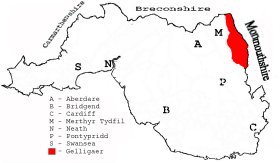
This diagram shows the position of this parish within the county of Glamorgan - click on this to see a full size diagram of the county
|
Parish map (Kain/Oliver)
You can see maps centred on OS grid reference SO118027 (Lat/Lon: 51.71646, -3.277874), Gelligaer which are provided by:
- OpenStreetMap
- Google Maps
- StreetMap (Current Ordnance Survey maps)
- OpenStreetMap Cymru (Welsh counties only)
- Bing (was Multimap)
- Old Maps Online
- National Library of Scotland (Old Ordnance Survey maps)
- Vision of Britain (Click "Historical units & statistics" for administrative areas.)
- Magic (Geographic information) (Click + on map if it doesn't show)
- GeoHack (Links to on-line maps and location specific services.)
- All places within the same township/parish shown on an Openstreetmap map.
- Nearby townships/parishes shown on an Openstreetmap map.
- Nearby places shown on an Openstreetmap map.
Places, villages, farms etc within Gelligaer as shown on the online parish map from the CD of Historic Parishes of England and Wales: an Electronic Map of Boundaries before 1850 with a Gazetteer and Metadata [computer file]. (Kain, R.J.P., Oliver, R.R.). (Extracted by Gareth Hicks)
- Brithdir (75A); Ysgwyddgwyn (75B); Garth-Gynyd (75C); Cefn (75D); Hengord (75E);
Bargoed (village); Bedlinog (village); Bedlinog Colliery; Blaen-carno; Blaenllwynau; Blaen Rhymney; Brithdir; Bute Town; Capel Grolad..?(remains); Carn Bugail; Cascade Ho.; Cefn Gelligaer; Cem.; Cefn-bach; Cefn-llwynau; Cefn y Brithdir; Clawdddrawscae; Coed Deri Newydd; Colliery(7); Coly Row; Cwm Bargoed; Cwmfelin; Cwm-llywdrew Fm.; Darran Colliery; Darran & Deri Sta.; Deri (village); Ffochriw (village); Fforest Gwladys; Gelliaur-gwellt-uchaf; Gelligaer (village); Gelligaer Common; Gilfach (village); Gilfach-maen-uchaf; Golf Course; GWR Dowlais & Llancaiach; GWR Rhymney Valley; Great Western Railway; Groes-faen-isaf; Hen-dai; Hengoed; Heol Adam; Heol-ddu-uchaf; Hospl.; Iron Works; Llancaiach; Llan-uchaf; Maen T..?; Maerdy; Mynydd Ffochriw; Nant Caiach; Pant-y-waun(2); Penalltau; Pen-heol-Adam; Pen March; Pen-pedair-heol; Pen-twyn; Pen-y-bank; Pen-y-garreg; Pit; Pits (near Cwm Bargoed Sta.); Pontlottyn (village); Pont Newydd; Pont Seison; Quarry(2); Reservoir(4); Rhaslas Pond; Rhos-yr-yrfa; Rhymney Bridge Sta.; Rhymney Reservoir; Roman Road; School; Sebastopol; Tir-Phil (village); Tir-y-felin; Tophill; Traed -y-Milwyr; Trelewis (village); Tunnel (near Cwm Bargoed Sta.); Twyn-giden; Twyn-y-Fid-ffawydd; Twyn-y-waun; Tyla-du Plantation; Tyla-glas; Waun Rydd; Y Darren, Ystrad Mynach.
Various items - on the People's Collection Wales site
- Aerial photograph of Gelligaer Quarry. Taken on 09 June 2006
- View of Penallta colliery looking from SW, oblique aerial view. "Penallta Colliery was built by the Powell Duffryn Steam Coal Company in 1906-09 and was one of the last steam-powered collieries constructed, although it did also generate its own electricity. In 1910 huge difficulties were experience while opening out the Red Vein due to faulting. By the early 1930s the colliery employed over 3,000 and was achieving an annual production figure of over 860,000 tons."
- Gelligaer Local Labour Party
1940-49: minutes
[University of Swansea Library - Reference: SWCC]
The Population of Gelligaer was as follows, and a more detailed breakdown is available.
| 1841 - 3,215 | 1851 - 3,807 | 1861 - 5,778 | 1871 - 9,193 | 1881 - 11,592 | 1891 - 12,754 |
Details of extant records on Archives Network Wales for the following;
- Gelligaer and Rhigos Rural District Council records 1898-1908
- Gelligaer Civil Parish records 1750-1925 " .......... including perambulation, 1750; receipt for tax collected, 1799; order to petty constable, 1821; highway surveyors' papers, 1821-1822; list of ratepayers, 1828; agreement to lease charity lands, 1840; overseers' appointment, 1844; vestry minutes book, 1865-1925; overseers' rate books, 1856-1894; valuation lists, 1868-1885; sanitary rates, 1877-1879; survey of sanitary conditions, c1860; highway rates, 1859-1879; tithe plan and apportionment, 1842"
- Gelligaer Urban District Council records 1910-1974
Details of extant records on Archives Network Wales for the following;
- Gelligaer School Board records " .......... comprising minute books, 1890-1903; ledgers, 1898-1903; minutes of managers of Pontlottyn Schools, 1871-1885"
Memorial to the first Lewis school - Edward Lewis left money in his will specifically for setting up a school. He died in 1728 at only 37 years of age. The school was to benefit 15 poor boys of the Parish at any one time, and the sum he left was to cover the cost of purchasing a building, paying a teacher and to provide for uniforms and other materials. As his mother outlived him, it was a condition of his will that his wishes could not be put in to force until she too had died. Finally on the 1st August 1762 the school was opened in a small cottage near the site of the Roman Fort. - on the People's Collection Wales site