
Hide
--- TEST SYSTEM --- TEST SYSTEM --- TEST SYSTEM ---
Hide
Ingoldisthorpe
hide
Hide
hide
Hide
hide


Hide
Hide
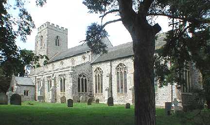
"INGOLDISTHORPE, on the Hunstanton road, 10 miles N.N.E. of Lynn, is a small scattered village, seated in a picturesque vale, finely clothed with wood, and watered by a small rivulet, which flows westward across the salt marshes to the Wash, after forming a beautiful cascade at the new bridge, near Snettisham. The parish contains 344 inhabitants, and 1,128 acres of land, mostly belonging to John Bellamy, Esq., of Wisbech, the lord of the manor, who has a large mansion here, now occupied by the Rev. Edward Bellamy, M.A. On an eminence, commanding an extensive view of the ocean and the adjacent country, is Mount Amelia, the delightful seat of Captain John Davy, R.N., built by John Davy, Esq., in 1745. . . . The CHURCH (St. Michael,) is a large building with a square tower and three bells, and opposite the south porch stands an ancient cross. The rectory, valued in the King's Book at £12, and in 1831 at £355, has 45 acres of glebe. Certain Trustees are patrons, and the Rev. Abm. Hepworth, LL.B., is the incumbent." [William White, History, Gazetteer, and Directory of Norfolk (1845) - Transcription copyright © Paul Beesley]
Hide
The name may also be spelled Ingoldesthorpe.
Hide
- 1891: Surname List (this is a link to an archived copy)
See also Norfolk Parish Links: Censuses
- In 1883 the parish was in the Deanery of Heacham, in the archdeaconry of Norfolk.
It could have been in a different deanery or archdeaconry both before and after this date. - The parish church is dedicated to St Michael.
- Church of St Michael
- Description and pictures.
- Church of St Michael
- Picture of the church.
- The Church
- Ingoldisthorpe: the Church of St. Michael.
[Ingoldisthorpe, The Church, 1960s]
- Marriages 1754-1837
- See Phillimore's Marriage Registers, Volume 12.
- Marriages
- These are included in Boyd's Marriage Index.
See also Norfolk Parish Links: Church Records
For the civil registration of births, marriages and deaths between 1837 and 1930 (and for the censuses from 1851 to 1901), Ingoldisthorpe was in Docking Registration District.
- Howard, Richard G.
- A Survey of Ingoldisthorpe.
[Typescript in Norwich Local Studies Library, 1964] - King's Lynn Arts Centre.
- Portrait of a Village: Ingoldisthorpe.
[ISBN 1898328013, West Norfolk Living Histories, 1993]
- Ask for a calculation of the distance from Ingoldisthorpe to another place.
Ingoldisthorpe is in Smithdon Hundred.
- Parish outline and location.
- See Parish Map for Smithdon Hundred
- Description of Smithdon Hundred
- 1845: White's History, Gazetteer, and Directory of Norfolk
- Great Britain: Statute
- Annual Inclosure Act, 1856.
An act to authorize the inclosure of certain lands in pursuance of a report of the Inclosure Commissioners for England and Wales: 11th April 1856.
(The schedule refers to 29 locations, amongst which is the parish of Ingoldisthorpe in Norfolk, for which a provisional inclosure order was made on 2 August 1855).
[London, George Edward Eyre and William Spottiswoode, 1856]
You can see maps centred on OS grid reference TF687328 (Lat/Lon: 52.866591, 0.505026), Ingoldisthorpe which are provided by:
- OpenStreetMap
- Google Maps
- StreetMap (Current Ordnance Survey maps)
- Bing (was Multimap)
- Old Maps Online
- National Library of Scotland (Old Ordnance Survey maps)
- Vision of Britain (Click "Historical units & statistics" for administrative areas.)
- English Jurisdictions in 1851 (Unfortunately the LDS have removed the facility to enable us to specify a starting location, you will need to search yourself on their map.)
- Magic (Geographic information) (Click + on map if it doesn't show)
- GeoHack (Links to on-line maps and location specific services.)
- All places within the same township/parish shown on an Openstreetmap map.
- Nearby townships/parishes shown on an Openstreetmap map.
- Nearby places shown on an Openstreetmap map.
- After 1834 Ingoldisthorpe became part of the Docking Union, and the workhouse was at Docking.