
Hide
--- TEST SYSTEM --- TEST SYSTEM --- TEST SYSTEM ---
Hide
Filby
hide
Hide
hide
Hide
hide


Hide
Hide
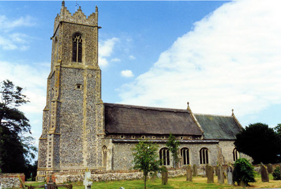
"FILBY is a small parish and straggling village, on the Norwich turnpike, 6 miles N.W. of Yarmouth. It has 553 inhabitants, and 1191 acres of land, exclusive of roads, 100A. in plantations, and about 160A. in a fine lake, called Filby Broad, and abounding with fish and wild ducks. The Church, dedicated to All Saints, has a lofty embattled tower and five bells. It stands on an eminence above the lake, and contains a beautiful marble monument, in memory of the late Chas. Lucas, Esq. The rectory, valued in the King's Books at £11. 1s. 6d., and in 1831, at £520, has 24 acres of glebe, and is in the patronage of the Rev. Charles Lucas, and incumbency of the Rev. Gibson Lucas, who is also chief owner and lord of the manor, which was anciently held by a family of its own name. Filby House, the seat of the rector, is a handsome mansion of white brick, rebuilt in 1833." [William White, History, Gazetteer, and Directory of Norfolk (1845) - Transcription copyright © Pat Newby]
Hide
See also Wilby.
Hide
- Church of All Saints
- Transcriptions of gravestones in the churchyard.
See also Norfolk Parish Links: Cemeteries
- 1891: Surname List (this is a link to an archived copy)
See also Norfolk Parish Links: Censuses
- In 1883 the parish was in the Deanery of Flegg, in the archdeaconry of Norwich.
It could have been in a different deanery or archdeaconry both before and after this date. - The parish church is dedicated to All Saints.
- Church of All Saints
- Description and pictures.
- Church of All Saints
- Services, picture, etc.
- Church of All Saints
- Services, etc.
- Church of All Saints
- Picture of the church.
- Tooke, Colin S.; and Saul, Joan
- Filby Dissenters Chapel, 1705-1940.
[1992] - Filby Unitarian Chapel (this is a link to an archived copy)
- Description, history and pictures of the site.
- Tooke, Colin S.
- Filby Unitarian Chapel.
[Great Yarmouth, Great Yarmouth and District Archaeological Society, in "Yarmouth Archaeology", 1995]
- Baptisms, marriages and burials
- Search the Flegg Island web pages.
- Parish Register Transcripts
- Baptisms 1813-1880
- Marriages 1561-1837
- See Phillimore's Marriage Registers, Volume 7.
- Marriages
- These are included in Boyd's Marriage Index.
See also Norfolk Parish Links: Church Records
For the civil registration of births, marriages and deaths between 1837 and 1923 (and for the censuses from 1851 to 1901), Filby was in Flegg Registration District. Between 1837 and 1850, the district was called East and West Flegg.
- Filby Village
- Events, parish council, newsletter, organisations, etc.
- 1845: White's History, Gazetteer, and Directory of Norfolk
- 1850: Hunt's Directory of East Norfolk with Part of Suffolk
- 1883: White's History, Gazetteer, and Directory of Norfolk
- 1883: Kelly's Directory for Cambridgeshire, Norfolk and Suffolk (this is a link to an archived copy)
See also Norfolk Parish Links: Directories
- Ask for a calculation of the distance from Filby to another place.
Filby is in East Flegg Hundred.
- Parish outline and location.
- See Parish Map for East Flegg and West Flegg Hundreds
- Description of East Flegg and West Flegg Hundreds
- 1845: White's History, Gazetteer, and Directory of Norfolk
- Skelton, Philip N.
- Historical Notes on the Manors of Filby, Norfolk.
[Norfolk, King's Lynn, Filby Association, 1975]
- Great Britain: Statute
- Filby Inclosure Act, 1802.
An act for dividing, allotting, and inclosing, the open fields, commons, doles, and waste grounds, within the parish of Filby in the county of Norfolk.
[1802]
- Faden's Map of Norfolk 1797
- Extract, showing Filby.
You can see maps centred on OS grid reference TG471136 (Lat/Lon: 52.663734, 1.652581), Filby which are provided by:
- OpenStreetMap
- Google Maps
- StreetMap (Current Ordnance Survey maps)
- Bing (was Multimap)
- Old Maps Online
- National Library of Scotland (Old Ordnance Survey maps)
- Vision of Britain (Click "Historical units & statistics" for administrative areas.)
- English Jurisdictions in 1851 (Unfortunately the LDS have removed the facility to enable us to specify a starting location, you will need to search yourself on their map.)
- Magic (Geographic information) (Click + on map if it doesn't show)
- GeoHack (Links to on-line maps and location specific services.)
- All places within the same township/parish shown on an Openstreetmap map.
- Nearby townships/parishes shown on an Openstreetmap map.
- Nearby places shown on an Openstreetmap map.
- War Memorial
- World Wars 1 and 2.
- Filby
- See Norfolk People and Families
- After 1775 Filby became part of the East and West Flegg Incorporation, and the workhouse was at Rollesby.
These figures are from the population tables which were produced after the 10-yearly national censuses. The "Families" heading includes families and single occupiers.
|
|
There may be more people living in detached parts of the parish (if there were any) and, if so, the number may or may not be included in the figures above. It is quite difficult to be sure from the population tables.