
Hide
--- TEST SYSTEM --- TEST SYSTEM --- TEST SYSTEM ---
Hide
Scopwick
hide
Hide
hide
Hide
hide
Hide
Hide
“SCOPWICK, a parish in the second division of Langoe wapentake, parts of Kesteven, county Lincoln, 9 miles N. of Sleaford, its post town, and 10 S.W. of West-Kirtstead railway station. The village, which is of small extent and chiefly agricultural, is situated on the road from Lincoln to Sleaford. The Burton bounds meet in this parish. The soil is light and sandy, with a substratum of limestone, which is quarried for building purposes. A little to the W. of the village is a heath, sheltered on the E. by some oak woods. The tithes were commuted for corn rents under an Enclosure Act in 1797, and the glebe comprises 16 acres. The living is a vicarage* in the diocese of Lincoln, value £185, in the patronage of the bishop. The church, dedicated to the Holy Cross, is a comparatively modern edifice, having been rebuilt upwards of half a century back, with the exception of the tower. The register dates from 1609. There is a Church school. The Wesleyans have a place of worship. H. Chaplin, Esq., is lord of the manor."
”
from The National Gazetteer of Great Britain and Ireland - 1868
Hide
This place is serviced by a Mobile Library which currently visits every 4 weeks (28 days).
- David HITCHBORN has a photograph of part of the Cemetery on Geo-graph, taken in August, 2013 .
- The parish was in the Billinghay sub-district of the Sleaford Registration District.
- Check our Census Resource page for county-wide resources.
- The table below gives census piece numbers, where known:
| Census Year | Piece No. |
|---|---|
| 1841 | H.O. 107 / 622 |
| 1861 | R.G. 9 / 2341 |
| 1871 | R.G. 10 / 3348 |
| 1881 | R.G. 11 / 3221 |
| 1891 | R.G. 12 / 2577 |
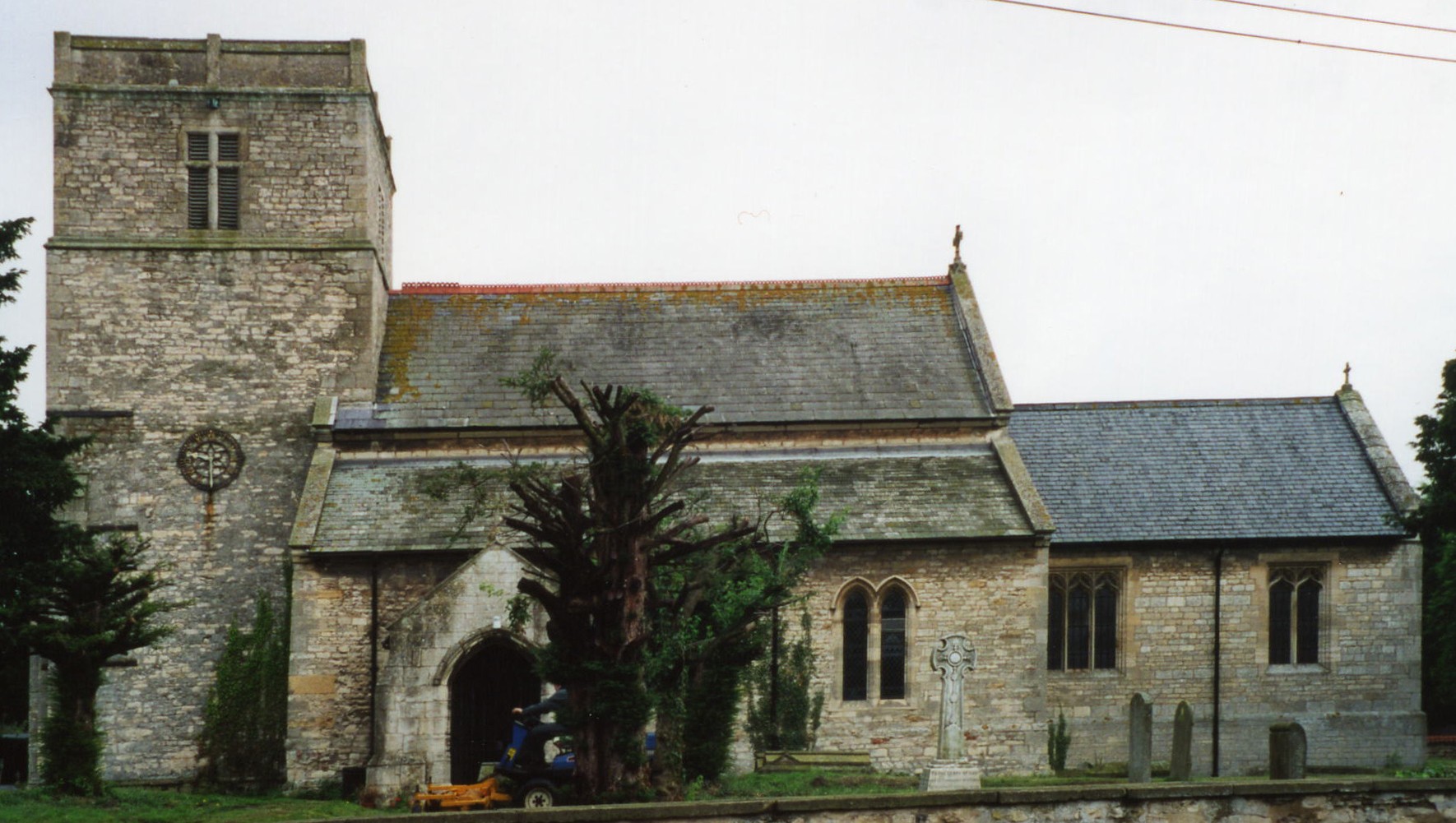
- The Anglican parish church is dedicated to the Holy Cross.
- The church was renovated in 1908. There are several ancient monuments to the SEWELL family inside.
- The church seats about 200.
- There is a photograph of Holy Cross church on the Wendy PARKINSON Church Photos web site.
- Here is a photo of Holy Cross Church, taken by Ron COLE (who retains the copyright):
- Anglican parish register entries start in 1695, but Bishop's transcripts go back to 1562.
- Shelly CLACK provides a list of names from the churchyard memorials. This is a Portable Document File.
- The parish lies in the Graffoe Deanery, for which several marriage indexes exist.
- The Wesleyan Methodists built a small chapel here in 1905. For information and assistance in researching these chapels, see our non-conformist religions page.
- Richard CROFT provides a photograph of the Wesleyan Methodist chapel on Geo-graph, taken in 2006.
- Check our Church Records page for county-wide resources.
- The parish was in the Billinghay sub-district of the Sleaford Registration District.
- Check our Civil Registration page for sources and background on Civil Registration which began in July, 1837.
This village and parish is nine miles north of Sleaford and eleven miles southeast of Lincoln. The parish of Temple Bruer lies to the west, Rowston lies to the south and Blankney to the north. A small stream, the Scopwick Beck, runs along the south edge of the parish on its way to join the River Witham. The parish covers some 3,400 acres of heath land.
The ecclesistical parish of Scopwick includes the civil parish of Kirkby Green.
If you are planning a visit:
- Take the A153 trunk road north out of Sleaford, turn north at Ruskington onto the B1198 and follow that into Scopwick. Alternatively, you can take the A15 north from Sleaford and turn right onto the B1191 and go past Ashby de la Launde into Scopwick. The B1191 and the B1198 cross at Scopwick.
- Visit our touring page for more sources.
- You'll know when you are getting close. Alex McGREGOR provides a photograph of the Sign! on Geo-graph, taken in 2011.
The National Gazetteer of Great Britain and Ireland - 1868
- Ask for a calculation of the distance from Scopwick to another place.
- Scopwick was part of the large sheep farming operation of Temple Bruer in Norman times. This is the probable origin of the parish name (see below).
- The national grid reference is TF 0758.
- You'll want an Ordnance Survey Explorer map, which has a scale of 2.5 inches to the mile.
- See our Maps page for additional resources.
You can see maps centred on OS grid reference TF070581 (Lat/Lon: 53.109535, -0.403147), Scopwick which are provided by:
- OpenStreetMap
- Google Maps
- StreetMap (Current Ordnance Survey maps)
- Bing (was Multimap)
- Old Maps Online
- National Library of Scotland (Old Ordnance Survey maps)
- Vision of Britain (Click "Historical units & statistics" for administrative areas.)
- English Jurisdictions in 1851 (Unfortunately the LDS have removed the facility to enable us to specify a starting location, you will need to search yourself on their map.)
- Magic (Geographic information) (Click + on map if it doesn't show)
- GeoHack (Links to on-line maps and location specific services.)
- All places within the same township/parish shown on an Openstreetmap map.
- Nearby townships/parishes shown on an Openstreetmap map.
- Nearby places shown on an Openstreetmap map.
- The Royal Flying Corps opened an airfield here in 1917. In March, 1918, just a few days before becoming the Royal Air Force, the field was designated RAF Scopwick.
- Because the name was similar to another airfield, RAF Scopwick was renamed RAF Digby in April, 1920.
- RAF Digby was used for training pilots and crew from 1920 through 1937.
- RAF Digby then became a Sector Fighter Airfield in August, 1937, becoming the home of 12 Group Fighter Command.
- The first combat sortie was scrambled on 3 September, 1939.
- The Royal Canadian Air Force arrived in December, 1940, as the Winnipeg Squadron.
- In September, 1942, RAF Digby became Royal Canadian Air Force Station Digby.
- After the war ended, RAF Digby became part of RAF College Cranwell and returned to its role as a training base.
- Although flight operations ended in 1953, this is still an active RAF station (as of 2011).
- Linda MELLOR provides a photograph of the Military graves and War Memorial on Geo-graph, taken in May, 2004.
- Julian P. GUFFOGG has a photograph of the tombstone of John Gillespie MAGEE on Geo-graph, taken in May, 2015.
- For a list of war dead, check the Scopwick War Dead web page.
- The name Scopwick combines Old English sceap with Old Scandinavian wic, for "sheep farm". In the 1086 Domesday book, the village is given as Scapeuic.
[A. D. MILLS, "A Dictionary of English Place-Names," Oxford University Press, 1991]
- Here's a partial list of surnames found in White's 1871 Directory: ALVEY, BAGGALEY, BARTHOLOMEW, BAUMBER, BLACK, BONNER, BOOTH, CATTON, CHALLANS, CHRISTIAN, CLARK, COLLINSON, FULLALOVE, GEORGE, HALL, HANSON, HARRISON, HURD, MERRYWEATHER, METHRINGHAM, MITTON, PACEY, PEARS, PELL, PORTAS, SALTER, SCHOLEY, TAYLOR, WATSON, WHITE and WRIGHT.
- Kelley's 1913 Directory lists these surnames: ATKIN, BAGALEY, BAUMBER, BROWN, CHRISTIAN, CODLING, DOOLING, COULSON, CUTLER, FLINTHAM, FULLALOVE, FORD, GIBSON, HARRISON, HICKS, MACKINDER, MERRYWEATHER, OGDEN, POUCHER, ROSSINGTON, SALTER, SCHOLEY, SHARPE, SMITH, SPENCER, SWAN, TAYLOR, WATSON and WILKINSON.
- This place was an ancient parish in county Lincoln and became a modern Civil Parish when those were established.
- The parish was in the ancient Langoe Wapentake in the North Kesteven division of the county, in the parts of Kesteven.
- In April, 1931, Kirkby Green was abolished as a parish and amalgamated with Scopwick Civil Parish.
- For today's governance, see the North Kesteven District Council.
- Bastardy cases would be heard in the Sleaford petty session hearings every Monday.
- As a result of the 1834 Poor Law Amendment Act, the parish became part of the Sleaford Poor Law Union.
- A Public Elementary School was built here in 1866 on a site given by Henry CHAPLIN, Member of Parliament, to be used by children from Scopwick and Kirkby Green parishes. Designed for 90 children, average attendance in 1913 was 70.
- For more on researching school records, see our Schools Research page.