
Hide
--- TEST SYSTEM --- TEST SYSTEM --- TEST SYSTEM ---
Hide
Little Ponton
hide
Hide
hide
Hide
hide


Hide
Hide
hide
Hide
“PONTON PARVA, (or Paunton, Little), a parish in the wapentake of Winnibriggs, parts of Kesteven, county Lincoln, 3 miles S. of Grantham, its railway station and post town. The village, which is of small extent, is situated on the Great North road, near the bank of the river Witham, and is wholly agricultural. Limestone and freestone are quarried. The tithes were commuted for land and corn rents under an Enclosure Act in 1811, and there are 26 acres of glebe. The living is a rectory* in the diocese of Lincoln, value £336. The church, dedicated to St. Guthlac, is a very ancient structure, and partly pulled down in 1657. The Hall is a stone edifice situated in the midst of pleasure-grounds. C. Tumor, Esq., is lord of the manor and sole landowner.
”
from The National Gazetteer of Great Britain and Ireland - 1868
Hide
Use the Grantham Public Library in the Isaac Newton Centre, Grantham. They are typically open six days per week.
- Robert HARVEY has a wide photograph of the Churchyard at St. Guthlac on Geo-graph, taken in September, 2018.
- Alexander KAPP also has a photograph of the Churchyard on Geo-graph, taken in May, 2012.
- The parish was in the Denton sub-district of the Grantham Registration District.
- In an 1891 redistricting, the parish was put in the Grantham South sub-district of the Grantham Registration District.
- Check our Census Resource page for county-wide resources.
- The table below gives census piece numbers, where known:
Census
YearPiece No. 1841 H.O. 107 / 621 1851 H.O. 107 / 2102 1861 R.G. 9 / 2348 1871 R.G. 10 / 3357 1891 R.G. 12 / 2583
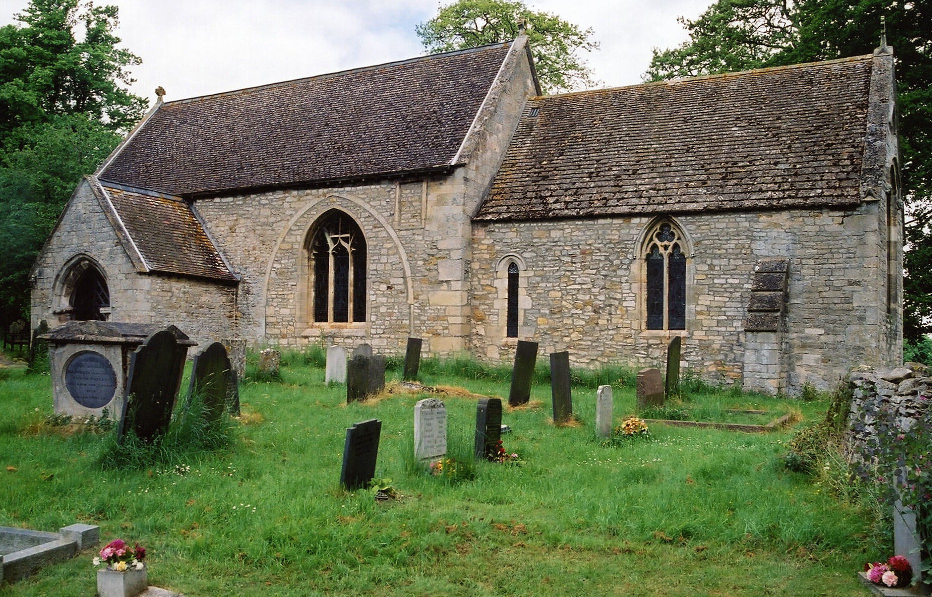
- The local Anglican church is dedicated to Saint Guthlac and is of Anglo-Norman origin.
- St. Guthlac's seated 190.
- The west wall was rebuilt in 1657 and a new roof installed in 1870.
- In 1913, the seating was about 150.
- At the enclosure of Common Lands in 1811 or 1813, about 200 acres were set aside to generate income for the church.
- Around 1880, due to the growth of Grantham, the church was moved to the new Grantham Deanery. And by 1913, to the South Grantham Deanery. Most family records will be found in the Beltisloe Deanery indexes (see below).
- Here is a photo of St. Guthlac's, taken by Ron COLE (who retains the copyright):
- The Anglican parish register dates from 1729.
- There are monuments in the church to members of the PENNYMAN and THOROLD families.
- The Lincolnshire FHS has published several marriage and burial indexes for the Beltisloe Deanery to make your search easier.
- Check our Church Records page for county-wide resources.
- The parish was in the Denton sub-district of the Grantham Registration District.
- In an 1891 redistricting, the parish was put in the Grantham South sub-district of the Grantham Registration District.
- Check our Civil Registration page for sources and background on Civil Registration which began in July, 1837.
Little Ponton is both a parish and a small village about 2 miles south of Grantham. The parish itself is bounded on the north by Spittlegate parish and to the west by Stroxton parish. Great Ponton lies to the south. The parish covered about 1,895 acres in 1842, reduced to 1,420 acres by 1871. In 1913, the parish boundaries allowed 1,980 acres.
Little Ponton is a small village and does not appear on some small scale (large area) maps of the UK. The village verges on the Witham River on the east end. If you are planning a visit:
- Kate JEWELL has a photograph of a Street scene in Little Ponton on Geo-graph, taken in August, 2005.
- The village can be accessed off of the A1 motorway south of Grantham where it meets the B1174 trunk road.
- A new South Grantham bypass was authorized in 2018 and may affect local acess until it is completed.
- David DIXON has a photograph of the A1 offramp to Little Ponton on Geo-graph, taken in August, 2014.
- Visit our touring page for more sources.
The National Gazetteer of Great Britain and Ireland - 1868
- Ask for a calculation of the distance from Little Ponton to another place.
- The village was held by the Romans as a military station, at least based on the number of Roman coins, urns, arches, etc. found in the parish.
- When the railways came in the second half of the 1800s, it bypassed Little Ponton. Residents used the train station at Great Ponton.
- Little Ponton had a water pumping station, part of the Grantham Water Works, around 1900.
- Grange Farm's buildings date from 1866 and are Grade II structures with English Heritage. Tim HATON has a photograph of the farm buildings on Geo-graph, taken in September, 2020.
- Little Ponton Hall, or the Hall as it was known, was a neat stone mansion in well-wooded grounds on an eastern rise, occupied in the early 1800s by the Earl of Darlington, later given the title of the Duke of Cleveland. Although portions were built at different times, by different owners, the appearance was kept uniform.
- In 1900, the Hall was the residence of Major William LONGSTAFFE. The major was born in Gedney, LIN, circa 1832. He was an officer in the 2nd Volunteer Battalion Lincolnshire Regt. He was 69 years old in the 1901 census. His household include 8 servants. The major was married on 18 Feb. 1884 in Stoke Rochford, LIN, to Selina Laura TURNOR. He died on 5 Jan. 1922 in the Grantham Reg. Dist.
- Brian GREEN has a photograph of the Lodge of Little Ponton Hall on Geo-graph, taken in February, 2008.
- See our Maps page for additional resources.
You can see maps centred on OS grid reference SK925321 (Lat/Lon: 52.878455, -0.627165), Little Ponton which are provided by:
- OpenStreetMap
- Google Maps
- StreetMap (Current Ordnance Survey maps)
- Bing (was Multimap)
- Old Maps Online
- National Library of Scotland (Old Ordnance Survey maps)
- Vision of Britain (Click "Historical units & statistics" for administrative areas.)
- English Jurisdictions in 1851 (Unfortunately the LDS have removed the facility to enable us to specify a starting location, you will need to search yourself on their map.)
- Magic (Geographic information) (Click + on map if it doesn't show)
- GeoHack (Links to on-line maps and location specific services.)
- All places within the same township/parish shown on an Openstreetmap map.
- Nearby townships/parishes shown on an Openstreetmap map.
- Nearby places shown on an Openstreetmap map.
- The name Ponton presumably comes from the Latin for "bridge," which was "Pontus".
- The village name is often found spelled as Paunton, or the Latin form was used, "Paunton Parva".
- This place was an ancient parish in Lincoln county and became a modern Civil Parish when those were established.
- The parish was in the ancient Winnibriggs and Threo Wapentake in the South Kesteven district in the parts of Kesteven.
- In April, 1931, this Civil Parish was abolished and amalgamated with Stroxton to create the new "Little Ponton and Stroxton" Civil Parish.
- You may contact the local Parish Council regarding civic or political issues, but they are not staffed to answer family history questions.
- For today's district governance, contact the South Kesteven District Council.
- Bastardy cases would be heard in the Spitalgate petty session hearings.
- The Common Lands were enclosed in 1811 or 1813, and about 200 acres were set aside to generate income for the church.
- As a result of the Poor Law Amendment Act reforms of 1834, the parish became part of the Grantham Poor Law Union.
Probate was held on 17 Jun 1922 on the will of William LONGSTAFFE. His only beneficiary was Christopher Hatton TURNOR.
- A school was built by subscription in 1832 by the Rev. Dr. DOWDISWELL who was Lord of the Manor at the time.
- The Public Elementary School was enlarged in 1884 to accomodate 56 children, but attendance in 1913 was only 27.
- For more on researching school records, see our Schools Research page.