
Hide
--- TEST SYSTEM --- TEST SYSTEM --- TEST SYSTEM ---
Hide
Wavertree
hide
Hide
Hide
hide
Hide
hide


Hide
Hide
WAVERTREE, a village, a township, two chapelries, and a sub-district, in Childwall parish and West Derby district, Lancashire. The village stands 1½ mile SE of Edgehill r. station, and 3 ESE of Liverpool; has been much improved under a local board of health; is a place of resort for invalids; and has a post-office under Liverpool, a police station, public baths, and a reading room. The township comprises 1,796 acres. Real property, £36,743; of which £66 are in quarries. Pop. in 1851, 4,011; in 1861, 5,392. Houses, 910. The manor belongs to the Marquis of Salisbury. There are numerous good residences, two churches, a free church of 1869, two dissenting chapels, a Roman Catholic chapel, two national schools, two large breweries, and an extensive ropery. The two chapelries are Holy Trinity and St. Mary; and the former is a p. curacy, the latter a rectory, in the diocese of Chester. Value of each, £300. Patron of the former, the Vicar of Childwall; of the latter, the Bishop of Chester. The sub-district contains 4 townships. Acres, 7,448. Pop. in 1851, 7,415; in 1861, 10,845. Houses, 1,792.
John Marius Wilson, Imperial Gazetteer of England and Wales (1870-72)
Hide
Local studies information is held at Liverpool library.
Details about the census records, and indexes for Wavertree.
| Hunter's Lane Congregational, Wavertree |
| Elm Hall Drive, Wesleyan Methodist, Wavertree |
| Wellington Ave, Wavertree, Wesleyan Methodist |
| Wesley Wesleyan Methodist, Wavertree |
| Wavertree Bethel Welsh Presbyterian Lancashire |
| Woolton Road, Presbyterian, Wavertree |
The Register Office covering the Wavertree area is Liverpool.
The National Gazetteer of Great Britain and Ireland - 1868
"WAVERTREE, a township in the parish of Childwall, hundred of West Derby, county Lancaster, 3 miles S.E. of Liverpool, its post town, and 1½ mile from Edgehill railway station. The village is situated on the Grand Junction canal. There are rope works and an extensive brewery. In the vicinity is an ancient well with a Latin inscription, bearing date 1414. The soil is loamy and sandy, with a subsoil of red sandstone and marl. The living is a perpetual curacy in the diocese of Chester, value £117, in the patronage of the Vicar of Childwall. The church is dedicated to the Holy Trinity. There is also St. Mary's church, erected in 1853. There are National schools for both sexes, including infants, and a Sunday-school. The Independents, Wesleyans, and Roman Catholics have each a chapel. The Marquis of Salisbury is lord of the manor."
- Ask for a calculation of the distance from Wavertree to another place.
In 1835 Wavertree was a township in the parish of Childwall.
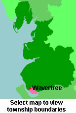
View a map of the boundaries of this town/parish.
You can see maps centred on OS grid reference SJ394887 (Lat/Lon: 53.391778, -2.913282), Wavertree which are provided by:
- OpenStreetMap
- Google Maps
- StreetMap (Current Ordnance Survey maps)
- Bing (was Multimap)
- Old Maps Online
- National Library of Scotland (Old Ordnance Survey maps)
- Vision of Britain (Click "Historical units & statistics" for administrative areas.)
- English Jurisdictions in 1851 (Unfortunately the LDS have removed the facility to enable us to specify a starting location, you will need to search yourself on their map.)
- Magic (Geographic information) (Click + on map if it doesn't show)
- GeoHack (Links to on-line maps and location specific services.)
- All places within the same township/parish shown on an Openstreetmap map.
- Nearby townships/parishes shown on an Openstreetmap map.
- Nearby places shown on an Openstreetmap map.
For probate purposes prior to 1858, Wavertree was in the Archdeaconry of Chester, in the Diocese of Chester. The original Lancashire wills for the Archdeaconry of Chester are held at the Lancashire Record Office.
You can also see Family History Societies covering the nearby area, plotted on a map. This facility is being developed, and is awaiting societies to enter information about the places they cover.