
Hide
--- TEST SYSTEM --- TEST SYSTEM --- TEST SYSTEM ---
Hide
Uplyme
hide
Hide
hide
- Almanacs◬
- Archives & Libraries◬
- Bibliography◬
- Biography◬
- Business & Commerce Records◬
- Cemeteries
- Census
- Chronology◬
- Church History
- Church Records
- Churches
- Civil Registration◬
- Correctional Institutions◬
- Court Records◬
- Description & Travel
- Directories◬
- Emigration & Immigration◬
- Encyclopaedias & Dictionaries◬
- Folklore◬
- Gazetteers
- Genealogy◬
- Handwriting◬
- Heraldry◬
- Historical Geography◬
Hide
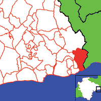
Click on map to view parish boundaries in detail.
Hide
Hide
hide
- History
- Jewish History◬
- Land & Property◬
- Language & Languages◬
- Manors◬
- Maps
- Medical Records◬
- Merchant Marine◬
- Military History◬
- Names, Geographical◬
- Names, Personal
- Newspapers◬
- Occupations◬
- Periodicals◬
- Politics & Government◬
- Poor Houses, Poor Law◬
- Population◬
- Probate Records
- Schools
- Social Life & Customs◬
- Societies◬
- Taxation◬
- Voting Registers◬
Hide
"UPLYME, a large scattered village, is pleasantly situated at the most eastern extremity of Devon, only about a mile N.W. of the town and sea-port of Lyme-Regis, in Dorsetshire. Its parish is a suburb of that town, and comprises 1057 inhabitants, and 3149A. 2R. 5P. of land. The manor was anciently held by Glastonbury Abbey, and afterwards passed to the Drake and Tucker families. The Hon. Sir John Talbot, K.C.B., admiral of the Blue, is now lord of the manor and owner of a great part of the parish. He has a handsome seat here called Rhode Hill House. Robert Bourchier Wrey, Esq., of Ware Cliff House; James Davidson, Esq., and the Rev. C.W. Ethelston, M.A., have estates in the parish. The latter is also patron and incumbent of the rectory, valued in K.B. at £20. 8s. 11½d., and in 1831 at £386. The glebe is 35A., and the Rectory House is a handsome residence, which was enlarged and much improved in 1838, when the tithes were commuted for £461. The CHURCH (St. Peter and St. Paul,) is an ancient structure, with a remarkably low tower. The Methodists and Baptists have chapels here. . . . " [From White's Devonshire Directory (1850)]
A parish in Axminster Hundred, and the Archdeaconry and Diocese of Exeter.
Hide
MIs for this parish are included in the Incledon index - see under Cemeteries on the main Devon page.
Matthews, A.W. Ye Old Mortality. vol. 8 (1909) pp. 868-893. [MS, Society of Genealogists]
Watkin, Alfred (ed.). The Great Chartulary of Glastonbury Abbey, vol. 3. Somerset Record Society 64 (1956). [Raymond: Includes property at Uplyme.]
Parish Registers going back to 1684 are held in the Devon Record Office.
The Devon FHS publishes indexes covering (as of June 2004): Baptisms 1813-1839, Marriages 1754-1838, Burials 1813-1837 - for details see their Devon Parish List.
Other churches and chapels (with pre-1840 records):
- Wesleyan Chapel: Registers for c1809-37 - see Axminster (PRO RG 4/512)
Nothing entered into the IGI (as of Jan 1993).
The Deanery of Honiton: CD-ROM CD041, Exeter, Devon FHS (2013). [Axminster Bapt: 1813-1840, Mar: 1754-1837, Bur: 1813-1837; Axmouth Bapt: 1813-1840, Mar: 1603-1837, Bur: 1813-1837; Chardstock Bapt: 1813-1839, Mar: 1754-1837, Bur: 1813-1837; Colyton Bapt: 1813-1839, Mar: 1538-1837, Bur: 1813-1837; Combpyne Bapt: 1813-1839, Mar: 1757-1836, Bur: 1796-1847; Cotleigh Bapt: 1813-1839, Mar: 1754-1837, Bur: 1813-1837; Dalwood Bapt: 1813-1840, Mar: 1754-1837, Bur: 1813-1837; Farway Bapt: 1813-1840, Mar: 1754-1837, Bur: 1800-1837; Gittisham Bapt: 1813-1839, Mar: 1754-1838, Bur: 1800-1837; Hawkchurch Bapt: 1813-1839, Mar: 1754-1837, Bur: 1813-1838; Honiton Bapt: 1813-1839, Mar: 1754-1837, Bur: 1813-1837; Honiton Ind, Bur: 1774-1837; Kilmington Bapt: 1813-1839, Mar: 1754-1837, Bur: 1813-1837; Membury Bapt: 1813-1840, Mar: 1754-1837, Bur: 1813-1837; Monkton Bapt: 1813-1839, Mar: 1754-1837, Bur: 1814-1842; Musbury Bapt: 1813-1839, Mar: 1754-1837, Bur: 1813-1837; Northleigh Bapt: 1813-1839, Mar: 1756-1836, Bur: 1813-1837; Offwell Bapt: 1813-1839, Mar: 1754-1837, Bur: 1800-1837; Seaton & Beer Bapt: 1813-1839, Mar: 1754-1839, Bur: 1813-1837; Shute Bapt: 1813-1840, Mar: 1754-1837, Bur: 1813-1837; Southleigh Bapt: 1813-1839, Mar: 1756-1837, Bur: 1800-1837; Stockland Bapt: 1813-1840, Mar: 1640-1837, Bur: 1813-1837; Thorncombe Bapt: 1813-1837, Mar: 1754-1837, Bur: 1813-1841; Uplyme Bapt: 1813-1839, Mar: 1754-1838, Bur: 1813-1837; Wambrook Bapt: 1813-1904, Mar: 1754-1836; Widworthy Bapt: 1813-1840, Mar: 1754-1954, Bur: 1790-1837.]
Section on Uplyme from Samuel Lewis: A Topographical Dictionary of England (1831), provided by Mel Lockie.
Uplyme Village Design Statement and Parish Plan, from East Devon District Council.
Stirling, D.M. Beauties of the Shore: or A Guide to the Watering Places on the South East Coast of Devon. Comprising copious illustrations of the Antiquities, History, Topography and Scenery of the following parishes; Seaton, Axmouth, &c. &c., Exeter, W. Roberts (printer) (1838) vi + 191pp + 6pp list of subscribers + 3 pages of adverts. [Index]
The transcription of the section for this parish from the National Gazetteer (1868), provided by Colin Hinson.
- Ask for a calculation of the distance from Uplyme to another place.
Berry, Les. Around Uplyme and Lyme Regis. (Archive photographs series) Chalford: Chalford Publishing (1995) 128p: chiefly ill. [ISBN 0752400444]
Gosling, Gerald and Thomas, Jack. The Book of Uplyme: Portrait of a Devonshire Village, Halsgrove (2004) 160 p. [ISBN 1841143359]
The story of Uplyme. Uplyme Women's Institute (1982) 27p: ill, map. [Westcountry Studies - pB/UPL/0001/STO]
View a map of the boundaries of this town/parish.
You can see maps centred on OS grid reference SY325935 (Lat/Lon: 50.737172, -2.957907), Uplyme which are provided by:
- OpenStreetMap
- Google Maps
- StreetMap (Current Ordnance Survey maps)
- Bing (was Multimap)
- Old Maps Online
- National Library of Scotland (Old Ordnance Survey maps)
- Vision of Britain (Click "Historical units & statistics" for administrative areas.)
- English Jurisdictions in 1851 (Unfortunately the LDS have removed the facility to enable us to specify a starting location, you will need to search yourself on their map.)
- Magic (Geographic information) (Click + on map if it doesn't show)
- GeoHack (Links to on-line maps and location specific services.)
- All places within the same township/parish shown on an Openstreetmap map.
- Nearby townships/parishes shown on an Openstreetmap map.
- Nearby places shown on an Openstreetmap map.
Uplyme contributors to a 1678 brief for the rebuilding of St Paul's Cathedral.
Will of Johnathan otherwise Jonathan Ostler (1849), provided by Ros Dunning.
Children sent to Day School (1827), transcribed by Jenni Gay.