
Hide
--- TEST SYSTEM --- TEST SYSTEM --- TEST SYSTEM ---
Hide
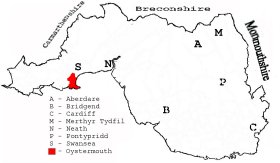
Oystermouth
hide
Hide
hide
Hide
hide
Hide
Hide
"A seaside resort on the west side of Swansea Bay, better known from its outstanding islets as the Mumbles. The village possesses a pier and the picturesque ruins of a castle. Beyond the headland are Langland and Caswell Bays, two favourite bathing places." [Glamorganshire, 1911]
"OYSTERMOUTH, a parish in the hundred of Swansea, county Glamorgan, 4 miles S.W. of Swansea, its post town, and 10 from Llanelly. The village is situated on the Bristol Channel. It is a bathing place, and has considerably increased of late years. The parish contains the villages of Mumbles, Newton, and Norton. Seated on an eminence, backed up by a huge cliff of limestone, are the ruins of Oystermouth Castle, which was founded by Henry Beaumont, or Richard de Granville, in the 11th century. A portion of the ruins have been restored at the expense of the Duke of Beaufort. .......(more below) [The National Gazetteer of Great Britain and Ireland 1868] by Colin Hinson ©2018]
Hide
Here is a substantial reading list of books which relate to Glamorgan, either county or parish.
- Oystermouth Railway & Tramroad Company
- 1804-55: parliamentary and legal papers, ledgers, journals, accounts, correspondents
[University of Swansea Library] - 19th-20th cent: misc papers
[West Glamorgan Archive Service, Swansea - Reference: D/D SB/9]
- 1804-55: parliamentary and legal papers, ledgers, journals, accounts, correspondents
The Glamorgan Family History Society have produced a set of microfiche containing Monumental Inscriptions for the following burial grounds :-
- Parish Church of All Saints
| Cemetery Chapel, Oystermouth |
| Castleton Independent Chapel, Mumbles |
| Paraclete Congregational Chapel, Newton |
| Tabernacle Independent Chapel, Mumbles |
| Cemetery Chapel, Oystermouth |
| Methodist Chapel, Oystermouth |
| Victoria Hall Methodist Chapel, Oystermouth |
| Victoria Methodist Chapel, Mumbles |
| Our Lady Star of The Sea, Mumbles |
Chapels Database - a list of all known non-conformist chapels or other non-Anglican religions in the parish
See Welsh Chapels and Churches for photographs of various churches/chapels in this parish
An index to names in the book A history of All Saints' Church, Oystermouth, By Geoffrey R. Orrin and Dr. F. G. Cowley [1990] has been provided by Diana Davies. This index also contains a list of Incumbents.
Various items - on the People's Collection Wales site
- Oystermouth Church (1855-1860).
- A view of the Oystermouth Castle chapel with sheep grazing in the foreground.
For full and up-to-date details of their holdings see the sites of Glamorgan Record Office and/or West Glamorgan Archives
See Bap/Mar/Bur data on FreeReg
The church is dedicated to All Saints, is in the Benefice of Oystermouth, and diocese of Swansea and Brecon. Details of the present incumbent of this benefice can be found at the Church in Wales website. The church can be located at grid reference SS616879.
| Anglican Parish Registers Held at the National Library of Wales, Aberystwyth | ||||
| Baptisms | Marriages | Burials | Banns | Bishops Transcripts |
| 1719-1929 | 1719-1922 | 1719-1954 | 1824-1847 | 1671-1672, 1690, 1693, 1695-1697, 1700-1701, 1716, 1727-1761, 1763-1765, 1768-1786, 1788-1793, 1795, 1797-180, 1802-1803, 1805, 1808-1871 |
Modern Parishes & Chapels of Ease :-
The following Religious Institutions are covered in the Mormon International Genealogical Index (IGI) :-
- Oystermouth, All Saints - Christenings (BT's), 1813-1871
- Oystermouth, Paraclete Independent - Christenings, 1820-1836
The People's Collection Wales site has material for this parish, use the onsite search box
Oystermouth - on Wikipedia
Transcript of complete name listing for the Gower parishes, from Slaters Directory for 1880.
OYSTERMOUTH with the parishes of Bishopston, Cheriton, Ilston, Knelston, Llandewi, Llangennith, Llanmadoc, Llanrhidian (Higher & Lower), Nicholaston, Oxwich, Penmaen, Pennard, Penrice, Porteynon,
Reynoldston, Rhoscilly, and the villages of Horton, Kilibion, Mumbles, Park Mill, Penclawdd, Walterstone and West Cross.
The transcription of the section for Oystermouth from The National Gazetteer (1868) provided by Colin Hinson.
Descriptions of the parish from
A Topographical Dictionary of Wales (1833) by Samuel Lewis
A Topographical Dictionary of The Dominion of Wales by Nicholas Carlisle, London, 1811.
- Ask for a calculation of the distance from Oystermouth to another place.
Description and image of Oystermouth Castle at www.castlewales.com by Jeff Thomas
Various items - on the People's Collection Wales site
- Extract from the Manorial Court Rolls of Oystermouth & Pennard, 1662-76
- A view of the ruins of Oystermouth castle with a lighthouse in the background
- A view of the ruins of Oystermouth castle with Swansea bay below. Ships are in the sea.
- Oystermouth (1855-1860). Print created in 1934 from Francis Lockey's calotype negative.
MUMBLES LOCAL HISTORY CENTRE; Ty Hanes, 4, Dunns Lane, Mumbles, Swansea, SA3 4AA Tel: 01792 361012
Mondays, Wednesdays, Thursdays, Fridays and Saturdays from 10 a.m. to 4 p.m.
Exhibitions; Reference Section etc
This diagram shows the position of this parish within the county of Glamorgan - click on this to see a full size diagram of the county
|
Plan of Oystermouth in the County of Glamorgan - on the People's Collection Wales site
Parish map (Kain/Oliver)
You can see maps centred on OS grid reference SS608896 (Lat/Lon: 51.587623, -4.010954), Oystermouth which are provided by:
- OpenStreetMap
- Google Maps
- StreetMap (Current Ordnance Survey maps)
- OpenStreetMap Cymru (Welsh counties only)
- Bing (was Multimap)
- Old Maps Online
- National Library of Scotland (Old Ordnance Survey maps)
- Vision of Britain (Click "Historical units & statistics" for administrative areas.)
- Magic (Geographic information) (Click + on map if it doesn't show)
- GeoHack (Links to on-line maps and location specific services.)
- All places within the same township/parish shown on an Openstreetmap map.
- Nearby townships/parishes shown on an Openstreetmap map.
- Nearby places shown on an Openstreetmap map.
Places, villages, farms etc within Oystermouth parish as shown on the online parish map from the CD of Historic Parishes of England and Wales: an Electronic Map of Boundaries before 1850 with a Gazetteer and Metadata [computer file]. (Kain, R.J.P., Oliver, R.R.). (Extracted by Mary Greatorex)
- Oystermouth (45): Bellevue, Black-Pill, Bracelet Bay, Broadley, Cemetery, Coastguard Station, Clyne Castle, Clyne Common, Clyne Farm, Clyne Woods, Colliery, Colts Hill, Cwm bach, Deer Park, Golf Links, Grange Farm, Hotel, Langland Bay, Langland Farm, Lifeboat Station, Liliput, Limeslade, Mayals, Middle Head, Mumbles Head, Mumbles Hill, Newton, Newton Cliff, Norton, Oystermouth, Oystermouth Castle, Oystermouth Station, Rams Tor, Reservoir, Rothers Sker, Snaple Point, The Grange, The Gut, The Knab, The Mumbles, Thistleboon, Tutt, West Cross, Whiteshell Point, Whitestone.
The Population of Oystermouth was as follows, and a more detailed breakdown is available.
| 1841 - 1,482 | 1851 - 1,938 | 1861 - 2,460 | 1871 - 3,574 | 1881 - 3,915 | 1891 - 4,132 |
Details of extant records on Archives Network Wales for the following;
- Oystermouth Parish Council Records ".......... including rate books, 1870-1908; tithe plan, 1845; tithe apportionment, [late 20th century]."
- Oystermouth Urban District Council, records 1897-1915
Details of extant records on Archives Network Wales for the following;
- Oystermouth School Records " ........... including log books, 1878-1960; admission registers, 1878-1937; summary attendance registers, 1903-1921; special subjects registers, 1918-1919; correspondence, 1881-1939; plans, 1926; photographs, c.1890-1920."
- Oystermouth, later Blackpill, School Log Books 1879-1959