
Hide
--- TEST SYSTEM --- TEST SYSTEM --- TEST SYSTEM ---
Hide
Caerau (with Ely)
hide
Hide
hide
Hide
hide
Hide
Hide
See also under ELY
"CAERAU, in the Cwmwd of Cibwyr, Cantref of Brenhinol (now called the Hundred of Kibbor,) County of GLAMORGAN, South Wales: a Perpetual Curacy, not in charge: Patron, The Prebendary of Caerau in the Cathedral Church of Llandaff: Church dedicated to St. Mary. The Resident Population of this Parish, in 1801, was 65. The Money raised by the Parish Rates, in 1803, was £46..6..4, at 2s. 6d. in the pound. It is 3 m. W. from Caerdiff. This Parish, contains about 460 acres of inclosed Land, and about 40 acres of Wood. Here is an entire Roman Camp, within which the Church is situate. The Prebend of Caerau is valued in the King's Books at £3..10..7 1/2 ; and has the Tythes of Caerau and Penterry, and Llandogo, in the County of Monmouth. According to the Diocesan Report, in 1809, the yearly value of this Benefice, arising from Stipend, and Augmentation, was £35. " From: A Topographical Dictionary of The Dominion of Wales by Nicholas Carlisle, London, 1811.
"ELY is a hamlet attached in 1871 for ecclesiastical purposes to the parish of Caerau, and is 1 mile southwest, with a station on the Cardiff section of the Great Western railway, 158 miles from London. The church of St. David, a chapel of ease to Caerau, built in 1871, is a plain building of local stone, in the Gothic style, ... there are 230 sittings. The Rev. David Lewis Marsden B.A. of St. David's, Lampeter, and vicar of Caerau, officiates. A parish room was erected in 1897. There is a Wesleyan chapel, erected in 1910 at a cost of £3500, seating 750. Races are held here four times a year: there is a grand stand on the course. Two breweries and a jam factory are situated here. Llandaff and Dinas Powis Rural District Isolation Hospital was built in 1907 at a cost of £15,000, and will hold 32 patients." [From Kelly's South Wales Directory 1923 (ArchiveCDBooks) - transcribed by Gareth Hicks]
Hide
Here is a substantial reading list of books which relate to Glamorgan, either county or parish.
The Glamorgan Family History Society have produced a set of microfiche containing Monumental Inscriptions for the following burial grounds :-
- Parish Church of St. Mary
| St David, Ely, (Caerau with Ely) Church in Wales |
| St Mary the Virgin (ruin), Caerau (Church in Wales) |
| Ely South Baptist Chapel, Ely (Caerau with Ely) |
| Hope Baptist Chapel, Caerau (with Ely) |
| Noddfa Welsh Baptist Chapel, Caerau (with Ely) |
Friends of St Mary's Church, Caerau
Glamorgan Chapels Database - a list of all known non-conformist chapels or other non-Anglican religions in the parish.
Here are the references for one such chapel found but see also under Roath Chapels ;
- There is a Welsh Congregational Mission Hall [in Caerau]
Kelly's Directory, South Wales 1895 - the Archive CD Books Cd - There is an English Congregational Mission Hall [in Caerau]
Kelly's Directory, South Wales 1910 - the Archive CD Books Cd - There is a Dyffryn Ind chapel, Caerau, East Glamorgan shown as still open on the Union of Welsh Independents site (Dec 2006)
Various items - on the People's Collection Wales site
- Caerau Church exterior/Interior
- St Mary's Church at Caerau is now (2014) a ruin but up to the 1970s was a thriving parish church
For full and up-to-date details of their holdings see the sites of Glamorgan Record Office and/or West Glamorgan Archives
See Bap/Mar/Bur data on FreeReg
The church is dedicated to St. Mary, is in the Benefice of Caerau with Ely, and Diocese of Llandaff. Details of the present incumbent of this benefice can be found at the Church in Wales website. The church can be found at grid reference ST135750.
A transcription of the registers is available from the Glamorgan Family History Society for the years: Baptisms, 1725-1903, Marriages, 1727-1836, Burials, 1720-1903. Visit their website for information on how to purchase these fiche.
| Anglican Parish Registers Held at the Glamorgan Record Office, Cardiff | ||||
| Baptisms | Marriages | Burials | Banns | Bishops Transcripts |
| 1742-1952, 1961-1973 | 1741-1755, 1813-1836, 1843-1972 | 1742-1772, 1774-1812, 1815-1974 | - | 1724-1740, 1742-1743, 1745-1747, 1751-1752, 1754-1824, 1826-1837 |
Details of extant records on Archives Network Wales for the following;
- Caerau cclesiastical Parish records " ...........including registers of baptisms, 1741-1973; marriages, 1813-1972; burials, 1815-1974; services, 1937-1967; civil records, 1841-1931"
Modern Parishes & Chapels of Ease :-
The following Religious Institutions are covered in the Mormon International Genealogical Index (IGI) :-
- Caerau, St. Mary - Christenings (BT's), 1724-1870
Caerau - on Wikipedia
Various landscapes - on the People's Collection Wales site
Transcript of name listing for Llandaff, with the parishes and villages of Caerau, Ely, Fairwater, Radyr, Llanilltern, St. Fagan's, Michaelston-super-Ely, and St. Bride's-super-Ely from Slaters Directory for 1880.
The transcription of the section for Caerau from The National Gazetteer (1868) provided by Colin Hinson.
Description of parish from A Topographical Dictionary of Wales (1833) by Samuel Lewis.
- Ask for a calculation of the distance from Caerau (with Ely) to another place.
Some of the hamlets, towns and villages within this parish
- Ely (under Llandaff parish)
Description and image of Caerau Castle Ringwork at www.castlewales.com by Jeff Thomas
The Manor of Caerau - from Cardiff Records, Volume II, Chapter I NOTES ON THE MANORS OF THE CARDIFF DISTRICT . (British History Online)
Ely Roman villa - on the People's Collection Wales site
Details of extant records on Archives Network Wales for the following;
- Cardiff and Provincial Properties plc, Caerau deeds 1819-1923
- Hill, Edward Stock, papers Including " ...........sale catalogue of Caerau Estate, 1904;........."
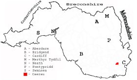
This diagram shows the position of this parish within the county of Glamorgan - click on this to see a full size diagram of the county
|
Parish map (Kain/Oliver)
You can see maps centred on OS grid reference ST135753 (Lat/Lon: 51.470048, -3.24646), Caerau (with Ely) which are provided by:
- OpenStreetMap
- Google Maps
- StreetMap (Current Ordnance Survey maps)
- OpenStreetMap Cymru (Welsh counties only)
- Bing (was Multimap)
- Old Maps Online
- National Library of Scotland (Old Ordnance Survey maps)
- Vision of Britain (Click "Historical units & statistics" for administrative areas.)
- Magic (Geographic information) (Click + on map if it doesn't show)
- GeoHack (Links to on-line maps and location specific services.)
- All places within the same township/parish shown on an Openstreetmap map.
- Nearby townships/parishes shown on an Openstreetmap map.
- Nearby places shown on an Openstreetmap map.
Places, villages, farms etc within Caerau parish as shown on the online parish map from the CD of Historic Parishes of England and Wales: an Electronic Map of Boundaries before 1850 with a Gazetteer and Metadata [computer file]. (Kain, R.J.P., Oliver, R.R.). (Extracted by Gareth Hicks)
- Caerau (148); Caerau (village); Camp; Cyntwell; Highmead; Hosptl.; Lodge; Woodlands
Various items - on the People's Collection Wales site
- West End Brickworks, Caerau
- Church House Farm, Caerau. Photo of the Thurston brothers who lived at Church House Farm in the 19th Century
The Population of Caerau was as follows, and a more detailed breakdown is available.
| 1841 - 80 | 1851 - 87 | 1861 - 131 | 1871 - 102 | 1881 - 112 | 1891 - 187 |
Details of extant records on Archives Network Wales for the following;
- Caerau Civil Parish records 1809-[1980
Ely Hospital, various items - on the People's Collection Wales site