Hide
--- TEST SYSTEM --- TEST SYSTEM --- TEST SYSTEM ---
Hide
Ordnance Survey Maps
hide
Hide
- Historical and Online
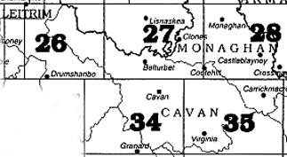
- Map numbers are indicated in the The Alphabetical index to the townlands and towns of Ireland (search title at the Internet Archives)
- OSi - Ordnance Survey Ireland
- Historic 6" First Edition Colour (1829-41)
- Historic 6" Last Edition B&W (1897-1913)
- Town Maps at UCD - University College Dublin - Digital Library
- Griffith's Valuation Maps
- These are ordnance survey maps on which valuation lot numbers are superimposed. They are used to pin point the location of an ancestor found in Griffith's Valuation. Available as a layer at Ask about Ireland
- Contemporary
- Current maps are known as the Discovery Series. They are available from a number of online vendors including the IGSI Bookstore. The map numbers for County Cavan are in the map shown below.