
Hide
--- TEST SYSTEM --- TEST SYSTEM --- TEST SYSTEM ---
Hide
East Leake
hide
Hide
hide
Hide
hide


Hide
Hide
"Leake (East), 10 miles south by west of Nottingham, is a large and well built village, on the south bank of a small rivulet, that flows westward through the Wolds to the Soar, near Kingston. Its parish contains 2,530 acres of land, and 1,149 inhabitants, many of whom are framework knitters. At the enclosure in 1798, 466 acres were allotted in lieu of tithes. The rest belongs to several proprietors, of whom Messrs Burrows, T.D. Hall Esq., Mrs Anthony, Wm. Woodroffe, the Rev. S.V. Dashwood, and the heirs of Lord Rancliffe, are the principal owners. The latter is also lord of the manor. The church, dedicated to St Mary, is a venerable looking edifice, with a low tower, surmounted by a fine lofty spire. The rectory is united with West Leake, and valued in the King's books at £25 4s 7d, now £719. The Rev. John Bateman is the incumbent, and patron of the living, he having purchased the right of patronage from the Marquis of Hastings in 1830. The chancel has been repaired, and the church repewed. The Baptists have a large, handsome chapel, erected in 1763, and enlarged in 1839. The Wesleyan chapel was built in 1798, and enlarged in 1827. A small infant school was erected in 1850 at a cost of £200. A hiring for servants is held on Candlemas Day, and the first and last Fridays in November."
[White's "Directory of Nottinghamshire," 1853]
Hide
The Library at Nottingham will prove useful in your research.
- The parish was in the Leake sub-district of the Loughborough Registration District.
- In the "Surveyors Accounts for Highways and Roads," from 1770-1798 there is included a list of the names of all the village men between the ages of 18 to 80 showing the rental value of their property, if they employed any labourers and if they had any ploughing teams. They could be called on at any time to keep the local roads repaired. It was possible to pay someone else to do your turn, if you could.
- The table below gives census piece numbers, where known:
| Census Year | Piece No. |
|---|---|
| 1861 | R.G. 9 / 2278 |
| 1871 | R.G. 10 / 3259 |
| 1881 | R.G. 11 / 3149 |
| 1891 | R.G. 12 / 2518 |
- The Anglican parish church was dedicated to Saint Mary (the Virgin) in 1350.
- In its early Norman period, the church may have been dedicated to "Saint Leonard of Lek".
- The date of construction is unreported, but appears to be 11th century.
- The church was restored in 1886.
- The church seats 300.
- Chris J. DIXON has a photograph of St. Mary's Church on Geo-graph, taken in April, 2005.
- The Anglican parish register dates from 1600 and is in good condition.
- The church was in the rural deanery of West Bingham.
- The General Baptist chapel was founded here in 1700 and rebuilt in 1839.
- Alan MURRAY-RUST has a photograph of the Baptist Church on Geo-graph, taken in May, 2014. This building is Grade II listed with English Heritage.
- The Wesleyan Methodist chapel was built here in 1862.
- The Cahtolic church is dedicated to Our Lady of the Angels. The present structure dates from 1954.
- J. THOMAS has a photograph of the Catholic Church on Geo-graph, taken in June, 2014.
- Civil Registration began in July, 1837.
- The parish was in the Leake sub-district of the Loughborough Registration District.
- In 1935, the parish was reassigned to the Basford sub-district of the Loughborough Registration District.
This parish and village are in south-west Nottinghamshire and lie about 120 miles north of London, 5 miles north of Loughborough (in Leicestershire) and 9 miles due south of Nottingham. The parish covers 2,540 acres.
The village sits along a small stream that flows into the Soar River. If you are planning a visit:
- By automobile, take the A60 arterial road north out of Loughborough toward Nottingham. At Costock, turn left (west) for East Leake.
- Richard VINCE has a photograph of the a href="http://www.geograph.org.uk/photo/4264712">"Rushcliffe Halt" train station on Geo-graph, taken in November, 2014. This facility is just north of East Leake. The web page author does not know of any passenger rail service to this facility. The last passenger service was in March, 1963. There have been proposals to build a walkway or an elevated station and to re-open the line in the future.
- M. J. RICHARDSON has an aerial photograph of the southern edge of East Leake on Geo-graph, taken in April, 2016..
- We have an extract from White's 1853 Directory relating to this parish.
- Ask for a calculation of the distance from East Leake to another place.
- See our Maps page for additional resources.
You can see maps centred on OS grid reference SK552262 (Lat/Lon: 52.830505, -1.182138), East Leake which are provided by:
- OpenStreetMap
- Google Maps
- StreetMap (Current Ordnance Survey maps)
- Bing (was Multimap)
- Old Maps Online
- National Library of Scotland (Old Ordnance Survey maps)
- Vision of Britain (Click "Historical units & statistics" for administrative areas.)
- English Jurisdictions in 1851 (Unfortunately the LDS have removed the facility to enable us to specify a starting location, you will need to search yourself on their map.)
- Magic (Geographic information) (Click + on map if it doesn't show)
- GeoHack (Links to on-line maps and location specific services.)
- All places within the same township/parish shown on an Openstreetmap map.
- Nearby townships/parishes shown on an Openstreetmap map.
- Nearby places shown on an Openstreetmap map.
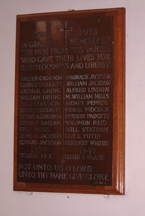
Jonathan BILLINGER has a photograph of the War Memorial across from the church, on Geo-graph, taken in June, 2008.
Andrew JAMIESON has another view of the War Memorial on Geo-graph, taken in April, 2009.
The War Memorial is located on Brookside Road opposite St Mary's Church East Leake. The memorial and ROH (grounds of East Leake Baptist Church) were both unveiled and dedicated on Whit Monday, 24 May 1920. Major George Coke ROBINSON of Widmerpool Hall unveiled the memorial and ROH and the rector of St Mary's and the ministers of the Baptist and Methodist churches officiated.
There is a plaque inside the church listing those who fell in WWI. See the Southwell Church History page.
There are four Commonwealth War Graves in St. Mary's Churchyard:
World War I:
- Arthur DRING, pte., 10th Btn. Northumberland Fusiliers, age 21, died 14 Mar. 1916. Son of Fredrick and Eliza Ann DRING.
- Thomas Aubrey GOODMAN, pte., 8th Btn. North Staff. Regt., age 26, died 10 July 1918. Son of William Powell GOODMAN and Myra Jane GOODMAN.
- Guy Luntley TUTIN, lieut., 3rd Btn. Sherwood Foresters, age 24, died 27 Jan 1919. Son of George and Elizabeth TUTIN.
World War II:
- Leslie James TRAVIS, sergt., 1 Sqdn. RAF Volun. Rsrv., age 28, died 22 Nov. 1941. Son of James TRAVIS, and of Nellie TRAVIS.
The names on the War Memorial Cross are:
- Walter Crowson, lcpl 1st Bn Sherwood Foresters
- George William Doughty, gunner Royal Garrison Artillery
- Arthur Dring, pte. 10th Bn Northumberland Fusiliers
- Joseph William Dring, pte. 19th Bn Lancashire Fusiliers
- Frederick Goodacre, lcpl 2nd Bn Leicestershire Regt.
- Samuel Edward Goodacre, pte. 3rd Bn Grenadier Guards
- Thomas Aubrey Goodman, pte. North Staffordshire Regt.
- Arthur Hallam, pte. 2nd Bn Lancashire Fusiliers
- Fred Hogg, pte. 1st Bn Leicestershire Regt.
- Edward Henry Jackson, pte. 15th Bn Sherwood Foresters
- Lewis Henry Jackson, pte. 1st Bn Sherwood Foresters
- Shadrach Jackson, sapper 297th Railway Coy Royal Engineers
- William Jackson, corp. 1st Bn Leicestershire Regt.
- Alfred Lindon, corp. 20th Bn London Regt.
- Mark William Mills, pte. 15th Bn Sherwood Foresters
- Herbert William Padgett, pte. 8th Bn Leicestershire Regt.
- Sidney Oliver Pepper, pte. 2/5th Bn Leicestershire Regt.
- Frank Wright Pidcock, pte. 2/5th Bn Sherwood Foresters
- Solomon Reid, lcpl. 2nd Bn Grenadier Guards
- Thomas Stanley Roadley, Flight Commander, 4th Bn South Staffs Regt.
- William Statham, able seaman, Royal Navy Division
- Guy Luntley Tutin, Lt. 3rd Bn Sherwood Foresters
- Herbert Arthur Whitby, able seaman, Hood Bn Royal Naval Division
- This place was an ancient parish in Nottinghamshire and it became a Civil Parish when those were established.
- The parish was in the southern division of the ancient Rushcliffe Wapentake in the southern division of the county.
- You may contact the local East Leake Parish Council regarding civic or politcal issues, but they are NOT staffed to help with family history lookups.
- District governance is provided by the Rushcliffe Borough Council.
- Bastardy cases would be heard in the Nottingham petty session hearings.
- In 1798 the Common Land was enclosed here.
- As a result of the 1834 Poor Law Amendment Act, this parish became part of the Loughborough Poor Law Union in Leicestershire.
Year Inhabitants 1801 608 1821 783 1851 1,148 1871 1,031 1881 943 1891 819 1901 876 1911 973 1921 1,023 1931 1,162 1951 2,117