
Hide
--- TEST SYSTEM --- TEST SYSTEM --- TEST SYSTEM ---
Hide
Moreton Pinkney
hide
Hide
hide


Hide
Hide
hide
Hide
"MORTON-PINKNEY, a parish in the hundred of Greens-Norton, county Northampton, 10 miles N. of Brackley, and 8 W. of Towcester. Banbury is its post town. The parish, which is of large extent, is chiefly agricultural. There is a mineral spring in the neighbourhood. The manufacture of lace is carried on extensively. The soil is chiefly clay on a substratum of iron and sandstone. The tithes were commuted for land and a money payment under an Enclosure Act in 1761. The living is a perpetual curacy in the diocese of Peterborough, value £167, in the patronage of Oriel College, Oxford. The church, dedicated to St. Mary, is a stone structure with a low embattled tower containing a clock and five bells. The church was restored and the chancel rebuilt in 1845. The parochial charities produce about £22 10s. per annum. There is a National school supported by subscription. The Baptists have a place of worship. Edward Candler, Esq., is lord of the manor." [From The National Gazetteer of Great Britain and Ireland (1868). Transcribed by Colin Hinson ©2003]
Hide
| Moreton Pinkney, Church of England |
- Ask for a calculation of the distance from Moreton Pinkney to another place.
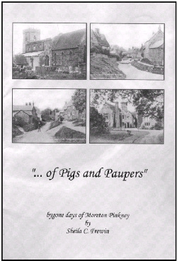
"... of Pigs and Paupers", a fascinating new insight into the history of the village and its inhabitants from 1086 to the early part of the twentieth century has been written by Sheila C Frewin, author of "Bygone Days of Newbold-on-Avon". The contents of the book include Hearth Tax, Militia Lists, Census, Poor Law Records, Charity records, etc.
|
The launch of this publication was held at Moreton Pinkney Village Hall on Saturday 13th August 2005. The book has 157 pages and over 90 photographs, and costs £14.99, with free postage and packing in the U.K. Copies may be ordered from Sheila Titcombe, 17 Lowther Street, Stoke, Coventry, CV2 4GP Cheques should be made payable to "S. C. Titcombe" E-mail: sheila.titcombe@gmail.com |
You can see maps centred on OS grid reference SP569487 (Lat/Lon: 52.133695, -1.170258), Moreton Pinkney which are provided by:
- OpenStreetMap
- Google Maps
- StreetMap (Current Ordnance Survey maps)
- Bing (was Multimap)
- Old Maps Online
- National Library of Scotland (Old Ordnance Survey maps)
- Vision of Britain (Click "Historical units & statistics" for administrative areas.)
- English Jurisdictions in 1851 (Unfortunately the LDS have removed the facility to enable us to specify a starting location, you will need to search yourself on their map.)
- Magic (Geographic information) (Click + on map if it doesn't show)
- GeoHack (Links to on-line maps and location specific services.)
- All places within the same township/parish shown on an Openstreetmap map.
- Nearby townships/parishes shown on an Openstreetmap map.
- Nearby places shown on an Openstreetmap map.