
Hide
--- TEST SYSTEM --- TEST SYSTEM --- TEST SYSTEM ---
Hide
Maidwell
hide
Hide
hide


Hide
Hide
"MAIDWELL, a parish in the hundred of Rothwell, county Northampton, 10½ miles N. of Northampton, its post town, and 7 S. of Market Harborough. The village, which is small, is situated on the high road from Northampton to Market Harborough, and is chiefly agricultural. There are some mineral springs in the neighbourhood. The parish includes the hamlet of Maidwell St. Peter's, formerly a distinct parish Limestone is quarried for building purposes, and for burning into lime. The tithes were commuted under an Enclosure Act in 1696 for land and a money payment. The living is a rectory in the diocese of Peterborough, value £218. The church, dedicated to St. Mary, has a tower containing a clock and five bells. It is very neatly arranged, and is in good repair. The church of St. Peter, having become dilapidated, was taken down in 1543. The parochial charities produce about £21 per annum, including the endowment of a scholarship at Clare Hall, Cambridge, founded by Lady Trott, for a youth of this parish. There is a free school for both sexes. Henry H. H. Hungerford, Esq., of Dingley, is lord of the manor and the principal landowner."[From The National Gazetteer of Great Britain and Ireland (1868). Transcribed by Colin Hinson ©2003]
Hide
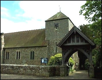
| Maidwell, Church of England |
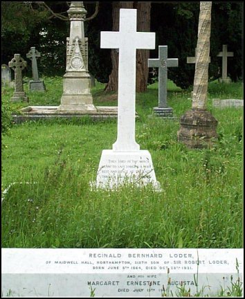
Penuel Ellis-Brown discovered graves of members of the Loder family, of Maidwell Hall, whilst researching in the graveyard of St Mary's Church, Slaugham, West Sussex, and has kindly supplied the following photographs.
St Mary's Church, Slaugham, West Sussex
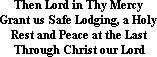
The inscription at the foot of the cross reads :
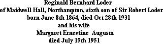
The edging at the foot of the grave is inscribed :
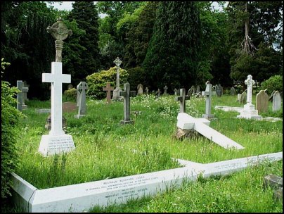
The grave to the right, with the fallen cross, bears three inscriptions at the foot of the grave :

The National Gazetteer of Great Britain and Ireland - 1868
"MAIDWELL, a parish in the hundred of Rothwell, county Northampton, 10½ miles N. of Northampton, its post town, and 7 S. of Market Harborough. The village, which is small, is situated on the high road from Northampton to Market Harborough, and is chiefly agricultural. There are some mineral springs in the neighbourhood. The parish includes the hamlet of Maidwell St. Peter's, formerly a distinct parish Limestone is quarried for building purposes, and for burning into lime. The tithes were commuted under an Enclosure Act in 1696 for land and a money payment. The living is a rectory* in the diocese of Peterborough, value £218. The church, dedicated to St. Mary, has a tower containing a clock and five bells. It is very neatly arranged, and is in good repair. The church of St. Peter, having become dilapidated, was taken down in 1543. The parochial charities produce about £21 per annum, including the endowment of a scholarship at Clare Hall, Cambridge, founded by Lady Trott, for a youth of this parish. There is a free school for both sexes. Henry H. H. Hungerford, Esq., of Dingley, is lord of the manor and the principal landowner."
- Ask for a calculation of the distance from Maidwell to another place.
You can see maps centred on OS grid reference SP741769 (Lat/Lon: 52.385549, -0.912251), Maidwell which are provided by:
- OpenStreetMap
- Google Maps
- StreetMap (Current Ordnance Survey maps)
- Bing (was Multimap)
- Old Maps Online
- National Library of Scotland (Old Ordnance Survey maps)
- Vision of Britain (Click "Historical units & statistics" for administrative areas.)
- English Jurisdictions in 1851 (Unfortunately the LDS have removed the facility to enable us to specify a starting location, you will need to search yourself on their map.)
- Magic (Geographic information) (Click + on map if it doesn't show)
- GeoHack (Links to on-line maps and location specific services.)
- All places within the same township/parish shown on an Openstreetmap map.
- Nearby townships/parishes shown on an Openstreetmap map.
- Nearby places shown on an Openstreetmap map.