
Hide
--- TEST SYSTEM --- TEST SYSTEM --- TEST SYSTEM ---
Hide
Hillington
hide
Hide
hide
Hide
hide
Hide
Hide
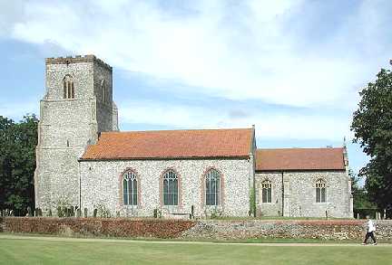
"HILLINGTON is a well-built village, pleasantly situated on the Fakenham turnpike, 8 miles N.E. by E. of Lynn, and has in its parish 321 souls, and 2,437 acres of land, nearly all belonging to Sir Wm. John Henry Browne Ffolkes, Bart., the lord of the manor, who resides at HILLINGTON HALL, a handsome mansion, seated in a spacious and well-wooded lawn and park, on the north side of the village, commanding a fine prospect of the vale. . . . The CHURCH, (St. Mary,) except the tower and chancel, was rebuilt in 1824, at the cost of £800. It contains several tombs and effigies of the Hovell family, whose estates passed to the Brownes and the Ffolkes. Here is also a handsome monument in memory of the late Sir Martin Browne Ffolkes, who was created a baronet in 1774. The rectory, valued in the King's Book at £13 6s. 8d., and in 1831 at £426, is in the patronage of Sir W.J.H.B. Ffolkes, Bart., and incumbency of the Rev. Robt. Hales, M.A., who has about 60A. of glebe." [William White, History, Gazetteer, and Directory of Norfolk (1845) - Transcription copyright © Pat Newby]
Hide
See also Hellington.
Hide
- 1891: Surname List (this is a link to an archived copy)
See also Norfolk Parish Links: Censuses
- In 1883 the parish was in the Deanery of Lynn Norfolk, in the archdeaconry of Norwich.
- The parish church is dedicated to St Mary the Virgin.
- Church of St Mary
- Description and pictures.
- Church of St Mary
- Services, etc.
- Church of St Mary
- Picture of the church.
- Parish Register Transcripts
- Baptisms 1813-1880
- Marriages 1695-1837
- See Phillimore's Marriage Registers, Volume 9.
- Marriages
- These are included in Boyd's Marriage Index.
- Church Inventory
- Bells, books, communion plate, etc, in 1783.
See also Norfolk Parish Links: Church Records
For the civil registration of births, marriages and deaths between 1837 and 1930 (and for the censuses from 1851 to 1901), Hillington was in Freebridge Lynn Registration District.
- Hillington Water Mill
- Pictures.
- Ask for a calculation of the distance from Hillington to another place.
Hillington is in Freebridge Lynn hundred.
You can see maps centred on OS grid reference TF723253 (Lat/Lon: 52.797416, 0.55369), Hillington which are provided by:
- OpenStreetMap
- Google Maps
- StreetMap (Current Ordnance Survey maps)
- Bing (was Multimap)
- Old Maps Online
- National Library of Scotland (Old Ordnance Survey maps)
- Vision of Britain (Click "Historical units & statistics" for administrative areas.)
- English Jurisdictions in 1851 (Unfortunately the LDS have removed the facility to enable us to specify a starting location, you will need to search yourself on their map.)
- Magic (Geographic information) (Click + on map if it doesn't show)
- GeoHack (Links to on-line maps and location specific services.)
- All places within the same township/parish shown on an Openstreetmap map.
- Nearby townships/parishes shown on an Openstreetmap map.
- Nearby places shown on an Openstreetmap map.
- Roll of Honour
- World War 1.
- After 1834 Hillington became part of the Freebridge Lynn Union, and the workhouse was at Gayton.
These figures are from the population tables which were produced after the 10-yearly national censuses. The "Families" heading includes families and single occupiers.
|
|
There may be more people living in detached parts of the parish (if there were any) and, if so, the number may or may not be included in the figures above. It is quite difficult to be sure from the population tables.