
Hide
--- TEST SYSTEM --- TEST SYSTEM --- TEST SYSTEM ---
Hide
Grimston
hide
Hide
hide
Hide
hide


Hide
Hide
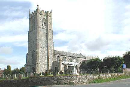
"GRIMSTON is an extensive parish of scattered houses, 1¾ miles from the Grimston Road station on the Eastern and Midlands railway, 106 from London and 7 east from Lynn, in the Western division of the county, Freebridge Lynn hundred and union, Lynn county court district, rural deanery of Lynn and archdeaconry and diocese of Norwich. The church of St. Bartholomew is a spacious edifice in the Early English style, has a chancel, nave, aisles, transepts, a loft square embattled tower containing 6 bells and a porch: it contains a good stained window, representing Paul before Felix. The register dates from the year 1552. The living is a rectory, yearly value £400, in the gift of the President of Queen's College, Cambridge, and held by the Rev. John Fowler M.A. of that college.“ [Kelly's Directory for Cambridgeshire, Norfolk & Suffolk (1883) - Transcription copyright © E.C. “Paddy” Apling]
Hide
The name may also be spelled Grimstone.
It includes the hamlet of Pott Row.
See also Griston.
Hide
- 1891: Surname List (this is a link to an archived copy)
See also Norfolk Parish Links: Censuses
- In 1883 the parish was in the Deanery of Lynn Norfolk, in the archdeaconry of Norwich.
- The parish church is dedicated to St Botolph.
- Church of St Botolph
- Description, minister, services, pictures, etc.
- Church of St Botolph
- Picture of the church.
- Goodall, Armitage
- History of St Botolph's Church, Grimston.
[1923]
- Marriages 1552-1837
- See Phillimore's Marriage Registers, Volume 9.
- Marriages
- These are included in Boyd's Marriage Index.
See also Norfolk Parish Links: Church Records
For the civil registration of births, marriages and deaths between 1837 and 1930 (and for the censuses from 1851 to 1901), Grimston was in Freebridge Lynn Registration District.
- Grimston
- Parish council, newsletters, news, events, pictures, etc.
- 1883: Kelly's Directory for Cambridgeshire, Norfolk & Suffolk (this is a link to an archived copy)
See also Norfolk Parish Links: Directories
- Ask for a calculation of the distance from Grimston to another place.
Grimston is in Freebridge Lynn hundred.
- Parish outline and location.
- See Parish Map for Freebridge Lynn Registration District, 1836 (this is a link an archived copy) and nearby places.
See also Norfolk Parish Links: Maps
You can see maps centred on OS grid reference TF719225 (Lat/Lon: 52.773174, 0.546311), Grimston which are provided by:
- OpenStreetMap
- Google Maps
- StreetMap (Current Ordnance Survey maps)
- Bing (was Multimap)
- Old Maps Online
- National Library of Scotland (Old Ordnance Survey maps)
- Vision of Britain (Click "Historical units & statistics" for administrative areas.)
- English Jurisdictions in 1851 (Unfortunately the LDS have removed the facility to enable us to specify a starting location, you will need to search yourself on their map.)
- Magic (Geographic information) (Click + on map if it doesn't show)
- GeoHack (Links to on-line maps and location specific services.)
- All places within the same township/parish shown on an Openstreetmap map.
- Nearby townships/parishes shown on an Openstreetmap map.
- Nearby places shown on an Openstreetmap map.
- After 1834 Grimston became part of the Freebridge Lynn Union, and the workhouse was at Gayton.
- Grimston Church Hill School (this is a link to an archived copy)
- Picture of the school.
- Charity Commission for England and Wales
- Scheme dated 17th March, 1888, for the administration of the Grimston School Trust, Norfolk.
[London, Printed by Shaw and Sons, 1888]