
Hide
--- TEST SYSTEM --- TEST SYSTEM --- TEST SYSTEM ---
Hide
Whinburgh
hide
Hide
hide
Hide
hide


Hide
Hide
"WHINBURGH, or Whinbergh, is a scattered hamlet and parish, on the Hingham road, 3½ miles S.S.E. of East Dereham, containing 209 inhabitants, and 1242 acres of land. Sir W.R. Clayton, Bart., owns most of the soil, and is lord of this and several other manors, for which Mr. E.R. Grigson, of Watton, is steward. The fines in Whinburgh are certain. The Church (St. Mary) is a rectory, valued in the King's Book at £6. 18s. 6d., and now enjoyed, with that of Westfield, by the Rev. Wm. Grigson, who purchased the patronage of both livings of Sir W.R. Clayton. The united rectories were valued in 1831 at £302. About 500 acres, called Whinburgh Park, pays only a yearly modus of 20s., and the tithes of the rest of the parish were commuted in 1839, for £169. 7s. per annum. On the land called Manor yards, the foundations of a large mansion and a double moat are still visible. In the 15th of Edward I., Lord Bardolph claimed here view of frankpledge, a weekly market, and an annual fair." [William White, History, Gazetteer, and Directory of Norfolk (1845) - Transcription copyright © Peter Apling]
Hide
Whinburgh may also be spelled Whinborough.
Hide
- Mid-Norfolk Family History Society
- The Memorial Inscriptions of the Church and Churchyard of St Mary the Virgin, Whinburgh, Norfolk.
[Mid-Norfolk Family History Society, 2003]
See also Norfolk Parish Links: Cemeteries
- 1891: Surname List (this is a link to an archived copy)
See also Norfolk Parish Links: Censuses
| Chapel, Whinburgh, Primitive Methodist |
- In 1883 the parish was in the Deanery of Hingham, in the archdeaconry of Norfolk.
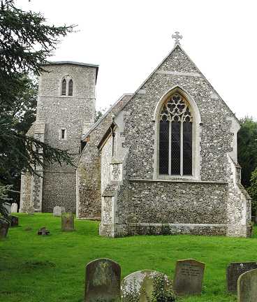
- The parish church is dedicated to St Mary the Virgin.
- Church of St Mary
- Description and pictures.
- Church of St Mary
- Services, minister, location, picture, etc
- Church of St Mary
- Picture of the church.
- Taylor, Ron
- The Church of St Mary the Virgin, Whinburgh.
[Whinburgh with Westfield P.C.C., 1990]
- Archdeacon's Transcripts or Bishop's Transcripts
- Baptisms, Marriages and Burials.
- Marriages
- These are not included in Boyd's Marriage Index or Phillimore's Marriage Registers.
See also Norfolk Parish Links: Church Records
For the civil registration of births, marriages and deaths between 1837 and 1930 (and for the censuses from 1851 to 1901), Whinburgh was in Mitford and Launditch Registration District.
- Taylor, Ron
- Eighty Years of Whinburgh: A collection of news items about the village from the columns of the Dereham and Fakenham Times between the years 1880 and 1959.
[1992]
- 1845: White's History, Gazetteer, and Directory of Norfolk
- 1854: White's History, Gazetteer, and Directory of Norfolk (this is a link to an archived copy)
- 1883: White's History, Gazetteer, and Directory of Norfolk
- 1883: Kelly's Directory for Cambridgeshire, Norfolk & Suffolk (this is a link to an archived copy)
See also Norfolk Parish Links: Directories
- Ask for a calculation of the distance from Whinburgh to another place.
Whinburgh is in Mitford hundred.
- Inclosure
- See Westfield
- Parish outline and location.
- See Parish Map for Mitford and Launditch Registration District, 1836 (this is a link an archived copy) and nearby places.
See also Norfolk Parish Links: Maps
You can see maps centred on OS grid reference TG006092 (Lat/Lon: 52.643063, 0.963791), Whinburgh which are provided by:
- OpenStreetMap
- Google Maps
- StreetMap (Current Ordnance Survey maps)
- Bing (was Multimap)
- Old Maps Online
- National Library of Scotland (Old Ordnance Survey maps)
- Vision of Britain (Click "Historical units & statistics" for administrative areas.)
- English Jurisdictions in 1851 (Unfortunately the LDS have removed the facility to enable us to specify a starting location, you will need to search yourself on their map.)
- Magic (Geographic information) (Click + on map if it doesn't show)
- GeoHack (Links to on-line maps and location specific services.)
- All places within the same township/parish shown on an Openstreetmap map.
- Nearby townships/parishes shown on an Openstreetmap map.
- Nearby places shown on an Openstreetmap map.
- Roll of Honour
- World War 1.
- After 1834 Whinburgh became part of the Mitford and Launditch Union, and the workhouse was at Gressenhall.
These figures are from the population tables which were produced after the 10-yearly national censuses. The "Families" heading includes families and single occupiers.
|
|
There may be more people living in detached parts of the parish (if there were any) and, if so, the number may or may not be included in the figures above. It is quite difficult to be sure from the population tables.