
Hide
--- TEST SYSTEM --- TEST SYSTEM --- TEST SYSTEM ---
Hide
Scarning
hide
Hide
hide
Hide
hide


Hide
Hide
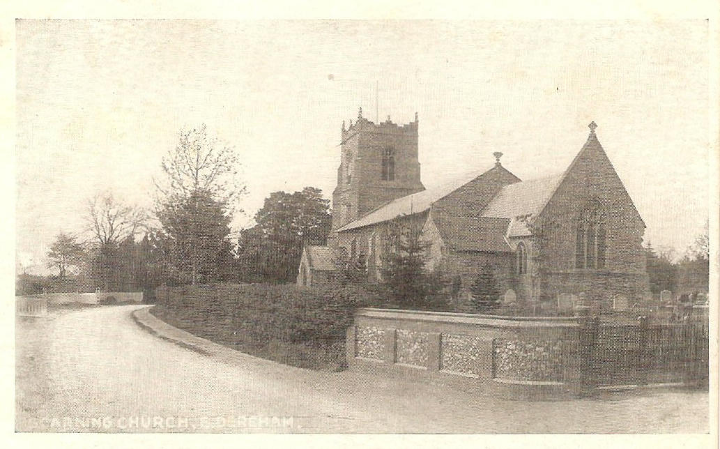
"SCARNING is a fertile parish, extending from 1 to 3½ miles westward from East Dereham, on the Swaffham road, and having many scattered houses, 613 inhabitants, and 3,870 acres of land, partly belonging to Edwd Lombe, Esq., the lord of the manor, which is subject to arbitrary fines, and has a court baron yearly. . . . The CHURCH, dedicated to St. Peter and St. Paul, has a massive tower, . . . The living, valued in the King's Book at £9. 0s. 2d., and in 1831, at £401, is both rectorial and vicarial; the Rev. Philip Du Val Aufrere, the incumbent, having half of the rectorial tithes, and the patron, Edward Lombe, Esq., being impropriator of the other moiety. The Free School was founded by Wm. Secker, who endowed it in 1604,." [William White History, Gazetteer, and Directory of Norfolk (1845) - Transcription copyright © Pat Newby]
Hide
- 1891: Surname List (this is a link to an archived copy)
- 1901
See also Norfolk Parish Links: Censuses
| Chapel, Scarning, Congregational |
- In 1883 the parish was in the Deanery of Brisley, in the archdeaconry of Norwich.
It could have been in a different deanery or archdeaconry both before and after this date. - The parish church is dedicated to St Peter and St Paul.
- Church of St Peter and St Paul
- Description and pictures.
- Church of St Peter and St Paul
- Services, etc.
- Church of St Peter and St Paul
- Picture of the church.
- Marriages
- These are not included in Boyd's Marriage Index or Phillimore's Marriage Registers.
See also Norfolk Parish Links: Church Records
For the civil registration of births, marriages and deaths between 1837 and 1930 (and for the censuses from 1851 to 1901), Scarning was in Mitford and Launditch Registration District.
- 1845: White's History, Gazetteer, and Directory of Norfolk
- 1850: Hunt's Directory of East Norfolk with Part of Suffolk
- 1854: White's History, Gazetteer, and Directory of Norfolk (this is a link to an archived copy)
- 1883: Kelly's Directory for Cambridgeshire, Norfolk and Suffolk (this is a link to an archived copy)
See also Norfolk Parish Links: Directories
- Ask for a calculation of the distance from Scarning to another place.
Scarning is in Launditch Hundred.
- Parish outline and location.
- See Parish Map for Launditch Hundred
- Description of Launditch Hundred
- 1845: White's History, Gazetteer, and Directory of Norfolk
- Great Britain: Statute
- Scarning Inclosure Act, 1765.
An act for dividing and inclosing the common called Scarning Common, and the greens called Pound Green, Pope's Green and Bett's Green, lying within the several manors of Scarning Hall, Drayton Hall, and Northern Hall, Scarning Parvo, Guntons and Rougholme, on the part of Hoe, of some or one of them, and in the parish of Scarning, in the county of Norfolk.
[1765] - Great Britain. Inclosure Commissioners
- Statement of claims (90): Scarning, Hoe, Worthing and Dillington.
Drawn up in pursuance of the Act of Inclosure, 1811.
[1811] - Great Britain: Statute
- Scarning and other parishes Inclosure Act, 1811.
An act for inclosing lands in the parishes of Scarning, Hoe, Worthing, and Dillington, in the county of Norfolk: 6 May 1811.
[London, George Eyre and Andrew Strahan, 1811]
You can see maps centred on OS grid reference TF955121 (Lat/Lon: 52.671438, 0.889634), Scarning which are provided by:
- OpenStreetMap
- Google Maps
- StreetMap (Current Ordnance Survey maps)
- Bing (was Multimap)
- Old Maps Online
- National Library of Scotland (Old Ordnance Survey maps)
- Vision of Britain (Click "Historical units & statistics" for administrative areas.)
- English Jurisdictions in 1851 (Unfortunately the LDS have removed the facility to enable us to specify a starting location, you will need to search yourself on their map.)
- Magic (Geographic information) (Click + on map if it doesn't show)
- GeoHack (Links to on-line maps and location specific services.)
- All places within the same township/parish shown on an Openstreetmap map.
- Nearby townships/parishes shown on an Openstreetmap map.
- Nearby places shown on an Openstreetmap map.
- Roll of Honour
- World Wars 1 and 2.
- After 1834 Scarning became part of the Mitford and Launditch Union, and the workhouse was at Gressenhall.
These figures are from the population tables which were produced after the 10-yearly national censuses. The "Families" heading includes families and single occupiers.
|
|
There may be more people living in detached parts of the parish (if there were any) and, if so, the number may or may not be included in the figures above. It is quite difficult to be sure from the population tables.
- 1861 Census
- "The increase of population in Scarning is attributed to the proximity of the parish to the town of East Dereham."
- 1901 Census
- "Including Daffy Green, Podmore, and part of Hulver Street."
Other population figures
- Lloyd Pritchard, Muriel Florence
- The Misappropriation of Scarning School.
[London, Oxford University Press, in "Notes and Queries", vol.195, 1950]