
Hide
--- TEST SYSTEM --- TEST SYSTEM --- TEST SYSTEM ---
Hide
Saxthorpe
hide
Hide
hide
Hide
hide


Hide
Hide
"SAXTHORPE, 5 miles N.W. of Aylsham, on the north side of the Bure, has 342 souls, and 2073 acres of land, of which 870A., with the manorial rights, were purchased about 25 years ago, by the Earl of Orford, of the Elvin family. The rest of the soil belongs to other proprietors. Pembroke College, Cambridge, has the appropriation of the rectory, and the patronage of the vicarage, valued in the King's Book at £4. 13s. 4d., and in 1831, at £144. It is enjoyed by the Rev. Samuel Ashby, M.A., and was augmented with £400 by W. Trolope, and Queen Anne's Bounty, in 1739. . . . The Church (St. Andrew,) was built about 1490; previous to which, here was St. Dunstan's Chapel, founded by Amer de Valence, in 1313, on the site still called Chapel close. In 1666, the Rev. John Vaughan, a late vicar, left £260 to the Boy's Hospital, in Norwich, and directed that half the boys admitted in consideration thereof, should be sent from Saxthorpe." [William White History, Gazetteer, and Directory of Norfolk (1845) - Transcription copyright © Richard Jones]
Hide
- 1851
- 1881
- 1891: Surname List (this is a link to an archived copy)
See also Norfolk Parish Links: Censuses
- In 1883 the parish was in the Deanery of Ingworth, in the archdeaconry of Norwich.
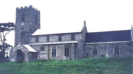
It could have been in a different deanery or archdeaconry both before and after this date. - The parish church is dedicated to St Andrew.
- Church of St Andrew
- Description and pictures.
- Church of St Andrew
- Minister, services, description, picture, etc.
- Church of St Andrew
- Picture of the church.
- Parish Register Transcripts
- Baptisms 1813-1880
- Archdeacons' Transcripts
- Baptisms 1709-1805, Marriages 1709-1802 and Burials 1709-1805.
[Parish Register Transcription Society, Dart Series, 2000?] - Marriages
- These are not included in Boyd's Marriage Index or Phillimore's Marriage Registers.
See also Norfolk Parish Links: Church Records
For the civil registration of births, marriages and deaths between 1837 and 1930 (and for the censuses from 1851 to 1901), Saxthorpe was in Aylsham Registration District.
- Wilson, Janet
- The Heritage of Corpusty and Saxthorpe.
[North Walsham, Rounce and Wortley, 1990] - Wilson, Janet; and Brewster, Anne
- Saxthorpe and Corpusty: twin villages and their churches on the River Bure.
[Norwich, Gallpen Press, 1988]
- 1845: White's History, Gazetteer, and Directory of Norfolk
- 1850: Hunt's Directory of East Norfolk with Part of Suffolk
- 1883: White's History, Gazetteer, and Directory of Norfolk
- 1883: Kelly's Directory for Cambridgeshire, Norfolk and Suffolk (this is a link to an archived copy)
See also Norfolk Parish Links: Directories
- Ask for a calculation of the distance from Saxthorpe to another place.
Saxthorpe is in South Erpingham Hundred.
- Parish outline and location.
- See Parish Map for South Erpingham Hundred
- Description of South Erpingham Hundred
- 1845: White's History, Gazetteer, and Directory of Norfolk
You can see maps centred on OS grid reference TG116305 (Lat/Lon: 52.830047, 1.139315), Saxthorpe which are provided by:
- OpenStreetMap
- Google Maps
- StreetMap (Current Ordnance Survey maps)
- Bing (was Multimap)
- Old Maps Online
- National Library of Scotland (Old Ordnance Survey maps)
- Vision of Britain (Click "Historical units & statistics" for administrative areas.)
- English Jurisdictions in 1851 (Unfortunately the LDS have removed the facility to enable us to specify a starting location, you will need to search yourself on their map.)
- Magic (Geographic information) (Click + on map if it doesn't show)
- GeoHack (Links to on-line maps and location specific services.)
- All places within the same township/parish shown on an Openstreetmap map.
- Nearby townships/parishes shown on an Openstreetmap map.
- Nearby places shown on an Openstreetmap map.
- After 1834 Saxthorpe became part of the Aylsham Union, and the workhouses were at Buxton and Oulton. These were replaced by a new workhouse at Aylsham in 1849.
These figures are from the population tables which were produced after the 10-yearly national censuses. The "Families" heading includes families and single occupiers.
|
|
There may be more people living in detached parts of the parish (if there were any) and, if so, the number may or may not be included in the figures above. It is quite difficult to be sure from the population tables.