
Hide
--- TEST SYSTEM --- TEST SYSTEM --- TEST SYSTEM ---
Hide
Sandringham
hide
Hide
hide
Hide
hide


Hide
Hide
"SANDRINGHAM, a small village and parish, containing only 53 inhabitants, and 1,110 acres of land, 7½ [miles] N.N.E. of Lynn, has its name from its deep sandy soil, of which more than 200A. are on the extensive heath stretching hence to Wolverton. The Hon. Charles Spencer Cowper is the sole proprietor, and resides in Sandringham Hall, a large cemented brick mansion, in a park of 300A., . . . He is also patron of the CHURCH, a small ancient fabric, standing on an eminence, and dedicated to St. Mary Magdalen. The rectory, valued in the King's Book at £5 6s. 8d., is consolidated with Babingley, and is now enjoyed by the Rev. Geo. Browne Moxon, B.A., and valued at £171 per annum, with 25A. of glebe. The other residents are, Wm. Durrant, farmer; and Chas. Kent, parish-clerk. " [William White History, Gazetteer, and Directory of Norfolk (1845) - Transcription copyright © Pat Newby]
Hide
- 1891: Surname List (this is a link to an archived copy)
See also Norfolk Parish Links: Censuses
- In 1883 the parish was in the Deanery of Lynn Norfolk, in the archdeaconry of Norwich.
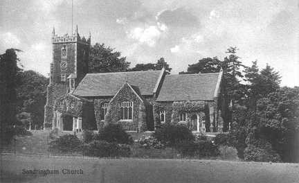
- The parish church is dedicated to St Mary Magdalene.
- Church of St Mary Magdalene
- Description and picture.
- Church of St Mary Magdalene
- Picture of the church.
- Ashton, Patrick
- St Mary Magdalene, Sandringham Church and the gardens of Sandringham House.
[ISBN 0853720657, Pitkin Pride of Britain series, 1992]
- Marriages 1561-1812
- See Phillimore's Marriage Registers, Volume 2.
- Marriages
- These are included in Boyd's Marriage Index.
See also Norfolk Parish Links: Church Records
For the civil registration of births, marriages and deaths between 1837 and 1930 (and for the censuses from 1851 to 1901), Sandringham was in Freebridge Lynn Registration District.
- Dutt, William A.
- The King's Homeland: Sandringham and north-west Norfolk; with an introduction by H. Rider Haggard.
[London, published for the Homeland Association by A. & C. Black, 1904] - Lingwood, Lemmon
- Jarrold's Guide to Hunstanton.
The illustrated handbook to Hunstanton and neighbourhood, including Sandringham, Castle Rising, King's Lynn, Heacham, West Newton, and Snettisham.
[Norwich, Jarrold, 1900s] - Massen, Simon
- Sandringham Past: A fascinating compilation of picture postcards taken in the early 1900s.
[The Author, 1992] - Ralph, Walter (photographer)
- Souvenir of Sandringham: Album of 12 postcards.
[Dersingham, Walter Ralph, 1930s]
- Ask for a calculation of the distance from Sandringham to another place.
Sandringham is in Freebridge Lynn hundred.
- Day, James Wentworth
- Kings Lynn and Sandringham through the ages.
[Ipswich, East Anglian Magazine Ltd, 1977] - Jones, C. Rachel (Mrs Herbert Jones)
- Sandringham: past and present with some historic memorials of the Norfolk coast.
[Jarrold, 1888]
- Sandringham House and Estate
- Description, events, pictures, etc.
- Sandringham House and Estate
- Pictures of the estate.
- Baker, David J.
- The Royal Gunroom at Sandringham.
[ISBN 071488040x, Phaidon Christie's, 1989] - Cathcart, Helen
- Sandringham: The Story of a Royal Home.
[London, W.H. Allen, 1964] - Cresswell, Louisa
- Eighteen years on the Sandringham Estate; by "the Lady Farmer".
[London, Temple Company, 1887] - Hepworth, Philip
- Royal Sandringham.
[ISBN 0903619253, Norwich, Wensum Books Ltd, 1978] - Messent, Claude J.W.
- The Architecture on the Royal Estate of Sandringham: an architectural history with reproductions of pencil sketches.
[ISBN 0950132519, Blofield, 1974] - Norwich Mercury
- Names of the inhabitants of the County of Norfolk who presented the Norwich Gates to His Royal Highness the Prince of Wales, April 7th, 1863.
[Norwich, Norwich Mercury, 1863] - Rush, Len
- Captain of the Queen's Flight.
(Len Rush and the Queen's racing pigeons).
[ISBN 0747500134, London, Bloomsbury, 1987] - Winton, Michael J.
- Sandringham House: A royal home for Edward and Alexandra.
[The Author, 1975]
- Faden's Map of Norfolk
- Extract showing Sandringham.
- Parish outline and location.
- See Parish Map for Freebridge Lynn Registration District, 1836 (this is a link an archived copy)
and nearby places.
See also Norfolk Parish Links: Maps
You can see maps centred on OS grid reference TF695287 (Lat/Lon: 52.82958, 0.515154), Sandringham which are provided by:
- OpenStreetMap
- Google Maps
- StreetMap (Current Ordnance Survey maps)
- Bing (was Multimap)
- Old Maps Online
- National Library of Scotland (Old Ordnance Survey maps)
- Vision of Britain (Click "Historical units & statistics" for administrative areas.)
- English Jurisdictions in 1851 (Unfortunately the LDS have removed the facility to enable us to specify a starting location, you will need to search yourself on their map.)
- Magic (Geographic information) (Click + on map if it doesn't show)
- GeoHack (Links to on-line maps and location specific services.)
- All places within the same township/parish shown on an Openstreetmap map.
- Nearby townships/parishes shown on an Openstreetmap map.
- Nearby places shown on an Openstreetmap map.
- Roll of Honour
- World Wars 1 and 2.
- McCrery, Nigel
- All the King's Men: One of the greatest mysteries of the First World War finally solved.
[ISBN 0671018310, Pocket Books, 1999]
[Originally published as: The Vanished Battalion, Simon & Schuster, 1992] - Williamson, Tom
- The Disappearance of the King's Company in Gallipoli: The day the hills caught fire.
[ISBN 072231261x, Stockwell, 1979]
- After 1834 Sandringham became part of the Freebridge Lynn Union, and the workhouse was at Gayton.