
Hide
--- TEST SYSTEM --- TEST SYSTEM --- TEST SYSTEM ---
Hide
West Newton
hide
Hide
hide
Hide
hide
Hide
Hide
"NEWTON (WEST) is a pleasant village, on an eminence, 7 miles N.N.E. of Lynn. It has a large brewery, and comprises in its parish 242 inhabitants, and 1,221A. 3R. 35P. of land, lying in the two manors of Rivetts and Buckenham, of which the Hon. Chas. Spencer Cowper, is now lord and owner of most of the soil. The common (280A.) was enclosed in 1806, when 12 acres were allotted to the poor for fuel, &c. The CHURCH, (St. Peter and St. Paul,) is a venerable fabric, which was re-pewed in 1805, when the north aisle was taken down, and the arches walled up. The rectory, valued in the King's Book at £5 6s. 8d., and in 1831 at £178, is in the patronage of the Crown, and is now enjoyed by the Rev. John Fairfax Francklin, M.A., who has a good residence, and about 8A. of glebe." [William White, History, Gazetteer, and Directory of Norfolk (1845) - Transcription copyright © Pat Newby]
Hide
See also Newton by Castle Acre, Newton Flotman and Newton St Faith (Horsham St Faith).
Hide
- 1891: Surname List (this is a link to an archived copy)
See also Norfolk Parish Links: Censuses
- In 1883 the parish was in the Deanery of Lynn Norfolk, in the archdeaconry of Norwich.
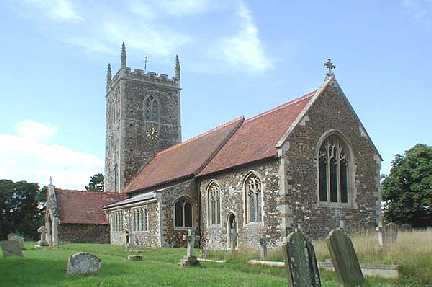
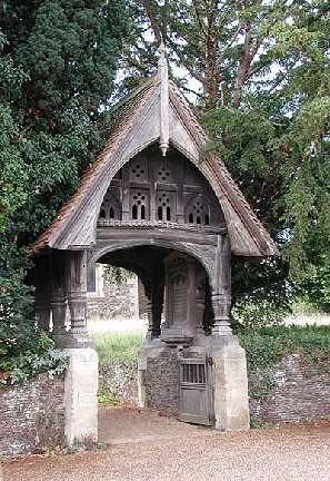
- The parish church is dedicated to St Peter and St Paul.
- Church of St Peter and St Paul
- Description and pictures.
- Church of St Peter and St Paul
- Picture of the church.
- Church of St Peter and St Paul
- Picture of the church.
- West Newton Church Council
- Parish Church of St Peter and St Paul, West Newton.
[West Newton, West Newton Church Council, 1970s]
- Marriages 1561-1837
- See Phillimore's Marriage Registers, Volume 5.
- Marriages
- These are included in Boyd's Marriage Index.
See also Norfolk Parish Links: Church Records
For the civil registration of births, marriages and deaths between 1837 and 1930 (and for the censuses from 1851 to 1901), West Newton was in Freebridge Lynn Registration District.
- West Newton (this is a link to an archived copy)
- Description and pictures.
- West Newton Mill
- Description, history and pictures.
- Lingwood, Lemmon
- Jarrold's Guide to Hunstanton.
The illustrated handbook to Hunstanton and neighbourhood, including Sandringham, Castle Rising, King's Lynn, Heacham, West Newton, and Snettisham.
[Norwich, Jarrold, 1900s] - Durst, David W.
- Norfolk Flax.
[Norwich, Norfolk Industrial Archaeology Society, in: "Journal of the Norfolk Industrial Archaeology Society", vol.2, no.5, 1980] - Searle, Antony G. and Tuck, James W.
- The King's Flax and the Queen's Linen.
H.M. Norfolk Flax Establishment, West Newton, 1930s-1950s.
[ISBN 0948400781, Larks Press, 1999]
- Ask for a calculation of the distance from West Newton to another place.
West Newton is in Freebridge Lynn hundred.
You can see maps centred on OS grid reference TF697276 (Lat/Lon: 52.818792, 0.517128), West Newton which are provided by:
- OpenStreetMap
- Google Maps
- StreetMap (Current Ordnance Survey maps)
- Bing (was Multimap)
- Old Maps Online
- National Library of Scotland (Old Ordnance Survey maps)
- Vision of Britain (Click "Historical units & statistics" for administrative areas.)
- English Jurisdictions in 1851 (Unfortunately the LDS have removed the facility to enable us to specify a starting location, you will need to search yourself on their map.)
- Magic (Geographic information) (Click + on map if it doesn't show)
- GeoHack (Links to on-line maps and location specific services.)
- All places within the same township/parish shown on an Openstreetmap map.
- Nearby townships/parishes shown on an Openstreetmap map.
- Nearby places shown on an Openstreetmap map.
- Roll of Honour
- World War 1.
- After 1834 West Newton became part of the Freebridge Lynn Union, and the workhouse was at Gayton.