
Hide
--- TEST SYSTEM --- TEST SYSTEM --- TEST SYSTEM ---
Hide
Fishley
hide
Hide
hide
Hide
hide


Hide
Hide
"FISHLEY, 7½ miles W.N.W. of Yarmouth, is a decayed parish, united with Upton, for the support of the poor and roads, and containing only nine souls, and 466A. 2R. 10P. of land, in one farm, belonging to the Rev. Edw. Marsham, and occupied by Wm. Henry Grimmer. The CHURCH (St. Mary,) is a rectory, valued in the King's Book at £5, and in 1841 at £141. The glebe is 4A. 3R. 10P. The Rev. E. Marsham is patron, and the Rev. Robert Henry Cooper, M.A., incumbent." [William White, History, Gazetteer, and Directory of Norfolk (1845) - Transcription copyright © Pat Newby]
Hide
Fishley is about 11 miles E. of Norwich.
It forms a united civil parish with Upton.
They are together known as Upton with Fishley and as Upton cum Fishley.
See also Upton.
Hide
| St Mary, Fishley, Church of England |
- 1891: Surname List (this is a link to an archived copy)
See also Norfolk Parish Links: Censuses
| St Mary, Fishley, Church of England |
- In 1883 the parish was in the Deanery of Blofield, in the archdeaconry of Norwich.
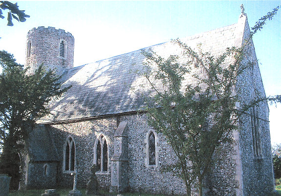
It could have been in a different deanery or archdeaconry both before and after this date. - The parish church is dedicated to St Mary.
- Church of St Mary
- Description and pictures.
- Church of St Mary
- Services, etc.
- Church of St Mary
- Description and pictures.
- Church of St Mary
- Picture of the church.
- Marriages
- These are not included in Boyd's Marriage Index or Phillimore's Marriage Registers.
See also Norfolk Parish Links: Church Records
For the civil registration of births, marriages and deaths between 1837 and 1930 (and for the censuses from 1851 to 1901), Fishley was in Blofield Registration District.
- Upton with Fishley Parish Council
- Minutes, meetings, etc.
- 1845: White's History, Gazetteer, and Directory of Norfolk
- 1850: Hunt's Directory of East Norfolk with Part of Suffolk
- 1854: White's History, Gazetteer, and Directory of Norfolk (this is a link to an archived copy)
- 1864: White's History, Gazetteer, and Directory of Norfolk
- 1883: White's History, Gazetteer, and Directory of Norfolk
- 1883: Kelly's Directory for Cambridgeshire, Norfolk and Suffolk (this is a link to an archived copy)
See also Norfolk Parish Links: Directories
- Ask for a calculation of the distance from Fishley to another place.
Fishley is in Walsham Hundred.
- Parish outline and location.
- See Parish Map for Walsham Hundred
- Description of Walsham Hundred
- 1845: White's History, Gazetteer, and Directory of Norfolk
- Inclosure and Drainage
- See Upton
You can see maps centred on OS grid reference TG399117 (Lat/Lon: 52.649729, 1.545467), Fishley which are provided by:
- OpenStreetMap
- Google Maps
- StreetMap (Current Ordnance Survey maps)
- Bing (was Multimap)
- Old Maps Online
- National Library of Scotland (Old Ordnance Survey maps)
- Vision of Britain (Click "Historical units & statistics" for administrative areas.)
- English Jurisdictions in 1851 (Unfortunately the LDS have removed the facility to enable us to specify a starting location, you will need to search yourself on their map.)
- Magic (Geographic information) (Click + on map if it doesn't show)
- GeoHack (Links to on-line maps and location specific services.)
- All places within the same township/parish shown on an Openstreetmap map.
- Nearby townships/parishes shown on an Openstreetmap map.
- Nearby places shown on an Openstreetmap map.
- After 1834 Fishley became part of the Blofield Union, and the workhouse was at Lingwood.
See Upton