
Hide
--- TEST SYSTEM --- TEST SYSTEM --- TEST SYSTEM ---
Hide
Cockthorpe
hide
Hide
hide
Hide
hide
Hide
Hide
"COCKTHORPE, a small parish and hamlet, 6 miles W.N.W. of Holt, has only 42 inhabitants, a few cottages, and two FARMS, containing about 500 acres, occupied by Ness Harvey and Thomas R. Simpson, and belonging to Lord Calthorpe, the lord of the manor and patron of the CHURCH, (All Saints,) which is a rectory, valued in the King's Book at £5, but consolidated with Blakeney rectory, Little Langham vicarage, and Glanford [sic]curacy, in the incumbency of the Rev. Joseph Cotterill, of Blakeney, with 26A. of glebe. The joint livings were valued in 1831 at £506 per annum." [William White, History, Gazetteer, and Directory of Norfolk (1845) - Transcription copyright © Pat Newby]
Hide
- Blakeney Area Historical Society
- Cockthorpe Churchyard - the monuments and monumental inscriptions.
[Blakeney Area Historical Society, The Glaven Historian, Vol 9, 2006]
See also Norfolk Parish Links: Cemeteries
- 1891: Surname List (this is a link to an archived copy)
- 1891
See also Norfolk Parish Links: Censuses
- In 1883 the parish was in the Deanery of Walsingham, in the archdeaconry of Norwich.
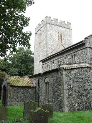
It could have been in a different deanery or archdeaconry both before and after this date. - The parish church is dedicated to All Saints.
- Church of All Saints
- Description and pictures.
- Church of All Saints
- Picture of the church.
- Parish Register Transcripts
- Marriages.
- Archdeacons' Transcripts
- Baptisms 1764-1811, Marriages 1768-1802 and Burials 1765-1808.
[Parish Register Transcription Society, Dart Series, 2000?] - Marriages
- These are not included in Boyd's Marriage Index or Phillimore's Marriage Registers.
See also Norfolk Parish Links: Church Records
For the civil registration of births, marriages and deaths between 1837 and 1930 (and for the censuses from 1851 to 1901), Cockthorpe was in Walsingham Registration District.
- 1845: White's History, Gazetteer, and Directory of Norfolk
- 1854: White's History, Gazetteer, and Directory of Norfolk (this is a link to an archived copy)
- 1883: White's History, Gazetteer, and Directory of Norfolk
- 1883: Kelly's Directory for Cambridgeshire, Norfolk and Suffolk (this is a link to an archived copy)
See also Norfolk Parish Links: Directories
- Ask for a calculation of the distance from Cockthorpe to another place.
Cockthorpe is in North Greenhoe Hundred.
- Parish outline and location.
- See Parish Map for North Greenhoe Hundred
- Description of North Greenhoe Hundred
- 1845: White's History, Gazetteer, and Directory of Norfolk
You can see maps centred on OS grid reference TF984422 (Lat/Lon: 52.940363, 0.95066), Cockthorpe which are provided by:
- OpenStreetMap
- Google Maps
- StreetMap (Current Ordnance Survey maps)
- Bing (was Multimap)
- Old Maps Online
- National Library of Scotland (Old Ordnance Survey maps)
- Vision of Britain (Click "Historical units & statistics" for administrative areas.)
- English Jurisdictions in 1851 (Unfortunately the LDS have removed the facility to enable us to specify a starting location, you will need to search yourself on their map.)
- Magic (Geographic information) (Click + on map if it doesn't show)
- GeoHack (Links to on-line maps and location specific services.)
- All places within the same township/parish shown on an Openstreetmap map.
- Nearby townships/parishes shown on an Openstreetmap map.
- Nearby places shown on an Openstreetmap map.
- After 1834 Cockthorpe became part of the Walsingham Union, and the workhouse was at Great Snoring.
These figures are from the population tables which were produced after the 10-yearly national censuses. The "Families" heading includes families and single occupiers.
|
|
There may be more people living in detached parts of the parish (if there were any) and, if so, the number may or may not be included in the figures above. It is quite difficult to be sure from the population tables.