
Hide
--- TEST SYSTEM --- TEST SYSTEM --- TEST SYSTEM ---
Hide
Breckles
hide
Hide
hide
Hide
hide


Hide
Hide
"BRECKLES, or Breccles, a small village and parish, 5 miles S. by E. of Watton, has 160 souls, and 1506 acres of land, belonging to Edw. Kerrison, Esq., son of Sir E. Kerrison, Bart., the lord of the manor and patron of the Church, (St. Margaret,) which is a discharged vicarage, valued in K.B. at £7. 7s. 11d., and in 1831, at £41. From 1767 to 1824 it was augmented with £1000 of Q.A.B. The Rev. Robert Ward is the incumbent. In 1806, John Stubbings died here, in his 108th year." [William White, History, Gazetteer, and Directory of Norfolk (1845) - Transcription copyright © Mike Bristow]
Hide
Breckles is about 7 miles N.E. of Thetford.
The name may also be spelled Breccles, and both spellings may be found in the same document.
It is also the name of the deanery, so a reference to Breckles could mean this parish, or this area of Norfolk.
Hide
- 1891: Surname List (this is a link to an archived copy)
See also Norfolk Parish Links: Censuses
- In 1883 the parish was in the Deanery of Breckles, in the archdeaconry of Norwich.
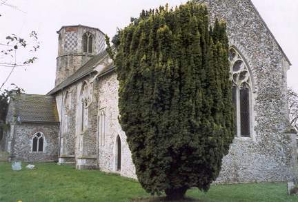
It could have been in a different deanery or archdeaconry both before and after this date. - The parish church is dedicated to St Margaret.
- Church of St Margaret
- Description and pictures.
- Church of St Margaret
- Pictures of the church.
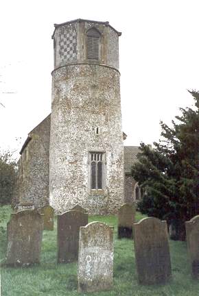
- Church of St Margaret and the tower
- Pictures of the church.
- Church of St Margaret
- Services, etc.
- Marriages
- These are not included in Boyd's Marriage Index or Phillimore's Marriage Registers.
See also Norfolk Parish Links: Church Records
For the civil registration of births, marriages and deaths between 1837 and 1930 (and for the censuses from 1851 to 1901), Breckles was in Wayland Registration District.
- Breckles
- Description, history and pictures.
- Stow Bedon History Group
- The parish of Stow Bedon, Breckles and Lower Stow Bedon.
[Stow Bedon History Group, 2005]
- 1845: White's History, Gazetteer, and Directory of Norfolk
- 1854: White's History, Gazetteer, and Directory of Norfolk (this is a link to an archived copy)
- 1864: White's History, Gazetteer, and Directory of Norfolk
- 1883: White's History, Gazetteer, and Directory of Norfolk
- 1883: Kelly's Directory for Cambridgeshire, Norfolk and Suffolk (this is a link to an archived copy)
- 1900: Kelly's Directory of Norfolk
- 1937: Kelly's Directory of Norfolk (this is a link to an archived copy)
See also Norfolk Parish Links: Directories
- Ask for a calculation of the distance from Breckles to another place.
Breckles is in Wayland Hundred.
- Parish outline and location.
- See Parish Map for Wayland Hundred
- Description of Wayland Hundred
- 1845: White's History, Gazetteer, and Directory of Norfolk
- Jessopp, Augustus
- Notes on the history of Breccles Hall, Norfolk.
[Norwich, Norfolk and Norwich Archaeological Society, in "Norfolk Archaeology", vol.8, 1879]
You can see maps centred on OS grid reference TL960943 (Lat/Lon: 52.511311, 0.886886), Breckles which are provided by:
- OpenStreetMap
- Google Maps
- StreetMap (Current Ordnance Survey maps)
- Bing (was Multimap)
- Old Maps Online
- National Library of Scotland (Old Ordnance Survey maps)
- Vision of Britain (Click "Historical units & statistics" for administrative areas.)
- English Jurisdictions in 1851 (Unfortunately the LDS have removed the facility to enable us to specify a starting location, you will need to search yourself on their map.)
- Magic (Geographic information) (Click + on map if it doesn't show)
- GeoHack (Links to on-line maps and location specific services.)
- All places within the same township/parish shown on an Openstreetmap map.
- Nearby townships/parishes shown on an Openstreetmap map.
- Nearby places shown on an Openstreetmap map.
- Roll of Honour
- World War 1.
- After 1834 Breckles became part of the Wayland Union, and the workhouse was at Rockland All Saints.
These figures are from the population tables which were produced after the 10-yearly national censuses. The "Families" heading includes families and single occupiers.
|
|
There may be more people living in detached parts of the parish (if there were any) and, if so, the number may or may not be included in the figures above. It is quite difficult to be sure from the population tables.