
Hide
--- TEST SYSTEM --- TEST SYSTEM --- TEST SYSTEM ---
Hide
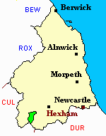
Whitfield
hide
Hide
hide
Hide
Hide
Hide
"WHITFIELD parish is bounded on the north and west by the parish of Haltwhistle, on the south by that of Allendale and the county of Cumberland, and on the east by Allendale parish. It comprises an area of 12,125 acres, and its rateable value is £3,561 10s. The number of inhabitants in 1801, was 393; in 1811, 330; in 1821, 289; in 1831, 388; in 1841, 333; and in 1851, 340 souls. William Ord Esq., is lord of the manor and owner of the soil. This parish consists, in great measure, of uncultivated moorlands, on which numerous flocks of sheep are grazed, and is partly intersected by the streams of the East and West Allen, which unite at Cupola. Lead ore was formerly procured in considerable quantities from a mine at Limestone Cross, and smelted at Cupola. There is a spring strongly impregnated with iron, at Redmires, and the road from Alston to Haydon Bridge runs through the parish. Hodgson tells us that in 1749, scarcely more than a century ago, 'the roads through this parish were mere trackways, and the principal employment of the people was the conveyance of lead ore to the neighbouring smelt-mills, in sacks, on the backs of ponies. There was not a cart in the country. The farms were very small - seldom above twenty pounds a-year, and the dwelling-houses and farm offices upon them, of the most wretched description.' The greater portion of these have been pulled down and replaced by large and substantial farmhouses, and commodious offices, mills, &c. have been erected, and a turnpike-road made through the parish. The manor of Whitfield was granted by William, King of Scotland, to the priory of Hexham, of which it was held by a family that bore the local name, at an annual rent of 16s. 4d. It remained in the possessions of the Whitfields for many generations, but was ultimately sold by Thomas Whitfield to the Ord family, with whom it still continues." [From History, Topography, and Directory of Northumberland, Whellan, 1855].
Hide
- Northumberland County Record Office holds copies of Census Returns 1841 - 1891 and provides a useful User Guide
- The 1851 Census Index (microfiche CN19) Whitfield, Kirkhaugh, Knarsdale, Lambley and Haltwhistle (PRO piece HO107/2416 folios 1-273) (Type A) (Book) published by the https://www.ndfhs.org.uk/may be of value to researchers interested in this parish.
- 1891 Census Whitfield, Kirkhaugh, Knarsdale, Slaggyford, Lambley and Harper (PRO piece RG12/4250) (Type B) (Book) (Volume 60) published by the https://www.ndfhs.org.uk/may be of value to researchers interested in this parish.
- The Ancestral Indexes website provides information about Whitfield, Holy Trinity.
- Whitfield - Church Records - links and information.
- This area is within Northumberland West Registration District.
- Certificates of birth, death and marriage can be ordered from Northumberland County Council.
- The section of The National Gazetteer (1868) relating to this parish - transcribed by Colin Hinson.
- Ask for a calculation of the distance from Whitfield to another place.
- The history of Whitfield Parish is included in:- Hodgson, J., History of Northumberland, Part 2, Volume 3. Newcastle, 1840. (Available on fiche from Ancestral Indexes).
You can see maps centred on OS grid reference NY765550 (Lat/Lon: 54.888789, -2.367983), Whitfield which are provided by:
- OpenStreetMap
- Google Maps
- StreetMap (Current Ordnance Survey maps)
- Bing (was Multimap)
- Old Maps Online
- National Library of Scotland (Old Ordnance Survey maps)
- Vision of Britain (Click "Historical units & statistics" for administrative areas.)
- English Jurisdictions in 1851 (Unfortunately the LDS have removed the facility to enable us to specify a starting location, you will need to search yourself on their map.)
- Magic (Geographic information) (Click + on map if it doesn't show)
- GeoHack (Links to on-line maps and location specific services.)
- All places within the same township/parish shown on an Openstreetmap map.
- Nearby townships/parishes shown on an Openstreetmap map.
- Nearby places shown on an Openstreetmap map.