
Hide
--- TEST SYSTEM --- TEST SYSTEM --- TEST SYSTEM ---
Hide
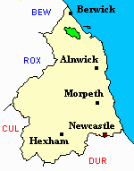
Lowick
hide
Hide
hide
Hide
Hide
Hide
"LOWICK parish comprises the townships of Barmoor, Bowsdon, Holborn, and Lowick; and is bounded on the north by Islandshire, on the west by Ford, on the south by Doddington and Chatton, and on the east by Belford. Its area is 12,526 acres, and its population in 1801, was 1,382; in 1811, 1,519; in 1821, 1,799; in 1831, 1,864; in 1841, 1,941; and in 1851, 1,941 souls. The soil consists chiefly of a loamy clay, and the surface presents a bleak and monotonous appearance. There was a new colliery opened here, in 1854, called Licker Colliery." [From History, Topography, and Directory of Northumberland, Whellan, 1855].
Hide
- Northumberland County Record Office holds copies of Census Returns 1841 - 1891 and provides a useful User Guide
- The 1851 Census Index (microfiche CN34)
- 1891 Census Northumberland – Ford (Carham, Wark, Downham, Presson, Branxton, Ford, Etal and New Etal, Crookham, Kimmerston, Berryhill, Lowick, Bowsden, Barmoor, Holburn, Millfield, Crookhouse, Lanton, Coupland, Coupland, Howtell, Kilham, Paston, Coldsmouth and Thompsons Wall, Kirknewton, Westnewton, Yeavering, Hethpool and Greys Forest) (PRO piece RG12/4270) (Type B) (Book) (Volume 80) BOTH published by the https://www.ndfhs.org.uk/ may be of value to researchers interested in this parish.
- The article, Two Clerical Friends by Rev. H.S. Ross, published in History of the Berwickshire Naturalists' Club Vol. XLI, part 2 (1978) pp. 79-88, compares and contrasts the lives of two Protestant Dissenters: Israel Craig at Lowick (from 1793-1843) and William Whitehouse at Spittal (from 1813 to 1857).
- Lowick, St John:- The Ancestral Indexes website provides information under the headings History and Monumental Inscriptions.
- Lowick - Church Records - links and information.
- This area is within Northumberland North First Registration District.
- Certificates of birth, death and marriage can be ordered locally from Northumberland County Council.
- The Northumberland Communities website includes pages relating to Bowsden and Lowick. They provide "a range of learning resource material that reflects Northumberland's heritage, providing a base for studying the County's history. The website provides a starting point for understanding the development of communities in Northumberland. It also seeks to illustrate the range of sources for family and local history research that are available via Northumberland Archives Service."
- The section of The National Gazetteer (1868) relating to this parish - transcribed by Colin Hinson.
- Ask for a calculation of the distance from Lowick to another place.
- The history of Lowick Parish is included in:- Northumberland County History Committee, History of Northumberland, Volume 14. Newcastle, A. Reid, 1935. (Available on fiche from Ancestral Indexes).
You can see maps centred on OS grid reference NU006386 (Lat/Lon: 55.641029, -1.992388), Lowick which are provided by:
- OpenStreetMap
- Google Maps
- StreetMap (Current Ordnance Survey maps)
- Bing (was Multimap)
- Old Maps Online
- National Library of Scotland (Old Ordnance Survey maps)
- Vision of Britain (Click "Historical units & statistics" for administrative areas.)
- English Jurisdictions in 1851 (Unfortunately the LDS have removed the facility to enable us to specify a starting location, you will need to search yourself on their map.)
- Magic (Geographic information) (Click + on map if it doesn't show)
- GeoHack (Links to on-line maps and location specific services.)
- All places within the same township/parish shown on an Openstreetmap map.
- Nearby townships/parishes shown on an Openstreetmap map.
- Nearby places shown on an Openstreetmap map.
- A transcript of Lowick War Memorial provided by Ancestral Indexes.
LEST WE FORGET
Lowick St John
29 Oct 1918 William Hall, Private 100543 2nd Bn Durham Light Infantry, age 21 son of John and Margaret Hall [grave E.E section]