
Hide
--- TEST SYSTEM --- TEST SYSTEM --- TEST SYSTEM ---
Hide
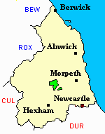
Kirkwhelpington
hide
Hide
hide
Hide
Hide
Hide
"KIRK WHELPINGTON is a parish, comprising the townships of Bavington (Great), Capheaton, Catcherside, Coldwell, Crogdean, Fawns, Hawick, Kirk Whelpington, and Whelpington (West). It is bounded by the parishes of Elsdon, Hartburn, Corsenside, and Thockrington, and comprises an area of 13,351 acres, The population in 1801, was 714; in 1811, 814; in 1821, 793; in 1831, 789; in 1841, 705; and in 1851, 679 souls. The township of Hawick was given to this parish in 1847, in exchange for the townships of Little Harle and West Harle, which were transferred to Kirk Harle parish. This extensive district consists principally of moorlands, which, however, afford excellent pasturage for sheep and cattle, and in some parts of the parish the soil is well suited for the purposes of the dairy The salubrity of the atmosphere in this part of the country is much celebrated, and instances of longevity are not at all uncommon." [From History, Topography, and Directory of Northumberland, Whellan, 1855].
Hide
- Northumberland County Record Office hold copies of Census Returns 1841 - 1891 and provide a useful User Guide
- The 1851 Census Index (microfiche CN14 and CN20) Falstone, Thorneyburn, Greystead, Bellingham, Corsenbridge, Wark, Thockrington, Kirkharle, Elsdon (part), Kirkwhelpington and Birtley (PRO piece HO107/2417 folios 1-292) (Type A) (Book)
- 1891 Census Northumberland – Kirkwhelpington (Corsenside, Redesdale, Birtley, Thockrington, West Harle, Kirkwhelpington, Coldwell, Kirkharle and Wark (PRO piece RG12/4253) (Type B) (Book) (Volume 63) BOTH published by the https://www.ndfhs.org.uk/ may be of value to researchers interested in this parish.
- Kirkwhelpington - Church Records - links and information.
- This area is within Northumberland West Registration District.
- Certificates of birth, death and marriage can be ordered from Northumberland County Council.
- Photographs of Ray Fell and Wanney Crags from Les Bell's Northumberland Cam website.
- The section of The National Gazetteer (1868) relating to this parish - transcribed by Colin Hinson.
- Ask for a calculation of the distance from Kirkwhelpington to another place.
- The history of Kirkwhelpington Parish is included in:- Hodgson, J., History of Northumberland, Part 2, Volume 1. Newcastle, 1827. (Available on fiche from Ancestral Indexes).
- Kirkwhelpington - Maps - links and information.
You can see maps centred on OS grid reference NY993837 (Lat/Lon: 55.1472, -2.013181), Kirkwhelpington which are provided by:
- OpenStreetMap
- Google Maps
- StreetMap (Current Ordnance Survey maps)
- Bing (was Multimap)
- Old Maps Online
- National Library of Scotland (Old Ordnance Survey maps)
- Vision of Britain (Click "Historical units & statistics" for administrative areas.)
- English Jurisdictions in 1851 (Unfortunately the LDS have removed the facility to enable us to specify a starting location, you will need to search yourself on their map.)
- Magic (Geographic information) (Click + on map if it doesn't show)
- GeoHack (Links to on-line maps and location specific services.)
- All places within the same township/parish shown on an Openstreetmap map.
- Nearby townships/parishes shown on an Openstreetmap map.
- Nearby places shown on an Openstreetmap map.