
Hide
--- TEST SYSTEM --- TEST SYSTEM --- TEST SYSTEM ---
Hide
Hartburn
hide
Hide
hide
Hide
Hide
Hide
"HARTBURN, a parish partly in the west division of Morpeth Ward, and partly in the east division of Tindale Ward, is a very large district comprising twenty-four townships, whose united area is 25,778 acres; and has for its boundaries the parishes of Bolam, Kirkwhelpington, Meldon, Mitford, Nether Whitton, and Rothbury. Population in 1801, 1,340; in 1811, 1,430; in 1821, 1,474; in 1831, 1,440; in 1841, 1,322; and in 1851, 1,506 souls. The greater portion of this extensive district is fertile, luxuriant, and picturesque, abounding with excellent limestone, while the townships of Harwood and Green Leighton consist principally of bleak moor lands. Coal and lead are found in this parish." [From History, Topography, and Directory of Northumberland, Whellan, 1855].
"HARTBURN, a parish, in the county of NORTHUMBERLAND, comprising the townships, of High Angerton, Low Angerton, Corridge, Hartburn, Hartburn-Grange, Highlaws, Longwitton, North Middleton, South Middleton, Rothley, East Thornton, West Thornton, Todridge, and Whitridge, in the western division of MORPETH ward, and the townships of Cambo, Deanham, Favinley, otherwise Farnlaws, Greenleighton, Hartington, Hartington Hall, Harwood, East Shafto, West Shafto, and Wallington-demesne, in the north-eastern division of TINDALE ward,......." [Samuel Lewis Topographical Dictionary of England 1831 © Mel Lockie]
Hide
- Northumberland County Record Office holds copies of Census Returns 1841 - 1891 and provides a useful User Guide
- The 1851 Census Index (microfiche CN14, CN21 and CN27) Hartburn, Netherwitton, Longhorsley, Hebron, Mitford and Meldon (PRO piece HO107/2418 folios 1-145) (Type B) (Book) published by the https://www.ndfhs.org.uk/ may be of value to researchers interested in this parish.
- The Ancestral Indexes website provides information about Cambo, Holy Trinity.
- Hartburn - Church Records - links and information.
- This area is divided between Northumberland North Second Registration District and Northumberland Central Registration District.
- Certificates of birth, death and marriage can be ordered from Northumberland County Council.
- Photographs of Hartburn, Harwood and Rothley from Les Bell's Northumberland Cam website.
- Wallington, the historic home of the Trevelyan family is set within gardens, woods and lawns from Mirror Image.
- The section of The National Gazetteer (1868) relating to this parish - transcribed by Colin Hinson.
- Ask for a calculation of the distance from Hartburn to another place.
- The history of Hartburn Parish is included in:- Hodgson, J., History of Northumberland, Part 2, Volume 1. Newcastle, 1827. (Available on fiche from Ancestral Indexes).
- Hartburn - Maps - links and information.
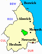
You can see maps centred on OS grid reference NZ041873 (Lat/Lon: 55.18031, -1.936941), Hartburn which are provided by:
- OpenStreetMap
- Google Maps
- StreetMap (Current Ordnance Survey maps)
- Bing (was Multimap)
- Old Maps Online
- National Library of Scotland (Old Ordnance Survey maps)
- Vision of Britain (Click "Historical units & statistics" for administrative areas.)
- English Jurisdictions in 1851 (Unfortunately the LDS have removed the facility to enable us to specify a starting location, you will need to search yourself on their map.)
- Magic (Geographic information) (Click + on map if it doesn't show)
- GeoHack (Links to on-line maps and location specific services.)
- All places within the same township/parish shown on an Openstreetmap map.
- Nearby townships/parishes shown on an Openstreetmap map.
- Nearby places shown on an Openstreetmap map.