Hide
--- TEST SYSTEM --- TEST SYSTEM --- TEST SYSTEM ---
Hide
Elsdon
hide
Hide
hide
Hide

Hide
Hide
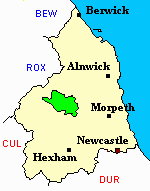
"ELSDON, an extensive parish forming the whole south division of Coquetdale Ward, is bounded on the north by Holystone chapelry, on the west by Ramshope and Scotland, on the south by Tindale Ward, and on the east by Rothbury. The parish, which is about 20 miles in length, and from six to twelve miles in breadth, comprises an area of 74,917 acres, and its population in 1801, was 1,694; in 1811, 1,821; in 1821, 1,848; in 1831, 1,724; in 1841, 1,680; and in 1851, 1,643 souls. It embraces the townships of Elsdon Ward, situated on a branch of the river Reed; and those of Monkridge Ward, Otterburn Ward, Rochester Ward, Troughend Ward, and Woodside Ward. It is an extensive vale, enclosed on the north side by an irregular ridge of hills, and on the south by a ridge much more regular. The hills on both sides are of considerable elevation, and invariably clad in heath, except a small part of those near the source of the river Reed, where they begin to participate in the nature of those in Roxburghshire. Several brooks, or burns, fall into the Reed from the hills on both sides. The parish appears to have been at one time almost an entire forest, and several remnants of it still remain on the banks of the Reed, consisting of birch, alder, and willow, with here and there a mountain ash." [From History, Topography, and Directory of Northumberland, Whellan, 1855].
Hide
- Northumberland County Record Office hold copies of Census Returns 1841 - 1891 and provides a useful User Guide
- The 1851 Census Index (microfiche CN20, CN27) Falstone, Thorneyburn, Greystead, Bellingham, Corsenbridge, Wark, Thockrington, Kirkharle, Elsdon (part), Kirkwhelpington and Birtley (PRO piece HO107/2417 folios 1-292) (Type A) (Book) Rothbury and Elsdon (part) (PRO piece HO107/2423) (Type B) (Book)
- 1891 Census Rothbury, Elsdon (Monkridge, Elsdon, Woodside, Hepple, Holystone, Farnham, Wreighill, Linsheels, Linbridge, Kidland, Fairhaugh, Barrow, Alwinton, Clennell, Harbottle, Peels, Sharperton, Burradon and Biddlestone) (PRO piece RG12/4273) (Type B) (Book) (Volume 83) BOTH published by the https://www.ndfhs.org.uk/ may be of value to researchers interested in this parish.
- The Ancestral Indexes website provides information about Elsdon, St Cuthbert, Horsley, Holy Trinity and Otterburn, St John.
- Elsdon - Church Records - links and information.
- This area is divided between Northumberland North Second Registration District and Northumberland West Registration District.
- Certificates of birth, death and marriage can be ordered from Northumberland County Council.
- Photographs of Elsdon, Elsdon Burn (Cheviots), Otterburn and Winter's Gibbet from Les Bell's Northumberland Cam website.
- The section of The National Gazetteer (1868) relating to this parish - transcribed by Colin Hinson.
- Ask for a calculation of the distance from Elsdon to another place.
- A history of the village of Elsdon from the Northumberland National Park website.
- A history of the village of High Rochester from the Northumberland National Park website.
- The history of Elsdon Parish is included in:- Hodgson, J., History of Northumberland, Part 2, Volume 1. Newcastle, 1827. (Available on fiche from Ancestral Indexes).
- Elsdon - Maps - links and information.
You can see maps centred on OS grid reference NY829975 (Lat/Lon: 55.2712, -2.271037), Elsdon which are provided by:
- OpenStreetMap
- Google Maps
- StreetMap (Current Ordnance Survey maps)
- Bing (was Multimap)
- Old Maps Online
- National Library of Scotland (Old Ordnance Survey maps)
- Vision of Britain (Click "Historical units & statistics" for administrative areas.)
- English Jurisdictions in 1851 (Unfortunately the LDS have removed the facility to enable us to specify a starting location, you will need to search yourself on their map.)
- Magic (Geographic information) (Click + on map if it doesn't show)
- GeoHack (Links to on-line maps and location specific services.)
- All places within the same township/parish shown on an Openstreetmap map.
- Nearby townships/parishes shown on an Openstreetmap map.
- Nearby places shown on an Openstreetmap map.
