
Hide
--- TEST SYSTEM --- TEST SYSTEM --- TEST SYSTEM ---
Hide
Corbridge
hide
Hide
hide
Hide
Hide
Hide
"CORBRIDGE is a parish, comprising the townships of Aydon, Aydon Castle, Clarewood, Corbridge, Dilston, Halton, Halton Shields, Thornborough, Whittington Great, and Whittington Little. It is about eight miles in length from north to south, but its average breadth does not exeeed two and a half miles, and comprises an area of 13,130 acres. Its population in 1801, was 1,744; in 1811, 1,979; in 1821, 2,037; in 1831, 2,091; in 1841, 2,103; and in 1851, 2,163 souls. The whole of this district is in an excellent state of cultivation, and contains great quantities of lead, coal, and lime. There are also several large plantations in various parts of the parish, the property of the Commissioners of Greenwich Hospital." [From History, Topography, and Directory of Northumberland, Whellan, 1855].
Hide
- Burial Registers 1872-1972 for Corbridge Civil Cemetery are available at Northumberland Record Office
- 1841 - 1891 Census are available at Northumberland Record Office
- The 1851 Census Index (microfiche CN16) Hexham, Corbridge, Slaley and St John Lee (part) (PRO piece HO107/2414 folios 272-610) (Type A) (Book)
- 1891 Census Northumberland – Hexham (Slaley, Corbridge, Dilston, Halton, Aydon, Thornborough, Clarewood, Great and Little Whittington, Sandhoe, Anick, Portgate and Hexham, part) (PRO piece RG12/4246) (Type B) (Book) (Volume 56)
BOTH published by the https://www.ndfhs.org.uk/ may be of value to researchers interested in this parish.
- The Ancestral Indexes website provides information about Corbridge, St Andrew, Dilston Hall, St Mary and Stagshaw, St Aidan.
- Corbridge - Church Records - links and information.
- This area is within Northumberland West Registration District.
- Certificates of birth, death and marriage can be ordered Locally from Northumberland County Council.
- Photographs of Corbridge from Les Bell's Northumberland Cam website.
- A field full of poppies (near Corbridge) from Mirror Image.
- The Northumberland Communities website includes pages relating to Corbridge. They provide "a range of learning resource material that reflects Northumberland's heritage, providing a base for studying the County's history. The website provides a starting point for understanding the development of communities in Northumberland. It also seeks to illustrate the range of sources for family and local history research that are available via Northumberland Archives Service."
- The section of The National Gazetteer (1868) relating to this parish - transcribed by Colin Hinson.
- Ask for a calculation of the distance from Corbridge to another place.
- The history of Corbridge Parish is included in Hodgson, J., History of Northumberland, Part 2, Volume 3. Newcastle, 1840. (Available on fiche from Ancestral Indexes).
- The history of Corbridge Parish is included in:- Northumberland County History Committee, History of Northumberland, Volume 10. Newcastle, A. Reid, 1914.
- Stagshaw Bank Fair - the largest one-day fair in England - was held on the day before Whit Sunday and on July 4th. These fairs took place at Stagshaw Bank Common which was partly in this parish and partly in the parish of St John Lee.
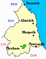
- Corbridge - Maps - links and information.
You can see maps centred on OS grid reference NY991663 (Lat/Lon: 54.991555, -2.01569), Corbridge which are provided by:
- OpenStreetMap
- Google Maps
- StreetMap (Current Ordnance Survey maps)
- Bing (was Multimap)
- Old Maps Online
- National Library of Scotland (Old Ordnance Survey maps)
- Vision of Britain (Click "Historical units & statistics" for administrative areas.)
- English Jurisdictions in 1851 (Unfortunately the LDS have removed the facility to enable us to specify a starting location, you will need to search yourself on their map.)
- Magic (Geographic information) (Click + on map if it doesn't show)
- GeoHack (Links to on-line maps and location specific services.)
- All places within the same township/parish shown on an Openstreetmap map.
- Nearby townships/parishes shown on an Openstreetmap map.
- Nearby places shown on an Openstreetmap map.
Lest We Forget