
Hide
--- TEST SYSTEM --- TEST SYSTEM --- TEST SYSTEM ---
Hide
Chatton
hide
Hide
hide
Hide
Hide
Hide
"CHATTON parish is bounded on the north by Lowick and Doddington parishes, on the west by Wooler and Eglingham, on the south by Eglingham and Chillingham, and on the east by Bambrough and Belford parishes. It is about seven and a half miles in length by the same in breadth, and has an area of 17,090 acres. Population in 1801, 1,135; in 1811, 1,378; in 1821, 1,460; in 1831, 1,632; in 1841, 1,725; and in 1851, 1765 souls. It comprises the townships of Chatton, Fowberry, Hazelrig, Hetton, Hetton House, Horton, Lyham, and Weetwood, whose returns are included in those of the parish. This district is intersected by the river Till, a rapid stream, which rises southward of the Cheviot Hills, and is fed by various springs from that wild expanse of country, as it encompasses it at a considerable distance, till it falls into the Tweed below Cornhill. This river flows through a pleasant valley in the midst of a rude, encircling waste, and its banks are adorned by several villages. In the neigbourhood of the Till, the soil is fertile and well cultivated, but the east and west portions of the parish are generally sterile and heathy. Coal and limestone are found in this district." [From History, Topography, and Directory of Northumberland, Whellan, 1855].
Hide
- Northumberland County Record Office holds copies of Census Returns 1841 - 1891 and provides a useful User Guide
- The 1851 Census Index (microfiche CN35)
- 1891 Census Wooler (Doddington, Nesbit, Fenton, Ewart, Earle, Humbleton, Middleton Hall, North and South Middleton, Ilderton, Roseden, Roddam, Selbys Forest, Akeld, Woller, Chatton, Chillingham, Hepburn, Newton, East and West Lilburn, Old and New Bewick, Brandon, Wooperton, Branton, Fawdon and Clinch, Reavley, Linhope, Greenside Hill and Hartside) (PRO piece RG12/4271) (Type B) (Book) (Volume 81) BOTH published by the https://www.ndfhs.org.uk/ may be of value to researchers interested in this parish.
- Chatton - Church Records - links and information.
- This area is within Northumberland North First Registration District.
- Certificates of birth, death and marriage can be ordered from Northumberland County Council.
- The Northumberland Communities website includes pages relating to Chatton. They provide "a range of learning resource material that reflects Northumberland's heritage, providing a base for studying the County's history. The website provides a starting point for understanding the development of communities in Northumberland. It also seeks to illustrate the range of sources for family and local history research that are available via Northumberland Archives Service."
- The section of The National Gazetteer (1868) relating to this parish - transcribed by Colin Hinson.
- Ask for a calculation of the distance from Chatton to another place.
- The history of Chatton Parish is included in:- Northumberland County History Committee, History of Northumberland, Volume 14. Newcastle, A. Reid, 1935. (Available on fiche from Ancestral Indexes).
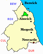
- Chatton - Maps - links and information.
You can see maps centred on OS grid reference NU061306 (Lat/Lon: 55.569019, -1.904753), Chatton which are provided by:
- OpenStreetMap
- Google Maps
- StreetMap (Current Ordnance Survey maps)
- Bing (was Multimap)
- Old Maps Online
- National Library of Scotland (Old Ordnance Survey maps)
- Vision of Britain (Click "Historical units & statistics" for administrative areas.)
- English Jurisdictions in 1851 (Unfortunately the LDS have removed the facility to enable us to specify a starting location, you will need to search yourself on their map.)
- Magic (Geographic information) (Click + on map if it doesn't show)
- GeoHack (Links to on-line maps and location specific services.)
- All places within the same township/parish shown on an Openstreetmap map.
- Nearby townships/parishes shown on an Openstreetmap map.
- Nearby places shown on an Openstreetmap map.