
Hide
--- TEST SYSTEM --- TEST SYSTEM --- TEST SYSTEM ---
Hide
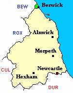
Berwick upon Tweed
hide
Hide
hide
Hide
Hide
Hide
"BERWICK-UPON-TWEED a county, parish, seaport and borough, is pleasantly situated on the north side of the Tweed, within half a mile of its confluence with the ocean, 337 miles north by west of London, fifty four south-east of Edinburgh, and sixty four north by west of Newcastle-upon-Tyne. From its position on the confines of England and Scotland, it is not considered to belong to either country, but to be a neutral town in the kingdom of Great Britain. .... The county or liberty of Berwick, forms nearly an equilateral triangle, whose sides are each about two miles in length, extending northward from the harbour's entrance to Lamberton grounds, and thence in a south-westerly direction to the Tweed, which forms the southern limit, whilst the sea and Berwickshire in Scotland, constitute respectively the northern and western boundaries. .... The parish of Berwick-upon-Tweed, comprises an area of 6,195 statute acres; its population in 1801, was 7,187; in 1811, 7,746; in 1821, 8,723; in 1831, 8,920; in 1841, 8,484; and in 1851, 10,294 souls. At the last mentioned period there were 1,384 inhabited houses, fifty-four uninhabited houses, and thirteen in the process of erection" [From History, Topography, and Directory of Northumberland, Whellan, 1855].
Hide
- Burial Registers 1856-1994, War Graves Register 1939-1946, Graves Register 1864-1986 and Burials Grant Books 1856-1948 for Berwick Civil Cemetery are available at Northumberland Record Office and at Berwick Record Office. A computer database of burials in this cemetery is being compiled at Berwick Record Office. This is searchable by name. The database currently covers 1856-1879 but additional burials are added every week.
- Northumberland County Record Office holds copies of Census Returns 1841 - 1891 and provides a useful User Guide
- The 1851 Census Index (microfiche CN29, CN30 and CN37) Berwick on Tweed Part 1 (PRO piece HO107/2421 folios 243-436) (Type B) (Book) Berwick on Tweed Part 2 (PRO piece HO107/2421 folios 440-605) (Type B) (Book)
Census 1851 Northumberland – Berwick on Tweed Part 3 and Norhamshire (PRO piece HO107/2421 folios 609-809) (Type B) (Book) - The 1891 Census Northumberland – Berwick upon Tweed (PRO piece RG12/4267) (Type B) (Book) (Volume 77) and Berwick upon Tweed (PRO piece RG12/4268) (Type B) (Book) (Volume 78) BOTH published by the https://www.ndfhs.org.uk/ may be of value to researchers interested in this parish.
- A transcript of the 1891 census for this area is available from Berwick Record Office(archived copy).
- A list of ships and crews in port during the 1881 census provided by Bob Sanders.
- The Ancestral Indexes website provides information about Berwick, St Mary.
- Berwick - Church Records - links and information.
- This area is within Northumberland North First Registration District.
- Certificates of birth, death and marriage can be ordered locally from Northumberland County Council.
- Photographs of Berwick-upon-Tweed from Les Bell's Northumberland Cam website.
- The Northumberland Communities website includes pages relating to Berwick. They provide "a range of learning resource material that reflects Northumberland's heritage, providing a base for studying the County's history. The website provides a starting point for understanding the development of communities in Northumberland. It also seeks to illustrate the range of sources for family and local history research that are available via Northumberland Archives Service."
- The section of The National Gazetteer (1868) relating to this parish - transcribed by Colin Hinson.
- Ask for a calculation of the distance from Berwick upon Tweed to another place.
- LNER Wartime Evacuation Documents N.EVAC 2 and N.EVAC 3 describing the arrangements for evacuating children from Newcastle and Gateshead to rural parts of Northumberland (including Berwick upon Tweed), Co Durham, Yorkshire, Cumberland and Westmorland. The second document includes lists of schools with details of their places and times of departure and their destinations.
You can see maps centred on OS grid reference NT976546 (Lat/Lon: 55.78484, -2.039938), Berwick upon Tweed which are provided by:
- OpenStreetMap
- Google Maps
- StreetMap (Current Ordnance Survey maps)
- Bing (was Multimap)
- Old Maps Online
- National Library of Scotland (Old Ordnance Survey maps)
- Vision of Britain (Click "Historical units & statistics" for administrative areas.)
- English Jurisdictions in 1851 (Unfortunately the LDS have removed the facility to enable us to specify a starting location, you will need to search yourself on their map.)
- Magic (Geographic information) (Click + on map if it doesn't show)
- GeoHack (Links to on-line maps and location specific services.)
- All places within the same township/parish shown on an Openstreetmap map.
- Nearby townships/parishes shown on an Openstreetmap map.
- Nearby places shown on an Openstreetmap map.
- The article Berwick Dispensary and Infirmary, 1814-1898 by Dr G.A.C. Binnie, published in History of the Berwickshire Naturalists' Club Vol. XLI, part 4 (1980) pp. 243-258, outlines the origins and history of Berwick Infirmary in this time period, with old drawings, lists of staff (doctors, dentists, dispensers, nurses, secretaries, treasurers) and insights into patient life.
- Two Centuries of Rope Making: Berwick upon Tweed, 1752-1956 by J.W. Bainbridge, published in History of the Berwickshire Naturalists' Club vol. 45, part 1 (1990) pp. 15-44. Full of illustrations, this article describes rope making at Berwick with information on specific roperies, ropemakers and ropery workers.