
Hide
--- TEST SYSTEM --- TEST SYSTEM --- TEST SYSTEM ---
Hide
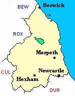
Alnham
hide
Hide
hide
Hide
Hide
Hide
"ALNHAM is a small village, near the source of the Aln river, 9 miles NNW. of Rothbury, and 13 miles W. of Alnwick. This small parish is bounded on the east by Whittingham, on the south by Allenton, on the west by Kidland, and on the north by Ingram. It is sometimes called Yarwell, and was formerly a place of consequence. The Church is dedicated to St Michael .... Alnham has evidently been an important place in the time of the ancient Britons and Romans. A little to the south is Black Chester, which was occupied by the Romans; and on a hill, a mile west of Alnham, is a semi-circular encampment, defended by two outward rampires and a deep fosse, with an inner circle of uncemented stones. The interior area is 100 yards in diameter, and shows many vestiges of buildings" [From History, Directory, and Gazetteer of the counties of Durham and Northumberland, Parson and White, 1828]
"ALNHAM, a parish in the ........ county of NORTHUMBERLAND, comprising the townships of Alnham, Prendick, Screnwood, and Unthank, ........." [Samuel Lewis Topographical Dictionary of England 1831 © Mel Lockie]
Hide
Whittingham Vale Northumberland by David Dippie Dixon Its History, Traditions & Folklore, published by Frank Graham 1979 ISBN 0859831221
- Northumberland County Record Office hold copies of Census returns 1841-1891 and provides a useful User Guide
- The 1851 Census Index (microfiche CN27) published by the Northumberland and Durham Family History Society may be of value to researchers interested in this parish
- 1891 Census Wooler (Screnwood, Alnham, Prendwick, Unthank, Netherton, North and South Side, Great and Little Ryle, Callaley and Yetlington, Lorbottle, Whittingham, Snitter, High and Low Trewitt, Cartington, Thropton, Warton, Flotterton Mount Healey, Rothbury, Whitton, Newtown, Tosson, Bickerton, Caistron, Fallowlees, Hollinghill, Hesleyhurst Row, Brinkburn High and Low Ward, Longframlington, Todburn, Wingates, Ritton Colt Park, Ritton White House, Ewesley, Healey and Combe Hill, Nunneykirk, Coatyards, Greenleighton, Harwood Fairnley, Hartington, Hartington Hall and Rothley) (PRO piece RG12/4272) (Type B) (Book) (Volume 82) published by the Northumberland and Durham Family History Society may be of value to researchers interested in this parish.
- Alnham - Church Records - links and information.
- Full Transcriptions of the Bishops Transcripts of Baptisms 1813 to 1875 and Marriages and Burials 1813 to 1829 [Bishops Transcripts ] can be found using the link below please scroll down list to relevant parish
- https://Northumberlandparishregistertranscriptslocalhistory.wordpress.com
- This area is within Northumberland North Second Registration District.
- Certificates of birth, death and marriage can be ordered from Northumberland County Council.
- The section of The National Gazetteer (1868) relating to this parish - transcribed by Colin Hinson.
- Ask for a calculation of the distance from Alnham to another place.
- National Burial Index for Alnham covers burials for the period 1727-1851 and is available on cd
- Copies of the Parish registers for Alnham are available from ndfhs.org.uk
- A printed version of the early registers can be viewed online at https://books.google.co.uk/
- The Local Studies Section at Newcastle City Library holds transcripts of the registers and Monumental Inscriptions
- A history of the village of Alnham from the Northumberland National Park website.
- The history of Alnham Parish is included in:- Northumberland County History Committee, History of Northumberland, Volume 14. Newcastle, A. Reid, 1935. (Available on fiche from Ancestral Indexes).
You can see maps centred on OS grid reference NT959131 (Lat/Lon: 55.412207, -2.066717), Alnham which are provided by:
- OpenStreetMap
- Google Maps
- StreetMap (Current Ordnance Survey maps)
- Bing (was Multimap)
- Old Maps Online
- National Library of Scotland (Old Ordnance Survey maps)
- Vision of Britain (Click "Historical units & statistics" for administrative areas.)
- English Jurisdictions in 1851 (Unfortunately the LDS have removed the facility to enable us to specify a starting location, you will need to search yourself on their map.)
- Magic (Geographic information) (Click + on map if it doesn't show)
- GeoHack (Links to on-line maps and location specific services.)
- All places within the same township/parish shown on an Openstreetmap map.
- Nearby townships/parishes shown on an Openstreetmap map.
- Nearby places shown on an Openstreetmap map.
Alnham War Memorial https://www.newmp.org.uk/search_results.php
Monumental Inscriptions for Alnham are availabe to purchase from Northumberland and Durham Family History Society or available to view at The Local Studies Centre Newcastle Central Library or Northumberland Local Studies Centre