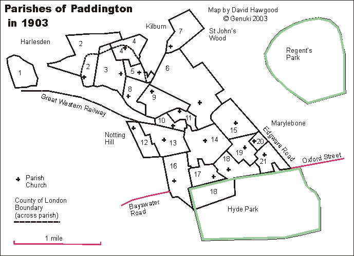
Click on a parish name in list below map for a fuller description of the parish, its grid reference and link to a modern street map will be added later. For clearer display or print, see map in pdf format.
- 1 St John, Kensal Green (detached part)
- 2 St John, Harrow Road, Kensal Green (part of parish was outside the County of London)
- 3 St Jude, Lancefield Street, Kensal Green (shown on 1903 map as a detached part of Chelsea) (part of parish was outside the County of London)
- 4 St Luke, Fernhead Road, Kilburn (part of parish was outside the County of London)
- 5 St Simon, Saltram Crescent (part of parish was outside the County of London)
- 6 St Saviour, Warwick Road
- 7 St Augustine, Kilburn
- 8 Emmanuel, Harrow Road
- 9 St Peter, Chippenham Road
- 10 St Paul, Marlborough Place, Harrow Road; also known as Christ Church, Harrow Road
- 11 St Mary Magdelene, Delamere Terrace
- 12 St Luke, Tavistock Road
- 13 St Stephen, Westbourne Park
- 14 Holy Trinity, Bishop's Road
- 15 St Mary, Paddington Green
- 16 St Matthew, Moscow Road, Bayswater
- 17 Christ Church, Lancaster Gate
- 18 St James, Westbourne Terrace (the southern part is within Hyde Park)
- 19 All Saints, Norfolk Square
- 20 St Michael and All Angels, Market Street
- 21 St John the Evangelist, Southwick Crescent
Click on a parish name for a fuller description of the parish; its grid reference and link to a modern street map will be added later. |
Parish boundaries traced from "A map of the Ecclesiastical Divisions within the County of London, 1903" published by Edward Stanford of London, reprinted as a facsimile by the London Topographical Society. List from that map is of parishes within the rural deanery of Paddington in 1903; they were all sub-divisions of the historic parish of Paddington (but areas around Kensal Green were previously detached parts of Chelsea). They are in the Archdeaconry of London, and Diocese of London. We have a list of other deaneries.
Map and list by David Hawgood. ©2003, page modified 17 Dec 2003