
Hide
--- TEST SYSTEM --- TEST SYSTEM --- TEST SYSTEM ---
Hide
Outline map of parishes of Bethnal Green, Middlesex in 1903
hide
Hide
Click on a parish name for a fuller description of the parish. For clearer display or print, see map in pdf format.
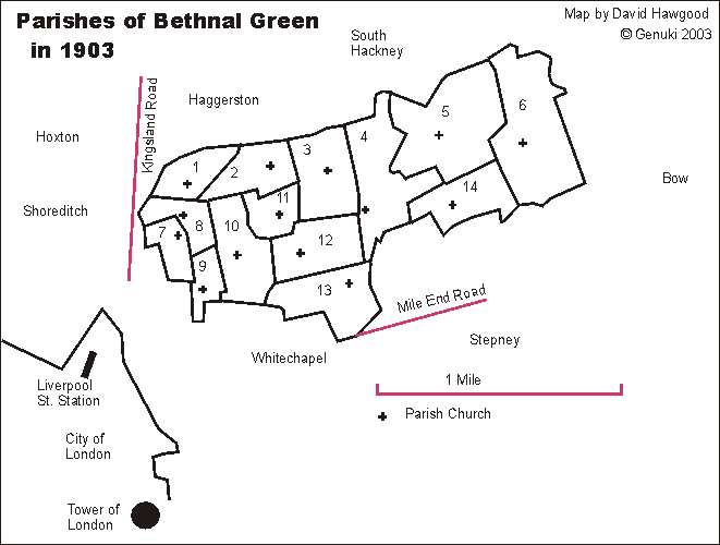
|
- 1- St Thomas, Baroness Road
- 2- St Peter, St Peter's Street
- 3- St Jude, Old Bethnal Green Road
- 4- St John, Cambridge Road
- 5- St James the Less, St James's Road
- 6- St Barnabas, Grove Road, Bow
- 7- St Philip, Mount Street
- 8- St Paul, Virginia Road
- 9- St Matthias, Hare Street
- 10 St Matthew, Church Row
- 11 St James the Great, Bethnal Green Road
- 12 St Andrew, Viaduct Street
- 13 St Bartholomew, Coventry Street
- 14 St Simon Zelotes, Morpeth Street
Parish boundaries traced from "A map of the Ecclesiastical Divisions within the County of London, 1903" published by Edward Stanford of London, reprinted as a facsimile by the London Topographical Society. List from that map is of parishes within the rural deanery of Bethnal Green in 1903; they were all sub-divisions of the historic parish of Bethnal Green. They are in the Archdeaconry of London, and Diocese of London. We have a list of other deaneries.
Map and list by David Hawgood. ©2003, page modified 17 Dec 2003