
Hide
--- TEST SYSTEM --- TEST SYSTEM --- TEST SYSTEM ---
Hide
St Peter Cornhill
hide
Hide
hide
Hide
Hide
Hide
"ST. PETER, Cornhill the church of, is situated near the south-east corner of Cornhill, and is of very ancient foundation, being given in 1298 by William Kingston to his tenement in Grass-street. The old church was destroyed by the fire of London, and the present substantial edifice erected in its stead by Sir Christopher Wren. The spire is surmounted by a ball, upon which is a vane in the form of a key, the ancient emblem of St. Peter. This church is a rectory, the patronage of which was anciently in the family of the Nevils; one of whom Lady Alice, relict of Sir Hugh Nevil, made a feoffment thereof in 1362, to Richard, Earl of Arundel and Surrey. After passing through various hands, it was conveyed in 1411 by Sir Richard Whittington, and others, to the Lord Mayor and Commonalty of the city of London, in whom the advowson still continues. It is in the city, diocese and archdeaconry of London, and the present rector is the Rev. John Page Wood, who was instituted in 1824." [James Elmes. A Topographical Dictionary of London and its Environs (1831) - transcribed by Brian Randell]
Hide
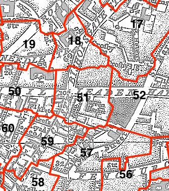
This parish - no. 51 in the above map - is located in Cornhill Ward.
The church was destroyed in 1666, rebuilt by Wren 1667-87.
Hide
London Metropolitan Archive holdings for St Peter Cornhill.
St Peter's Cornhill - from the London Gardens Online website.
Online Parish Register Images and Indexes for St Peter Cornhill parish are provided by, or at various subscription sites via, the FamilySearch wiki.
No non-Church of England denominations have been identified for St Peter Cornhill [FamilySearch Wiki].
Wikipedia page on St Peter Cornhill.
- Ask for a calculation of the distance from St Peter Cornhill to another place.
Summary history of St Peter Cornhill parish, from the Worshipful Company of Parish Clerks.
Public Houses, Inns & Taverns of the parish of St Peter Cornhill - provides "information from census records, trade directories, etc."
You can see maps centred on OS grid reference TQ331811 (Lat/Lon: 51.513077, -0.083932), St Peter Cornhill which are provided by:
- OpenStreetMap
- Google Maps
- StreetMap (Current Ordnance Survey maps)
- Bing (was Multimap)
- Old Maps Online
- National Library of Scotland (Old Ordnance Survey maps)
- Vision of Britain (Click "Historical units & statistics" for administrative areas.)
- English Jurisdictions in 1851 (Unfortunately the LDS have removed the facility to enable us to specify a starting location, you will need to search yourself on their map.)
- Magic (Geographic information) (Click + on map if it doesn't show)
- GeoHack (Links to on-line maps and location specific services.)
- All places within the same township/parish shown on an Openstreetmap map.
- Nearby townships/parishes shown on an Openstreetmap map.
- Nearby places shown on an Openstreetmap map.
Surnames from the 1881 census in the St Peter Cornhill and St Peter Cornhill London districts.
Clerical career summaries for the parish of St Peter Cornhill, from the Clergy of the Church of England Database website.
Sources for listings of taxpayer names for St Peter Cornhill parish, listed on the FamilySearch wiki.