
Hide
--- TEST SYSTEM --- TEST SYSTEM --- TEST SYSTEM ---
Hide
St Michael le Quern
hide
Hide
hide
Hide
Hide
Hide
"ST. MICHAEL-LE-QUERNE, the church of, stood before the fire of London at the west end of Cheapside between Blow-bladder- street (the short street from the end of Cheapside to Newgate-street, by St. Martin's-le-Grand,) and Paternoster-row, and had a narrow passage at the west end. In 1181 it was a chapelry, and the first rector was buried in it in 1461. In ancient records it is called St. Michael ad Bladum, that is at the corn, which became corrupted to querne, which is still the old, English or Saxon name of a hand corn-mill. It is also in some records called St. Michael de Macello, from its vicinity to the meat market. The old church was burned by the fire of London, and the site whereon it stood was by act of parliament laid into the street, and the parish united to that of St. Vedast Foster." [James Elmes. A Topographical Dictionary of London and its Environs (1831) - transcribed by Brian Randell]
Hide
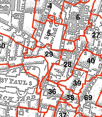
This parish - no. 29 in the above map - is located in Farringdon Within Ward.
The church was destroyed in 1666 and not rebuilt.
The parish was later united with St Vedast Foster Lane.
Hide
London Metropolitan Archive holdings for St Michael le Quern.
Online Parish Register Images and Indexes for St Michael le Quern parish are provided by, or at various subscription sites via, the LDS FamilySearch wiki.
No non-Church of England denominations have been identified for St Vedast Foster Lane with St Michael-le-Querne [LDS FamilySearch Wiki].
Littledale, W.A. (ed) The Registers of St. Vedast, Foster Lane, 1558 to 1836, and St. Michael Le Quern, 1685 to 1836. Harleian Society, London (1902-03) [Full text: Vol.1, Vol.2]
Wikipedia page on St Michael le Quern.
- Ask for a calculation of the distance from St Michael le Quern to another place.
Summary history of St Michael le Quern parish, from the Worshipful Company of Parish Clerks.
Public Houses, Inns & Taverns of the parish of St Michael le Quern - provides "information from census records, trade directories, etc."
Plan of the Parish of St Michael le Quern in 1853 from COLLAGE, the London Picture Archive
You can see maps centred on OS grid reference TQ321812 (Lat/Lon: 51.514587, -0.097321), St Michael le Quern which are provided by:
- OpenStreetMap
- Google Maps
- StreetMap (Current Ordnance Survey maps)
- Bing (was Multimap)
- Old Maps Online
- National Library of Scotland (Old Ordnance Survey maps)
- Vision of Britain (Click "Historical units & statistics" for administrative areas.)
- English Jurisdictions in 1851 (Unfortunately the LDS have removed the facility to enable us to specify a starting location, you will need to search yourself on their map.)
- Magic (Geographic information) (Click + on map if it doesn't show)
- GeoHack (Links to on-line maps and location specific services.)
- All places within the same township/parish shown on an Openstreetmap map.
- Nearby townships/parishes shown on an Openstreetmap map.
- Nearby places shown on an Openstreetmap map.
Surnames from the 1881 census in the St Michael Le Quern district.
Sources for listings of taxpayer names for St Michael le Quern parish, listed on the LDS FamilySearch wiki.