
Hide
--- TEST SYSTEM --- TEST SYSTEM --- TEST SYSTEM ---
Hide
St Martin Pomroy
hide
Hide
hide
Hide
Hide
Hide
"S\t. MARTIN POMARY, the church of, was formerly situated in Ironmonger-lane, Cheapside, and is supposed, by Stowe, to have received its addition from Pomary, an apple garden, but I am more indined to think from the family of the Pomeroys who might have had some connection with its patronage. The ancient church having been destroyed by the fire of London, the parish was united to that of St. Olive Jewry, by act of parliament." [James Elmes. A Topographical Dictionary of London and its Environs (1831) - transcribed by Brian Randell]
Hide
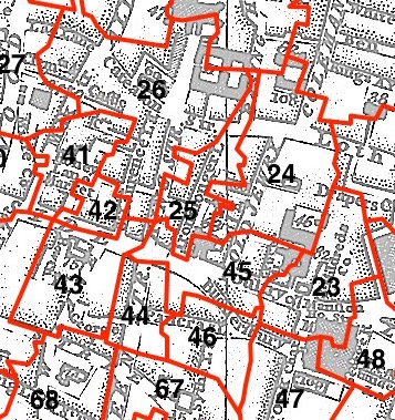
This parish - no. 25 in the above map - is located in Cheap Ward.
The church was destroyed in 1666 and not rebuilt.
The parish was later united with St Olave Jewry 1670, St Margaret Lothbury 1886.
Hide
London Metropolitan Archive holdings for St Martin Pomroy.
Online Parish Register Images and Indexes for St Martin Pomroy parish are provided by, or at various subscription sites via, the LDS FamilySearch wiki.
Presbyterian is the only identified non-Church of England denomination in St Olave Old Jewry with St Martin Pomeroy [LDS FamilySearch Wiki].
Wikipedia page on St Martin Pomroy.
Keene, D.J. and Harding, Vanessa. Historical Gazetteer of London Before the Great Fire Cheapside; Parishes of All Hallows Honey Lane, St Martin Pomary, St Mary Le Bow, St Mary Colechurch and St Pancras Soper Lane, Centre for Metropolitan History, London (1987) [Full text - British History Online]
- Ask for a calculation of the distance from St Martin Pomroy to another place.
Summary history of St Martin Pomroy parish, from the Worshipful Company of Parish Clerks.
Public Houses, Inns & Taverns of the parish of St Martin Pomroy - provides "information from census records, trade directories, etc."
Plan of the Parish of St Martin Pomroy in c1881 from COLLAGE, the London Picture Archive.
You can see maps centred on OS grid reference TQ325812 (Lat/Lon: 51.514507, -0.091627), St Martin Pomroy which are provided by:
- OpenStreetMap
- Google Maps
- StreetMap (Current Ordnance Survey maps)
- Bing (was Multimap)
- Old Maps Online
- National Library of Scotland (Old Ordnance Survey maps)
- Vision of Britain (Click "Historical units & statistics" for administrative areas.)
- English Jurisdictions in 1851 (Unfortunately the LDS have removed the facility to enable us to specify a starting location, you will need to search yourself on their map.)
- Magic (Geographic information) (Click + on map if it doesn't show)
- GeoHack (Links to on-line maps and location specific services.)
- All places within the same township/parish shown on an Openstreetmap map.
- Nearby townships/parishes shown on an Openstreetmap map.
- Nearby places shown on an Openstreetmap map.
Surnames from the 1881 census in the St Martin Pomroy and St Martin Pomroy London districts.
Clerical career summaries for the parish of St Martin Pomroy and St Olave Old Jewry With St Martin Pomeroy, from the Clergy of the Church of England Database website.
Sources for listings of taxpayer names for St Martin Pomroy parish, listed on the LDS FamilySearch wiki.