
Hide
--- TEST SYSTEM --- TEST SYSTEM --- TEST SYSTEM ---
Hide
St Alphage Sion College
hide
Hide
hide
Hide
Hide
Hide
"ST. ALPHAGE, the church of, is situated in Aldermanbury and London-wall, having an entrance from each. It derives its name from St. Alphage or Elphage, a noble Saxon saint, and Archbishop of Canterbury, who was murdered at Greenwich by the Danes, in the year 1013. The former church, which was a small and mean edifice, escaped the flames in 1666, but has been recently rebuilt from the designs of the younger Mr. George Dance. It has the singularity of having elliptical columns instead of circular, where, being attached to the wall in a very narrow street, great projection could not be obtained, and consequently produce a better effect of light and shade from the depth of the undercutting; than either pilasters or half columnss. The living is a rectory in the patronage of the Bishop of London, and its present rector is the Rev. Robert Watts, one of the prebendaries of St. Paul's, who was instituted in 1799." [James Elmes. A Topographical Dictionary of London and its Environs (1831) - transcribed by Brian Randell]
Hide
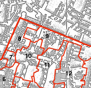
This parish, also known as St Alphage London Wall - no. 9 in the above map - is located in Cripplegate Ward.
The church was damaged in 1666, rebuilt in 1777, demolished 1924, with only the tower remaining.
The parish was later united with St Giles Cripplegate 1954.
Hide
London Metropolitan Archive holdings for St Alphage Sion College.
Online Parish Register Images and Indexes for St Alphage Sion College parish are provided by, or at various subscription sites via, the LDS FamilySearch wiki.
Baptist is the only identified non-Church of England denomination in St Alphage London Wall [LDS FamilySearch Wiki].
Wikipedia pages on St Alphage London Wall and Sion College.
- Ask for a calculation of the distance from St Alphage Sion College to another place.
Summary history of St Alphage Sion College parish, from the Worshipful Company of Parish Clerks.
Public Houses, Inns & Taverns of the parish of St Alphage Sion College - provides "information from census records, trade directories, etc."
You can see maps centred on OS grid reference TQ325816 (Lat/Lon: 51.517586, -0.092102), St Alphage Sion College which are provided by:
- OpenStreetMap
- Google Maps
- StreetMap (Current Ordnance Survey maps)
- Bing (was Multimap)
- Old Maps Online
- National Library of Scotland (Old Ordnance Survey maps)
- Vision of Britain (Click "Historical units & statistics" for administrative areas.)
- English Jurisdictions in 1851 (Unfortunately the LDS have removed the facility to enable us to specify a starting location, you will need to search yourself on their map.)
- Magic (Geographic information) (Click + on map if it doesn't show)
- GeoHack (Links to on-line maps and location specific services.)
- All places within the same township/parish shown on an Openstreetmap map.
- Nearby townships/parishes shown on an Openstreetmap map.
- Nearby places shown on an Openstreetmap map.
Surnames from the 1881 census in the St Alphage Sion and St Alphage Sion College districts.
Clerical career summaries for the parish of St Alphage Sion College, from the Clergy of the Church of England Database website.
Sources for listings of taxpayer names for St Alphage Sion College parish, listed on the LDS FamilySearch wiki.