
Hide
--- TEST SYSTEM --- TEST SYSTEM --- TEST SYSTEM ---
Hide
Winteringham
hide
Hide
hide
Hide
hide
Hide
Hide
Winteringham (or Wintringham), par. and vil., Lincolnshire - par., 3,970 ac. land and 1,705 water, pop. 671; vil., on river Humber, 7 miles W. of Barton on Humber; P.O.; was formerly a market town, and has some river trade.
From: John BARTHOLOMEW's' "Gazetteer of the British Isles (1887)"
Hide
The Scunthorpe Library is an excellent resource with a Local History section.
Alternatively, the Brigg Library also has a Local History section.
Colin PARK has a photograph of the graveyard at All Saints' Church on Geo-graph, taken in August, 2021.
| Low Burgage, Winteringham, Cemetery |
- The parish was in the Winterton sub-district of the Glanford Brigg Registration District.
- Check our Census Resource page for county-wide resources.
- The table below gives census piece numbers, where known (provided by Kieth DOREY):
| Census Year | Piece No. |
|---|---|
| 1841 | H.O. 107 / 649 |
| 1851 | H.O. 107 / 2117 |
| 1861 | R.G. 9 / 2400 |
| 1871 | R.G. 10 / 3431 |
| 1881 | R.G. 11 / 3286 |
| 1891 | R.G. 12 / 2627 |
| 1901 | R.G. 13 / 3104 |
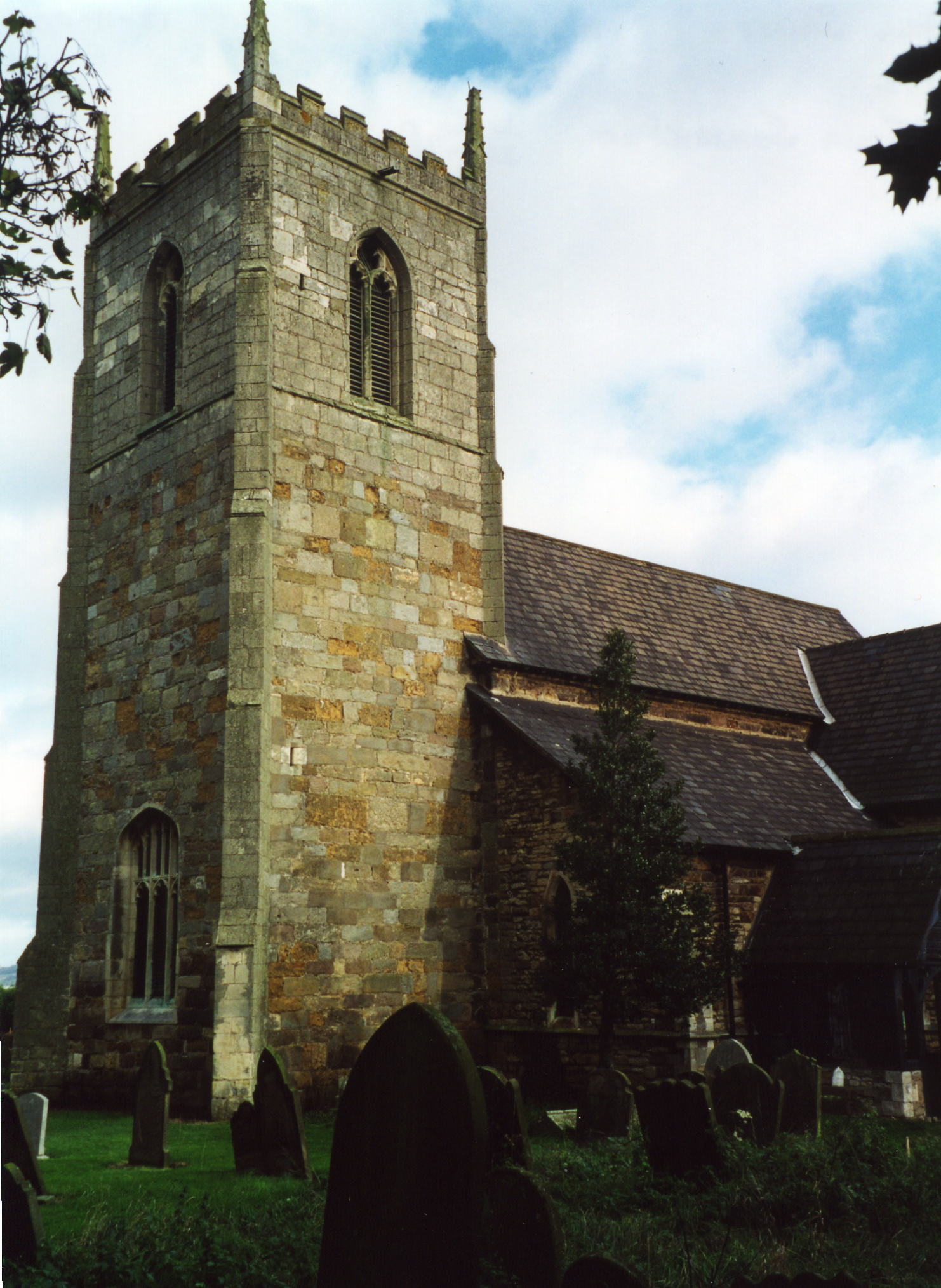
- The Anglican parish church is dedicated to All Saints.
- The church seats 350.
- There is a photograph of All Saints Church on the Wendy PARKINSON Church Photos web site, taken by Paul FENWICK.
- Here is a photo of All Saints Church, taken by Ron COLE (who retains the copyright):
- Parish registers exist from 1627, although entries back to 1562 appear in the Bishop's transcripts.
- Syd Beacroft has offered to do lookups in the parish register for researchers. Contact him at: Syd Beacroft.
- Check the Manlake Deanery to see existing Marriage Indexes.
- A Wesleyan Methodist chapel was built in 1891 and a Primitive Methodist chapel was built in 1837. For information and assistance in researching these chapels, see our non-conformist religions page.
- Check our Church Records page for county-wide resources.
- The parish was in the Winterton sub-district of the Glanford Brigg Registration District.
- Check our Civil Registration page for sources and background on Civil Registration which began in July, 1837.
This village and parish is in the far north of Lincolnshire, bordered on the north by the River Humber and in the south by Winterton parish. The parish covers about 3,970 acres of land.
The village is easy to reach. If you are planning a visit:
- From the A15 trunk road, where it crosses Barton-upon-Humber, take the A1077 west about seven miles to Winteringham.
- Alternately, one could just drive north on Ermine Street to Winteringham.
- Check out our touring page.
- The village has its own website. The site has some Genealogical data, as well.
The National Gazetteer of Great Britain and Ireland - 1868
- Ask for a calculation of the distance from Winteringham to another place.
- Queen Etheldreda landed here after crossing the Humber when she fled her second husband, King Egfrid.
- A half mile east of the village of Winteringham is the site of the Roman town of Ad Abum.
- Ermine Street, the great Roman Road, ended here at a ferry across the Humber.
- In older times, a pleasure faire was held each July 14th.
- The parish had a Temperance Hall built in 1882.
- See our Maps page for additional resources.
You can see maps centred on OS grid reference SE930223 (Lat/Lon: 53.68888, -0.592747), Winteringham which are provided by:
- OpenStreetMap
- Google Maps
- StreetMap (Current Ordnance Survey maps)
- Bing (was Multimap)
- Old Maps Online
- National Library of Scotland (Old Ordnance Survey maps)
- Vision of Britain (Click "Historical units & statistics" for administrative areas.)
- English Jurisdictions in 1851 (Unfortunately the LDS have removed the facility to enable us to specify a starting location, you will need to search yourself on their map.)
- Magic (Geographic information) (Click + on map if it doesn't show)
- GeoHack (Links to on-line maps and location specific services.)
- All places within the same township/parish shown on an Openstreetmap map.
- Nearby townships/parishes shown on an Openstreetmap map.
- Nearby places shown on an Openstreetmap map.
- There is a War Memorial standing in Winteringham, dedicated in 1920.
- David WRIGHT has a photograph of the War Memorial on Geo-graph, taken in 2006.
- The War Memorial is a grade II listed structure with British Heritage.
- During World War II the people of Winteringham "adopted" the destroyer "HMS Vanity."
For a photograph of the Winteringham War Memorial and the names on it, see the Roll of Honour site.
The Imperial War Museum tells us that these are the names from both World Wars on the Memorial:
- Brown, Frank
- Burkill, George
- Burkill, William
- Cox, Frederick J.
- Dodds, Reginald John
- Earl, William
- Field, Elias William
- Green, Albert
- Green, Joseph Herbert
- Hall, Reginald
- Howden, Charles
- Hunsley, Bernard
- Kirkby, Frederick
- Ogg, Charles Albert
- Robinson, John
- The name Winteringham is from the Old English Wintra+inga+ham, or "Homestead of the followers of Wintra". In the 1086 Domesday Book, the village name is little-changed, given as Wintringeham.
[A. D. MILLS, "A Dictionary of English Place-Names," Oxford University Press, 1991]
- This place was an ancient parish in Lincoln county and became a modern Civil Parish when those were established.
- The parish was in the ancient Manley Wapentake in the Glanford division in the parts of Lindsey.
- District governance is currently provided by the North Lincolnshire Council.
- Bastardy cases would be heard at the Winterton petty session hearings.
- After the Poor Law Act reforms of 1834, the parish became part of the Glanford Brigg Poor Law Union.
- A National School was built here in 1845 to hold 143 children. In 1900, the attendance was 79. The school has since closed.
- David WRIGHT has a photograph of the old school on Geo-graph, taken in 2007.
- For more on researching school records, see our Schools Research page.