
Hide
--- TEST SYSTEM --- TEST SYSTEM --- TEST SYSTEM ---
Hide
Tetney
hide
Hide
hide
Hide
hide


Hide
Hide
“TETNEY, a parish in the wapentake of Bradley Haverstoe, parts of Lindsey, county Lincoln, 7 miles S.E. of Great Grimsby, its post town, and 3 N.E. of North Thoresby railway station. The village, which is extensive, is situated on the Louth navigation, near Tetney Haven. It is a coastguard station. The weaving of cloth was formerly carried on. There are several wells of clear water, called ""blow-wells,"" which contain pike and eels. The living is a vicarage* in the diocese of Lincoln, value £250, in the patronage of the bishop. The church, dedicated to SS. Peter and Paul, is an ancient structure with a tower and four bells. The register dates from 1600. The parochial charities produce about £3 per annum. There are Sunday-schools in connection with the church and chapels. The Wesleyans and Primitive Methodists have chapels. The children of this parish have the privilege of being educated in the Humberstone free school. A reading-room was established in 1854, and in the same year the Tetney Agricultural Society was formed. There is a fair on the first Monday following the 12th July."
”
from The National Gazetteer of Great Britain and Ireland - 1868
Hide
The Library at Louth will prove useful in your research.
| Humberston Road, Tetney, Cemetery |
- The parish was in the Tetney sub-district of the Louth Registration District.
- Check our Census Resource page for county-wide resources.
- The table below gives census piece numbers, where known:
| Census Year | Inhabitants |
|---|---|
| 1851 | H.O. 107 / 2112 |
| 1861 | R.G. 9 / 2387 |
| 1871 | R.G. 10 / 3409 & 3410 |
| 1891 | R.G. 12 / 2611 |
- There is evidence of a Saxon church here before the Danes came in 870 and burned it down.
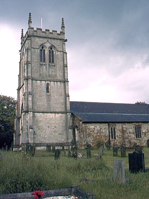
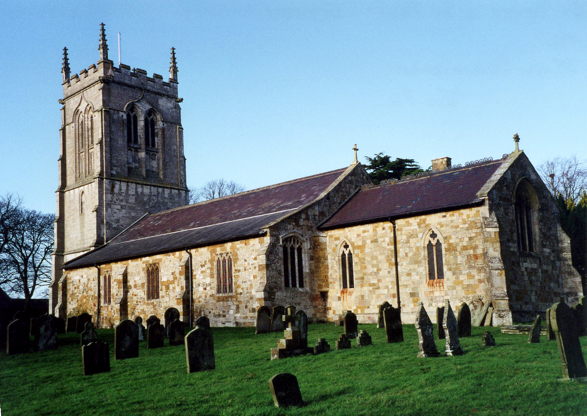
- The church stands at the southern edge of the village.
- The Anglican parish church is dedicated to Saints Peter and Paul. It apparently dates back to before 1363.
- The church nave was apparently reconstructed in 1363.
- The church was restored in 1861-2.
- Electric lighting came to the church in 1929.
- The church seats 400 people.
- Here is a photo of the Anglican church, taken by (and copyright of) Wendy PARKINSON.
Here is a photo of St. Peter and St. Paul Church, taken by Ron COLE (who retains the copyright):
- The Anglican parish register dates from 1720.
- We have a partial Parish Register Extract in a web page. Your additions and corrections are welcome.
- The Lincolnshire FHS has published several marriage indexes and a 1641/2 Protestation Return for the Haverstoe Deanery to make your search easier.
- The Wesleyan Methodists had a small chapel here, built in 1877 in the centre of the village.
- Richard CROFT has a photograph of the Methodist chapel on Geo-graph, taken in September, 2006.
- The Primitive Methodists also had a chapel built in Tetney Lock in 1864. It could seat 140.
- For information and assistance in researching these chapels, see our non-conformist religions page.
- Check our Church Records page for county-wide resources.
- The parish was in the Tetney sub-district of the Louth Registration District.
- Check our Civil Registration page for sources and background on Civil Registration which began in July, 1837.
This parish and village are 6 miles due south of Cleethorpes, and about 3 miles from the North Sea. Humberstone parish is to the north and North Coates parish to the southeast. Tetney Lock is a hamlet in the parish, about 2 miles east from Tetney village, on the Louth Navigation Canal. The parish covers about 6,000 acres.
If you are planning a visit:
- By automobile, take the A1031 trunk road south out of Cleethorpes. The road bisects the village.
- The Village is proud to have wom a "Best Kept Village" award. Ian S. has a photograph of the BKV Award on Geo-graph, taken in November, 2013.
- See our touring page for visitor services.
The National Gazetteer of Great Britain and Ireland - 1868
- Ask for a calculation of the distance from Tetney to another place.
- The village long held a pleasure fair each year around mid-July.
- The Plough Inn serves as the hub of local news and information on the Market square.
- We have a view of he Plough Inn, the bus stop and the market place on Geo-graph, taken by Chris ? in October, 2012.
- Ian S. has a phtograph of the Plough Inn on Geo-graph, taken in December, 2017.
- These are the names associated with the Plough Inn in various directories:
| Year | Person |
|---|---|
| 1842 | -- not listed -- |
| 1868 | -- not listed -- |
| 1872 | George LOCKING, victualler |
| 1882 | Mack ROBINSON |
| 1896 | Mark ROBINSON |
| 1900 | James SPENCER |
| 1913 | James Mayes SPENCE |
| 1930 | Edwd. PHILLIPSON junior |
- See our Maps page for additional resources.
You can see maps centred on OS grid reference TA312015 (Lat/Lon: 53.493458, -0.023432), Tetney which are provided by:
- OpenStreetMap
- Google Maps
- StreetMap (Current Ordnance Survey maps)
- Bing (was Multimap)
- Old Maps Online
- National Library of Scotland (Old Ordnance Survey maps)
- Vision of Britain (Click "Historical units & statistics" for administrative areas.)
- English Jurisdictions in 1851 (Unfortunately the LDS have removed the facility to enable us to specify a starting location, you will need to search yourself on their map.)
- Magic (Geographic information) (Click + on map if it doesn't show)
- GeoHack (Links to on-line maps and location specific services.)
- All places within the same township/parish shown on an Openstreetmap map.
- Nearby townships/parishes shown on an Openstreetmap map.
- Nearby places shown on an Openstreetmap map.
- In 1919 a framed oak tablet was mounted in the church in memory of the men of the parish who died in World War I.
- Ian S. has a photograph of the War Memorial on Geo-graph, taken in November, 2013.
- Steve FAREHAM has a photograph of a Three-bay Pillbox at Tetney Lock on the Traces of War website.
John Readman provides the following, taken from the Roll of Honour at Saints Peter and Paul church (all World War One):
|
|
|
- This place was an ancient parish in Lincolnshire and became a modern Civil Parish when those were established.
- The parish was in the ancient Bradley Haverstoe Wapentake in the East Lindsey district in the parts of Lindsey.
- For today's district governance, see the East Lindsey District Council.
- Bastardy cases would be heard in the Bradley Haverstoe petty session hearings.
- The Common Lands were enclosed here in 1777.
- After the Poor Law Amendment Act of 1834, the parish became part of the Louth Poorlaw Union.
Year Inhabitants 1801 440 1811 489 1831 647 1841 819 1861 917 1871 923 1881 807 1891 775 1901 636 1911 717 1921 790 1931 882 1951 865
- A school board was formed in February, 1873.
- A Council School was built in 1856 to hold up to 152 children. (It was a Wesleyan School at first).
- For more on researching school records, see our Schools Research page.