
Hide
--- TEST SYSTEM --- TEST SYSTEM --- TEST SYSTEM ---
Hide
Swayfield
hide
Hide
hide
Hide
hide
Hide
Hide
hide
- Maps
- Migration, Internal◬
- Military History◬
- Military Records◬
- Monumental Inscriptions
- Names, Geographical
- Names, Personal◬
- Naturalisation & Citizenship◬
- Newspapers◬
- Occupations◬
- Politics & Government
- Poor Houses, Poor Law
- Population
- Postal & Shipping Guides◬
- Probate Records◬
- Public Records◬
- Schools
- Societies◬
- Voting Registers◬
Hide
“SWAYFIELD, a parish in the wapentake of Bettisloe, parts of Kesteven, county Lincoln, 4½ miles S.E. of Colsterworth, its post town, and 1½ mile S.W. of Corby railway station. The village is situated on the Great Northern railway, and on the river Glen. The houses are much scattered. The living is a rectory* in the diocese of Lincoln, value £293, in the patronage of the lord chancellor. The church, dedicated to St. Nicholas, was rebuilt, with the exception of the chancel, in 1824. The parochial charities produce about £2 per annum. The manor is the property of Brown's Hospital, to which the larger portion of the land belongs."
”
from The National Gazetteer of Great Britain and Ireland - 1868
Hide
The Library at Bourne has documents for your research.
Robert HARVEY has a photograph of St. Nicholas' churchyard on Geo-graph, taken in July, 2020.
- The parish was in the Corby sub-district of the Bourne Registration District.
- Check our Census Resource page for county-wide resources.
- The table below gives census piece numbers, where known:
| Census Year | Piece No. |
|---|---|
| 1851 | H.O. 107 / 2095 |
| 1861 | R.G. 9 / 2315 |
| 1871 | R.G. 10 / 3311 |
| 1881 | R.G. 11 / 3195 |
| 1891 | R.G. 12 / 2555 |
| Swayfield, Methodist (Primitive) |
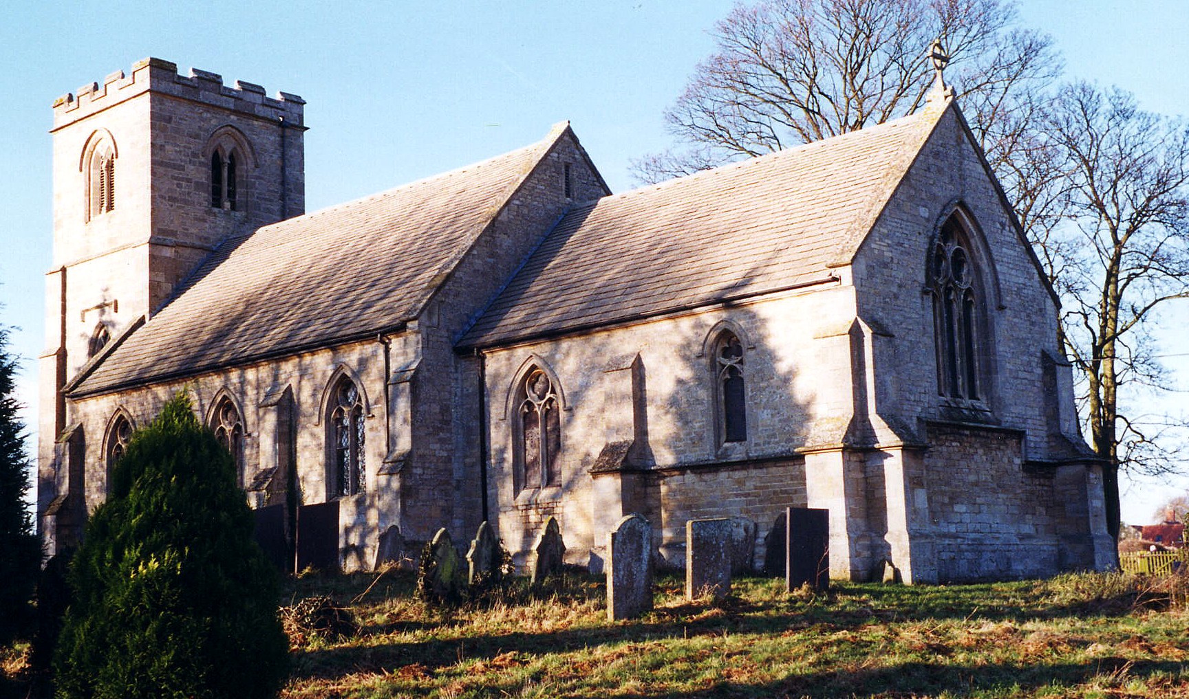
- The Anglican parish church is dedicated to Saint Nicholas.
- The church was originally built in the 12th century.
- The church was rebuilt in 1824 except for the chancel.
- The church nave was rebuilt and enlarged in 1876.
- The church seats 160.
- Here is a photo of St. Nicholas Church, taken by Ron COLE (who retains the copyright):
- Anglican parish registers exist from 1561, although are only deposited in the county archives for the period 1724 - 1912.
- The Bishop's Transcripts are available via the Family History Library for 1561 - 1840.
- The LFHS has published several indexes (marriage and burial) for the Beltisloe Deanery to make your search easier.
- The Primitive Methodists built a small chapel here.
- For information and assistance in researching these chapels, see our non-conformist religions page.
- Check our Church Records page for county-wide resources.
- The parish was in the Corby sub-district of the Bourne Registration District.
- Check our Civil Registration page for sources and background on Civil Registration which began in July 1837.
Swayfield is both a village and parish which lies just north of Castle Bytham parish, 96 miles north of London, 16 miles north of Stamford and 13 miles south-east of Grantham. Swinstead parish lies to the east across the West Glen River. The West Glen River runs along the east boundary of the parish. The parish covers just over 1,530 acres.
If you are planning a visit:
- By automobile, the village lies just east of the A1 trunk road and south of the A151 arterial road.
- J. THOMAS has a photograph of the Village Sign on Geo-graph, taken in October, 2012. The sign was erected in 2002, in celebration of the Queen's Golden Jubilee.
- Andrew TATLOW has a photograph of Entering Swayfield from the west on Geo-graph, taken in August, 2008.
- See our touring page for more sources.
The National Gazetteer of Great Britain and Ireland - 1868
- Ask for a calculation of the distance from Swayfield to another place.
- See our Maps page for additional resources.
You can see maps centred on OS grid reference SK991229 (Lat/Lon: 52.794303, -0.531721), Swayfield which are provided by:
- OpenStreetMap
- Google Maps
- StreetMap (Current Ordnance Survey maps)
- Bing (was Multimap)
- Old Maps Online
- National Library of Scotland (Old Ordnance Survey maps)
- Vision of Britain (Click "Historical units & statistics" for administrative areas.)
- English Jurisdictions in 1851 (Unfortunately the LDS have removed the facility to enable us to specify a starting location, you will need to search yourself on their map.)
- Magic (Geographic information) (Click + on map if it doesn't show)
- GeoHack (Links to on-line maps and location specific services.)
- All places within the same township/parish shown on an Openstreetmap map.
- Nearby townships/parishes shown on an Openstreetmap map.
- Nearby places shown on an Openstreetmap map.
Robert HARVEY has recorded this monument inscription by photograph on Geo-graph, taken in July, 2020. It is the life of two people: Harold Ernest SHARPE of Little Bytham and his bride Barbara Eleanor BACON of Swayfield.
- The name derives from the Old English Swaethfeld or "open land with swathes (tracks)," and is listed in the 1086 Domesday Book as Suafeld, and in 1206 as Swathefeld.
[A. D. MILLS, "A Dictionary of English Place-Names," Oxford University Press, 1991]
- The name is also found in many old records without the "Y", as in Swafield.
- The parish was in the North Division of the ancient Beltisloe Wapentake in the South Kesteven district in the parts of Kesteven.
- Rex NEEDLE provides a photograph of a sunlit Village Hall on Geo-graph, taken in September, 1999. It replaces a corrugated iron hut left over from World War II.
- Robert HARVEY has a photograph of the Village Map on Geo-graph, taken in July, 2019.
- You may contact the Swayfield Parish Council regarding civic or political metters, but they will NOT do family history searches for you.
- For today's district governance, contact the South Kesteven District Council.
- Bastardy cases would be heard in the Bourne petty session hearings on Mondays.
- The Common Lands were enclosed here around 1799.
- Edward MOULTON left land at Donington to generate £2 per year which went to the poor.
- As a result of the Poor Law Amendment Act reforms of 1834, the parish became part of the Bourne Poor Law Union.
- A Parochial School was built in 1867 and enlarged in 1885 to hold 90 children.
- For more on researching school records, see our Schools Research page.